Fitxer:Backenswarft, Hallig Hooge, Germany.jpg
Mida d'aquesta previsualització: 800 × 425 píxels. Altres resolucions: 320 × 170 píxels | 640 × 340 píxels | 1.024 × 544 píxels | 1.280 × 680 píxels | 2.738 × 1.455 píxels.
Fitxer original (2.738 × 1.455 píxels, mida del fitxer: 3,22 Mo, tipus MIME: image/jpeg)
| Aquest fitxer i la informació mostrada a continuació provenen del dipòsit multimèdia lliure Wikimedia Commons. |
Resum
| Descripció |
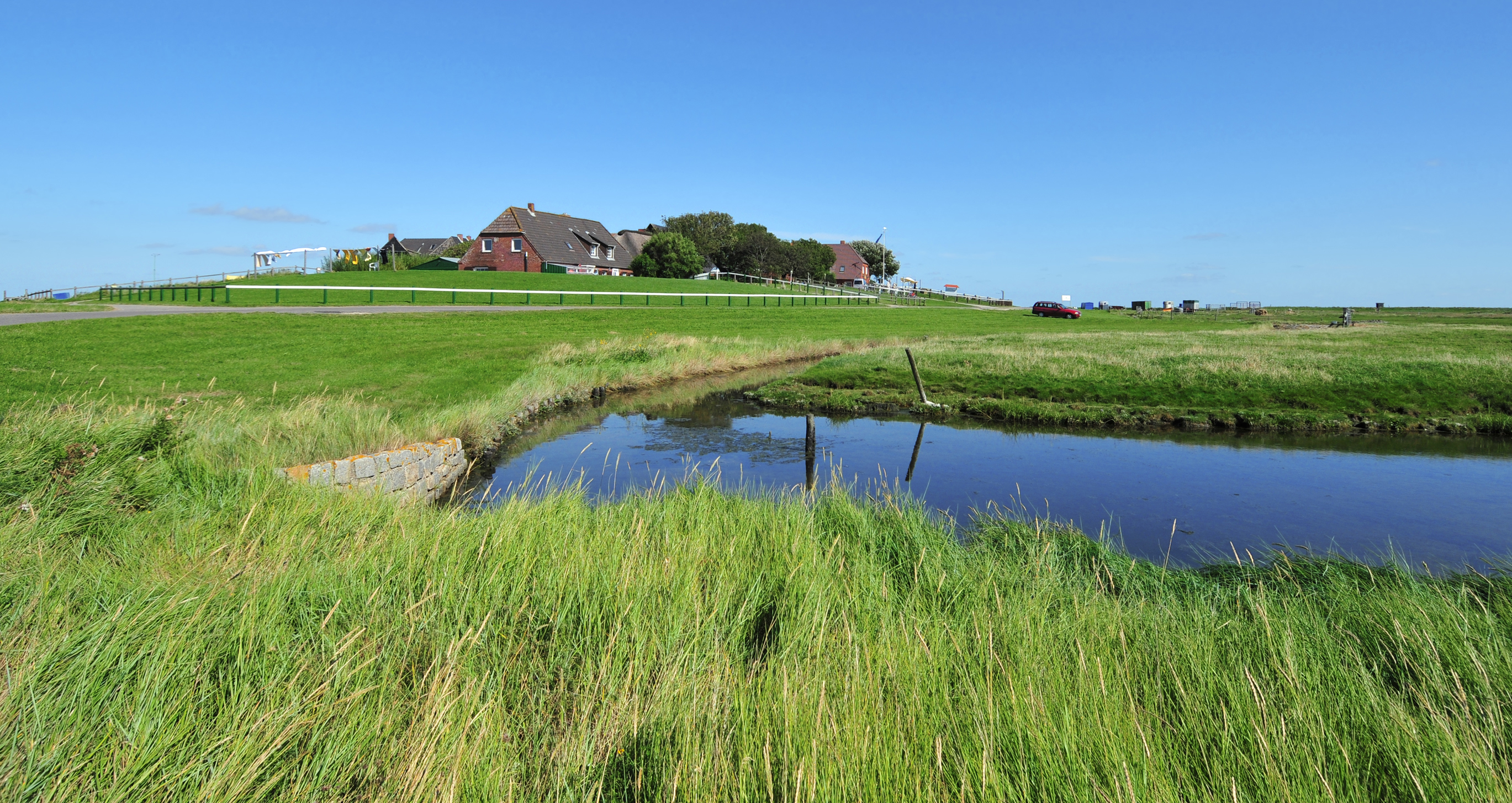
Deutsch: Blick auf die Backenswarft. Sie steht auf der Hallig Hooge. Die Hallig Hooge ist die zweitgrößte der zehn Halligen im Schleswig-Holsteinischen Wattenmeer. Hallig Hooge ist von einem rund 1,20 Meter hohen Steindeich umgeben und ist dadurch bei leichten Sturmfluten vor Landunter geschützt. Dennoch wird die Hallig Hooge zwei bis fünf Mal im Jahr vollständig überflutet. Die Wohnhäuser stehen auf hohen Warften, damit sie den Sturmfluten widerstehen können. Die Hallig Hooge besitzt zwölf Warften. Die Backenswarft ist die zweitgrößte Warft mit einem Dutzend Gebäuden, die ringförmig den Fething mit Regenwasser umschließen und vor Salzwasser schützen.
English: View to the Backenswarft on Hallig Hooge. The Hallig Hooge is the second largest of the ten islets in the Schleswig-Holstein Wadden Sea. Hallig Hooge is surrounded by an approximately 1.20 meters high stone dyke and is thus protected from light storm surges. Nevertheless Hallig Hooge is flooded completely two to five times a year. The Houses are built on high mounds. Therefore they can withstand the storm surges. The Hallig Hooge has twelve mounds. The Backenswarft is the second largest mound with a dozen buildings. The buildings surround the pond with rainwater. |
| Data | Taken on 27 d'agost de 2012 |
| Font | Treball propi |
| Autor | Michael Gäbler |
| Posició de la càmera | | Aquesta i altres imatges properes a: OpenStreetMap |
|---|
Llicència
Michael Gäbler, el titular dels drets d'autor d'aquest treball, el public sota la següent llicència:
Aquest fitxer està subjecte a la llicència de Creative Commons Reconeixement 3.0 No adaptada.
Reconeixement: Michael Gäbler
- Sou lliure de:
- compartir – copiar, distribuir i comunicar públicament l'obra
- adaptar – fer-ne obres derivades
- Amb les condicions següents:
- reconeixement – Heu de donar la informació adequada sobre l'autor, proporcionar un enllaç a la llicència i indicar si s'han realitzat canvis. Podeu fer-ho amb qualsevol mitjà raonable, però de cap manera no suggereixi que l'autor us dóna suport o aprova l'ús que en feu.
Assessment
|
Historial del fitxer
Cliqueu una data/hora per veure el fitxer tal com era aleshores.
| Data/hora | Miniatura | Dimensions | Usuari/a | Comentari | |
|---|---|---|---|---|---|
| actual | 21:55, 23 set 2012 | | 2.738 × 1.455 (3,22 Mo) | Michael Gäbler | {{Information |Description= {{de|1= Blick auf die Backenswarft. Sie steht auf der Hallig Hooge. Die Hallig Hooge ist die zweitgrößte der zehn Halligen in dem [[:de:Nationalpark Schleswig-Holstei... |
Ús del fitxer
La pàgina següent utilitza aquest fitxer:
Ús global del fitxer
Utilització d'aquest fitxer en altres wikis:
- Utilització a ace.wikipedia.org
- Utilització a da.wikipedia.org
- Utilització a de.wikipedia.org
- Utilització a en.wikipedia.org
- Utilització a eo.wikipedia.org
- Utilització a ka.wikipedia.org
- Utilització a mk.wikipedia.org
- Utilització a nl.wikipedia.org
- Utilització a pt.wikipedia.org
- Utilització a ro.wikipedia.org
- Utilització a ru.wikipedia.org
- Utilització a sv.wikipedia.org
- Utilització a war.wikipedia.org