Fitxer:CarthageMap.png
No hi ha cap versió amb una resolució més gran.
CarthageMap.png (770 × 447 píxels, mida del fitxer: 106 Ko, tipus MIME: image/png)
| Aquest fitxer i la informació mostrada a continuació provenen del dipòsit multimèdia lliure Wikimedia Commons. |
Resum
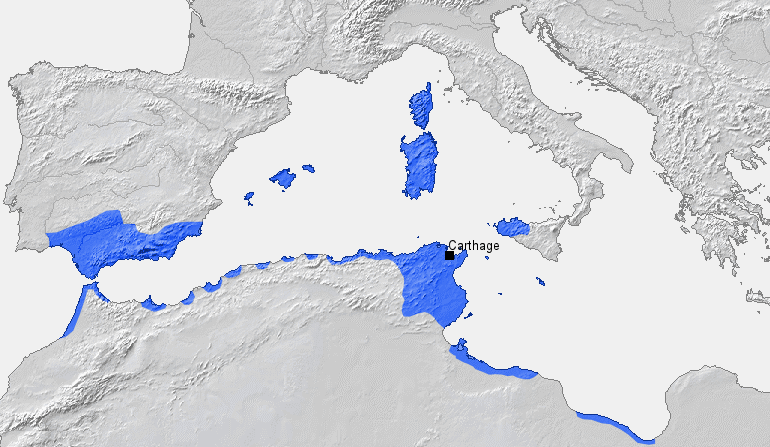
| Descripció |
Location of Carthage and Carthaginian sphere of influence prior to the First Punic War (264 BC) Source: Self-made, based on Putzger Atlas und Chronik zur Weltgeschichte, Berlin, 2002 Template: [1] Author: BishkekRocks |
||
| Data | 18 de març de 2006 (original upload date) | ||
| Font | No machine-readable source provided. Own work assumed (based on copyright claims). | ||
| Autor | No machine-readable author provided. BishkekRocks assumed (based on copyright claims). | ||
| Altres versions |
|

Llicència
| Jo, el titular del copyright d'aquesta obra, l'allibero al domini públic. Això s'aplica a tot el món. En alguns països això pot no ser legalment possible, en tal cas: Jo faig concessió a tothom del dret d'usar aquesta obra per a qualsevol propòsit, sense cap condició llevat d'aquelles requerides per la llei. |
Historial del fitxer
Cliqueu una data/hora per veure el fitxer tal com era aleshores.
| Data/hora | Miniatura | Dimensions | Usuari/a | Comentari | |
|---|---|---|---|---|---|
| actual | 21:50, 6 abr 2023 | | 770 × 447 (106 Ko) | Titanjs | Reverted to version as of 15:31, 18 March 2006 (UTC) |
| 16:16, 23 març 2016 |  | 770 × 447 (288 Ko) | Michczu | drobna poprawka | |
| 18:52, 19 set 2014 |  | 770 × 447 (128 Ko) | Daygum | True areas occupied by chartaginians | |
| 17:31, 18 març 2006 |  | 770 × 447 (106 Ko) | BishkekRocks | Location of Carthage and Carthaginian influence sphere before the First Punic War (264 BC) Source: Self-made, based on Putzger Atlas und Chronik zur Weltgeschichte, Berlin, 2002 Template: [http://www.demis.nl/wms/mapclip.htm] Author: ~~~ [[Category:Ca |
Ús del fitxer
Les 3 pàgines següents utilitzen aquest fitxer:
Ús global del fitxer
Utilització d'aquest fitxer en altres wikis:
- Utilització a ar.wikipedia.org
- Utilització a ast.wikipedia.org
- Utilització a azb.wikipedia.org
- Utilització a az.wikipedia.org
- Utilització a ba.wikipedia.org
- Utilització a be-tarask.wikipedia.org
- Utilització a bg.wikipedia.org
- Utilització a bm.wikipedia.org
- Utilització a br.wikipedia.org
- Utilització a bs.wikipedia.org
- Utilització a cdo.wikipedia.org
- Utilització a cs.wikipedia.org
- Utilització a de.wikipedia.org
- Utilització a el.wikipedia.org
- Utilització a en.wikipedia.org
- Utilització a eo.wikipedia.org
- Utilització a es.wikipedia.org
- Utilització a et.wikipedia.org
Vegeu més usos globals d'aquest fitxer.