Fitxer:Cerro del Plomo route.jpeg

Fitxer original (4.224 × 2.376 píxels, mida del fitxer: 2,43 Mo, tipus MIME: image/jpeg)
| Aquest fitxer i la informació mostrada a continuació provenen del dipòsit multimèdia lliure Wikimedia Commons. |
Resum
| Descripció |
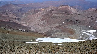
English: Looking south on most of the Cerro del Plomo route.
Somewhat to the left, near the greenish spots deep down in the Estero Cepo valley, is the Piedra Numerada base camp (approx. 3,400m). The route then follows this valley to La Hoya (or La Olla; approx. 4,200m), which is hidden by the moraine at the far right of the picture. From this moraine, the track is clearly visible on the picture, going first to the newly rebuilt Refugio Agostini (the red dot near the center of the picture; 4,620m), and then in steep hairpins (mostly hidden) to the easy traverse at the far left. From here it is less than two hours to the summit, with, immediately beyond the Pirca del Inca burial site, a short glacier crossing. El Pintor (approx. 4,200m) can be seen in the background. The Cerro del Plomo (5,424m) is not to be confused with the Nevado El Plomo (6,070m), which lies on the border about 20km to the north-east. (Cf. John Biggar, The Andes — A Guide for Climbers, ISBN 0-9536087-2-7, p. 217; Hermann Kiendler, Die Anden — Vom Chimborazo zum Marmolejo — Alle 6000er auf einen Blick, ISBN 978-3-936740-36-3, pp. 349–352.) |
| Data | |
| Font | Treball propi |
| Autor | Tijs Michels |
| Permís (Com reutilitzar aquest fitxer) |
cc-by-sa-3.0 (attribution required - see below) |
Llicència
- Sou lliure de:
- compartir – copiar, distribuir i comunicar públicament l'obra
- adaptar – fer-ne obres derivades
- Amb les condicions següents:
- reconeixement – Heu de donar la informació adequada sobre l'autor, proporcionar un enllaç a la llicència i indicar si s'han realitzat canvis. Podeu fer-ho amb qualsevol mitjà raonable, però de cap manera no suggereixi que l'autor us dóna suport o aprova l'ús que en feu.
- compartir igual – Si modifiqueu, transformeu, o generareu amb el material, haureu de distribuir les vostres contribucions sota una llicència similar o una de compatible com l'original
Historial del fitxer
Cliqueu una data/hora per veure el fitxer tal com era aleshores.
| Data/hora | Miniatura | Dimensions | Usuari/a | Comentari | |
|---|---|---|---|---|---|
| actual | 22:20, 21 març 2010 | | 4.224 × 2.376 (2,43 Mo) | Tmichels | {{Information |Description={{en|1=Looking south on most of the Cerro del Plomo route. Somewhat to the left, near the greenish spots deep down in the Estero Cepo valley, is the Piedra Numerada base camp (approx. 3,400m). The route t |
Ús del fitxer
La pàgina següent utilitza aquest fitxer:
Ús global del fitxer
Utilització d'aquest fitxer en altres wikis:
- Utilització a en.wikipedia.org
- Utilització a eo.wikipedia.org
- Utilització a es.wikipedia.org
- Utilització a ru.wikipedia.org
- Utilització a uk.wikipedia.org