Fitxer:Czechoslovakia IV.png
Mida d'aquesta previsualització: 800 × 364 píxels. Altres resolucions: 320 × 146 píxels | 640 × 291 píxels | 1.128 × 513 píxels.
Fitxer original (1.128 × 513 píxels, mida del fitxer: 130 Ko, tipus MIME: image/png)
| Aquest fitxer i la informació mostrada a continuació provenen del dipòsit multimèdia lliure Wikimedia Commons. |
| Descripció |
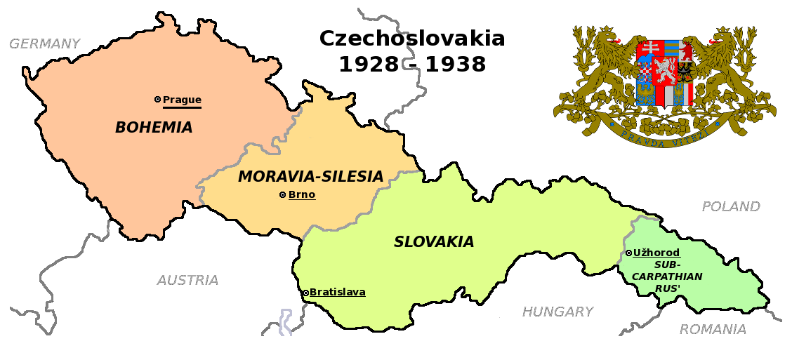
Čeština: Zemská mapa Československa v letech 1928 až 1938 s vyznačenými zemskými hlavními městy English: Maps of Czechoslovakia in 1928-1938 with marked borders of all four Czechoslovak lands and their regional capital cities |
| Data | (UTC) |
| Font | |
| Autor |
|
| Altres versions |
Derivative works of this file: |
| Això és una imatge retocada, cosa que vol dir que ha estat alterada digitalment de la seva versió original. Modificacions: Simplified map. L'original es pot veure a: Czechoslovakia COA large.svg:
|
Aquest fitxer està subjecte a la llicència de Creative Commons Reconeixement i Compartir Igual 3.0 No adaptada.
- Sou lliure de:
- compartir – copiar, distribuir i comunicar públicament l'obra
- adaptar – fer-ne obres derivades
- Amb les condicions següents:
- reconeixement – Heu de donar la informació adequada sobre l'autor, proporcionar un enllaç a la llicència i indicar si s'han realitzat canvis. Podeu fer-ho amb qualsevol mitjà raonable, però de cap manera no suggereixi que l'autor us dóna suport o aprova l'ús que en feu.
- compartir igual – Si modifiqueu, transformeu, o generareu amb el material, haureu de distribuir les vostres contribucions sota una llicència similar o una de compatible com l'original
Registre original de càrregues
This image is a derivative work of the following images:
- File:Czechoslovakia01.png licensed with PD-self
- 2011-05-19T10:54:48Z PANONIAN 1128x513 (64020 Bytes) minor change, marked provincial capitals
- 2011-05-17T09:53:27Z PANONIAN 1128x513 (63994 Bytes) Reverted to version as of 10:38, 24 April 2011 - because this is map of Czechoslovakia and it was capital of Czechoslovakia
- 2011-05-17T05:07:38Z Millenium187 1128x513 (56086 Bytes) Why was Prague underlined and Vienna, Brno, Bratislava and other capital cities were not? -- corrected
- 2011-04-24T10:38:30Z PANONIAN 1128x513 (63994 Bytes) few corrections
- 2011-04-23T11:31:49Z PANONIAN 1128x509 (62348 Bytes) improved version
- 2008-12-20T20:58:14Z Kirk 1100x497 (80038 Bytes) {{Information |Description= |Source= |Date= |Author= |Permission= |other_versions= }}
- 2006-12-28T16:11:35Z Electionworld 1100x497 (92110 Bytes) {{ew|en|PANONIAN}} Map of {{link|Czechoslovakia}} (self made) Note: The provinces shown on the map were introduced by Act No. 125/1927 Zb. and became effective in 1928. {{PD-self}} [[Category:Maps of Czechoslovakia]] [[Cat
- File:Czechoslovakia_COA_large.svg licensed with Cc-by-sa-3.0-migrated, GFDL
- 2010-09-06T23:55:59Z Fry1989 635x350 (1316079 Bytes) Reverted to version as of 23:52, 6 September 2010 this version will have to stay, message me with any corrections you want and I'll see what I can do
- 2010-09-06T23:53:49Z Kwasura 635x350 (1440388 Bytes) correction
- 2010-09-06T23:52:33Z Fry1989 635x350 (1316079 Bytes) lets see if it'll upload for me, checks out fine in inkscape
- 2010-09-06T23:50:19Z Kwasura 635x350 (1440373 Bytes) correction
- 2010-08-12T19:52:16Z Delta 51 635x350 (1440480 Bytes) Reverted to version as of 08:13, 5 November 2006 (the new versions don't work at all)
- 2010-08-09T20:16:25Z Kwasura 635x350 (1026422 Bytes) trying
- 2010-08-09T20:06:57Z Kwasura 635x350 (1976 Bytes) well, I just don't know how to do it...
- 2010-08-09T20:05:24Z Kwasura 635x350 (1976 Bytes) one more try
- 2010-08-09T20:02:09Z Kwasura 635x350 (1976 Bytes) correction 2nd try
- 2010-08-09T19:57:24Z Kwasura 635x350 (1976 Bytes) correction
- 2006-11-05T08:13:30Z Happenstance 635x350 (1440480 Bytes) crowns for the eagles
- 2006-06-17T05:00:05Z Happenstance 635x350 (1439900 Bytes) ==Author:== * commons: [[user:Shazz|Shazz]] * pl.wiki: [[w:pl:user:Shazz|Shazz]] ==Description== * '''cs:''' Znak Československa - velký * '''pl:''' Godło Czechosłowacji - duże * '''en:''' Coat of Arms of Czechoslovakia
Uploaded with derivativeFX
Historial del fitxer
Cliqueu una data/hora per veure el fitxer tal com era aleshores.
| Data/hora | Miniatura | Dimensions | Usuari/a | Comentari | |
|---|---|---|---|---|---|
| actual | 20:36, 12 ago 2011 | | 1.128 × 513 (130 Ko) | Millenium187 | {{Information |Description={{cs|Zemská mapa Československa v letech 1928 až 1938}} {{en|Maps of Czechoslovakia in 1928-1938 with marked borders of all four Czechoslovak countries}} |Source=*File:Czechoslovakia01.png *[[:File:Czechoslovakia_COA_l |
Ús del fitxer
La pàgina següent utilitza aquest fitxer:
Ús global del fitxer
Utilització d'aquest fitxer en altres wikis:
- Utilització a en.wikipedia.org
- Utilització a fa.wikipedia.org
- Utilització a fr.wikipedia.org
- Utilització a ps.wikipedia.org