Fitxer:Dalsfjorden Rivedal.jpg

Fitxer original (2.394 × 1.107 píxels, mida del fitxer: 1,47 Mo, tipus MIME: image/jpeg)
| Aquest fitxer i la informació mostrada a continuació provenen del dipòsit multimèdia lliure Wikimedia Commons. |
Resum
| Descripció |
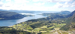
Norsk nynorsk: The image is cropped by me, User:Jorunn Neset ca. midt i biletet, på andre sida av fjorden, er Straumsnes. Innom Straumsnes heiter fjorden Dalsfjorden, utom heiter han Vilnesfjorden. Landet på andre sidan av fjorden er i Fjaler kommune, medan det på den sida der fotografen er er Askvoll. Gardane nedom fjellet/åsen fotografen er på er i Rivedal. Vegen ein ser gå ned mot fjorden til venstre i biletet er Riksveg 609. Vegen ein kan sjå konturane av på andre sida av fjorden er Fylkesveg 394 i Sogn og Fjordane. Vatnet til høgre i biletet er Bakkevatnet. In English (Translation by MyLegAlta) : The point near the centre of the picture, on the other side of the fjord, is Straumsnes. Beyond Straumsnes, the fjord is called Vilnesfjorden, and inland from that point, it is named Dalsfjord. The municipality of Fjaler is on the other side of the fjord, while the photo was taken from the municipality of Askvoll.The farms seen blow the mountain form the which the photo was taken are located in Rivedal. The road on the left side of the picture going down towards the fjord is Riksveg 609. The contour of Fylkesveg 394 can be seen on the other side of the fjord. The body of water on the right of the picture is called Bakkevatnet. |
| Data | |
| Font | Flickr.com |
| Autor | Jarkko Laine |
Llicència
- Sou lliure de:
- compartir – copiar, distribuir i comunicar públicament l'obra
- adaptar – fer-ne obres derivades
- Amb les condicions següents:
- reconeixement – Heu de donar la informació adequada sobre l'autor, proporcionar un enllaç a la llicència i indicar si s'han realitzat canvis. Podeu fer-ho amb qualsevol mitjà raonable, però de cap manera no suggereixi que l'autor us dóna suport o aprova l'ús que en feu.
| Aquesta imatge, originalment publicada a Flickr, ha estat verificada l'1r de desembre de 2008 per l'administrador o usuari acreditat Mitchazenia, i ha confirmat que en aquella data estava disponible a Flickr sota la llicència indicada. |
Historial del fitxer
Cliqueu una data/hora per veure el fitxer tal com era aleshores.
| Data/hora | Miniatura | Dimensions | Usuari/a | Comentari | |
|---|---|---|---|---|---|
| actual | 22:33, 1 des 2008 | | 2.394 × 1.107 (1,47 Mo) | Jorunn | {{Information |Description={{nn|1=The image is cropped by me, User:Jorunn Neset ca. midt i biletet, på andre sida av fjorden, er Straumsnes. Innom Straumsnes heiter fjorden Dalsfjorden, utom heiter han Vilnesfjorden. Landet på andre sidan av fjorde |
Ús del fitxer
La pàgina següent utilitza aquest fitxer:
Ús global del fitxer
Utilització d'aquest fitxer en altres wikis:
- Utilització a ceb.wikipedia.org
- Utilització a da.wikipedia.org
- Utilització a en.wikipedia.org
- Utilització a eo.wikipedia.org
- Utilització a es.wikipedia.org
- Utilització a eu.wikipedia.org
- Utilització a fi.wikipedia.org
- Utilització a fr.wikipedia.org
- Utilització a it.wikipedia.org
- Utilització a nn.wikipedia.org
- Utilització a no.wikipedia.org
- Utilització a pl.wikipedia.org
- Utilització a ro.wikipedia.org
- Utilització a ru.wikipedia.org
- Utilització a sl.wikipedia.org
- Utilització a sv.wikipedia.org
- Utilització a www.wikidata.org
- Utilització a zh.wikipedia.org