Fitxer:Dersim districts.png
Mida d'aquesta previsualització: 776 × 600 píxels. Altres resolucions: 311 × 240 píxels | 621 × 480 píxels | 994 × 768 píxels | 1.056 × 816 píxels.
Fitxer original (1.056 × 816 píxels, mida del fitxer: 30 Ko, tipus MIME: image/png)
| Aquest fitxer i la informació mostrada a continuació provenen del dipòsit multimèdia lliure Wikimedia Commons. |
Resum
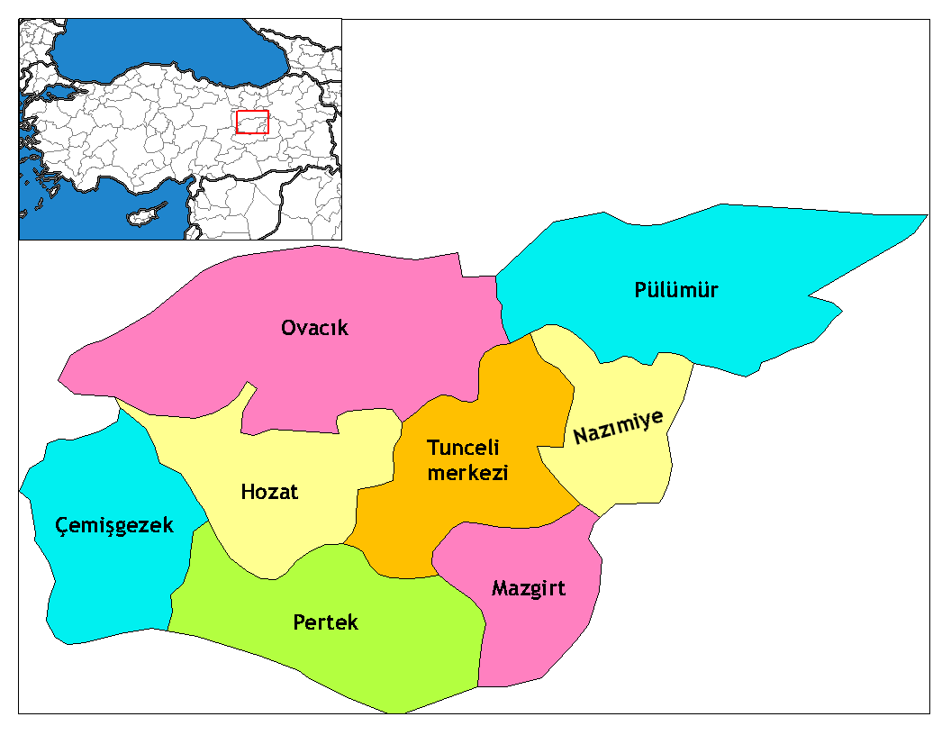
| Descripció | Map of the districts of Tunceli province in Turkey. Created by Rarelibra 17:52, 4 December 2006 (UTC) for public domain use, using MapInfo Professional v8.5 and various mapping resources. Edited by One Homo Sapiens Corrected text where İ,Ş,ı,ğ,or ş occurs in name. Source: [statoids-com]. Increased font size and enhanced color differences among adjacent districts. |
| Data | 4 de desembre de 2006 (original upload date) |
| Font | No machine-readable source provided. Own work assumed (based on copyright claims). |
| Autor | No machine-readable author provided. Rarelibra assumed (based on copyright claims). |
Llicència
| Jo, el titular del copyright d'aquesta obra, l'allibero al domini públic. Això s'aplica a tot el món. En alguns països això pot no ser legalment possible, en tal cas: Jo faig concessió a tothom del dret d'usar aquesta obra per a qualsevol propòsit, sense cap condició llevat d'aquelles requerides per la llei. |
Historial del fitxer
Cliqueu una data/hora per veure el fitxer tal com era aleshores.
| Data/hora | Miniatura | Dimensions | Usuari/a | Comentari | |
|---|---|---|---|---|---|
| actual | 13:39, 8 juny 2014 | | 1.056 × 816 (30 Ko) | Semsûrî | Changed the name |
| 04:50, 29 des 2008 |  | 1.056 × 816 (30 Ko) | One Homo Sapiens | Corrected text where İ,Ş,ı,ğ,or ş occurs in name. Source: [statoids-com]. Increased font size and enhanced color differences among adjacent districts. | |
| 19:52, 4 des 2006 |  | 1.056 × 816 (30 Ko) | Rarelibra | Map of the districts of Tunceli province in Turkey. Created by ~~~~ for public domain use, using MapInfo Professional v8.5 and various mapping resources. |
Ús del fitxer
Les 2 pàgines següents utilitzen aquest fitxer:
Ús global del fitxer
Utilització d'aquest fitxer en altres wikis:
- Utilització a ar.wikipedia.org
- Utilització a arz.wikipedia.org
- Utilització a ast.wikipedia.org
- Utilització a az.wikipedia.org
- Utilització a be.wikipedia.org
- Utilització a ceb.wikipedia.org
- Utilització a cs.wikipedia.org
- Utilització a de.wikipedia.org
- Tunceli
- Mazgirt
- Nazımiye
- Hozat
- Pertek
- Pülümür
- Ovacık (Tunceli)
- Çemişgezek
- Vorlage:Navigationsleiste Landkreise der Provinz Tunceli
- Akdemir (Pertek)
- Aşağıgülbahçe
- Elmakaşı
- Yenisöğüt
- Yaylagünü
- Yarımkaya
- Yakatarla
- Tatuşağı
- Paşadüzü
- Öveçler
- Mollaaliler
- Kozluca
- Koyungölü
- Konaklar (Ovacık)
- Havuzlu
- Güneykonak
- Gözeler
- Eskigedik
- Çöğürlük
- Çemberlitaş
- Çakmaklı
- Büyükköy (Ovacık)
- Aşağıtorunoba
- Arslandoğmuş
- Akyayık
- Yukarıyakabaşı
- Yeniköy (Pertek)
- Tozkoparan
- Pirinççi
- Pınarlar (Pertek)
- Konurat
- Koçpınar
- Karagüney
Vegeu més usos globals d'aquest fitxer.