Fitxer:Detailed map of Benson, Arizona.png
No hi ha cap versió amb una resolució més gran.
Detailed_map_of_Benson,_Arizona.png (575 × 425 píxels, mida del fitxer: 24 Ko, tipus MIME: image/png)
| Aquest fitxer i la informació mostrada a continuació provenen del dipòsit multimèdia lliure Wikimedia Commons. |

|
Aquesta imatge (de tipus city map) s'hauria de tornar a crear utilitzant gràfics vectorials com ara un fitxer SVG. Això té diversos avantatges; en trobareu més informació a Commons:Media for cleanup. Si ja disposeu d'una versió d'aquesta imatge en format SVG, us preguem que la pengeu; després, reemplaceu aquesta plantilla amb la plantilla {{Vector version available|nom nou de la imatge.svg}} en aquesta imatge.
|
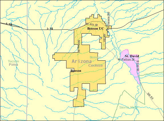
| Descripció | Map of Benson, a city in Cochise County, Arizona, United States, with its boundaries at the time of the 2000 census. | |||
| Data | Data desconeguda; downloaded by me on 13 December 2008 | |||
| Font | http://factfinder.census.gov/leg2/46/120825446.gif, from http://factfinder.census.gov | |||
| Autor | United States Census Bureau | |||
| Permís (Com reutilitzar aquest fitxer) |
|

Historial del fitxer
Cliqueu una data/hora per veure el fitxer tal com era aleshores.
| Data/hora | Miniatura | Dimensions | Usuari/a | Comentari | |
|---|---|---|---|---|---|
| actual | 03:57, 14 des 2008 | | 575 × 425 (24 Ko) | Nyttend | {{Information |Description=Map of {{w|Benson, Arizona|Benson}}, a city in {{w|Cochise County, Arizona|Cochise County}}, {{w|Arizona}}, {{w|United States}}, with its boundaries at the time of the {{w|2000 United States Census|2000 census}}. |Source=http:// |
Ús del fitxer
La pàgina següent utilitza aquest fitxer:
Ús global del fitxer
Utilització d'aquest fitxer en altres wikis:
- Utilització a ar.wikipedia.org
- Utilització a arz.wikipedia.org
- Utilització a azb.wikipedia.org
- Utilització a ceb.wikipedia.org
- Utilització a en.wikipedia.org
- Utilització a eu.wikipedia.org
- Utilització a fa.wikipedia.org
- Utilització a fr.wikipedia.org
- Utilització a sr.wikipedia.org
- Utilització a sv.wikipedia.org
- Utilització a tt.wikipedia.org
- Utilització a ur.wikipedia.org
- Utilització a www.wikidata.org
- Utilització a zh-min-nan.wikipedia.org
- Utilització a zh.wikipedia.org