Fitxer:Ilemi triangle map.PNG

Mida d'aquesta previsualització: 800 × 592 píxels. Altres resolucions: 320 × 237 píxels | 640 × 473 píxels | 990 × 732 píxels.
Fitxer original (990 × 732 píxels, mida del fitxer: 85 Ko, tipus MIME: image/png)
| Aquest fitxer i la informació mostrada a continuació provenen del dipòsit multimèdia lliure Wikimedia Commons. |
Resum
| Descripció |
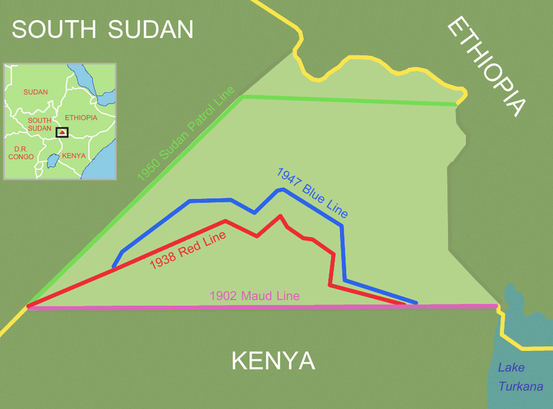
Ilemi triangle (light area), disputed area between Ethiopia, Sudan and Kenya
Reference and further information: DELIMITATION OF THE ELASTIC ILEMI TRIANGLE: PASTORAL CONFLICTS AND OFFICIAL INDIFFERENCE IN THE HORN OF AFRICA See also: satellite image |
| Data | 24 de març de 2006 (original upload date) |
| Font | No machine-readable source provided. Own work assumed (based on copyright claims). |
| Autor | No machine-readable author provided. Roke~commonswiki assumed (based on copyright claims). |
Llicència
Jo, el titular dels drets d'autor d'aquest treball, el public sota la següent llicència:

|
S'autoritza la còpia, la distribució i la modificació d'aquest document sota els termes de la llicència de documentació lliure GNU versió 1.2 o qualsevol altra versió posterior que publiqui la Free Software Foundation; sense seccions invariants, ni textos de portada, ni textos de contraportada. S'inclou una còpia d'aquesta llicència en la secció titulada GNU Free Documentation License. |
| Aquest fitxer està subjecte a la llicència de Creative Commons Reconeixement i Compartir Igual 3.0 No adaptada. | ||
| ||
| Aquest avís de llicència s'ha afegit a aquest fitxer d'acord amb l'actualització de la llicència GFDL. |
Historial del fitxer
Cliqueu una data/hora per veure el fitxer tal com era aleshores.
| Data/hora | Miniatura | Dimensions | Usuari/a | Comentari | |
|---|---|---|---|---|---|
| actual | 16:00, 9 jul 2011 | | 990 × 732 (85 Ko) | Nicolay Sidorov | + South Sudan |
| 14:43, 19 juny 2006 |  | 990 × 732 (118 Ko) | Roke~commonswiki | try again, something wrong with thumbnail on WP | |
| 13:59, 14 juny 2006 |  | 990 × 732 (451 Ko) | Roke~commonswiki | Reverted to earlier revision | |
| 13:58, 14 juny 2006 |  | 990 × 732 (46 Ko) | Roke~commonswiki | version without satellite, less confusing | |
| 04:46, 24 març 2006 |  | 990 × 732 (451 Ko) | Roke~commonswiki | Ilemi triangle, disputed area between Ethiopia, Sudan and Kenya The satellite image was a Public domain image from NASA World Wind, the other information was added with Corel Painter IX Category: Kenya Category: Ethiopia Category: Sudan |
Ús del fitxer
La pàgina següent utilitza aquest fitxer:
Ús global del fitxer
Utilització d'aquest fitxer en altres wikis:
- Utilització a be.wikipedia.org
- Utilització a cs.wikipedia.org
- Utilització a de.wikipedia.org
- Utilització a en.wikipedia.org
- Utilització a es.wikipedia.org
- Utilització a fr.wikipedia.org
- Utilització a hi.wikipedia.org
- Utilització a hr.wikipedia.org
- Utilització a id.wikipedia.org
- Utilització a it.wikipedia.org
- Utilització a ja.wikipedia.org
- Utilització a ka.wikipedia.org
- Utilització a ko.wikipedia.org
- Utilització a lt.wikipedia.org
- Utilització a nl.wikipedia.org
- Utilització a no.wikipedia.org
- Utilització a pl.wikipedia.org
- Utilització a pt.wikipedia.org
- Utilització a ru.wikipedia.org
- Utilització a so.wikipedia.org
- Utilització a sr.wikipedia.org
- Utilització a uk.wikipedia.org
- Utilització a zh.wikipedia.org