Fitxer:Indonesia BMNG.png

Mida d'aquesta previsualització: 800 × 358 píxels. Altres resolucions: 320 × 143 píxels | 640 × 287 píxels | 1.024 × 459 píxels | 1.280 × 573 píxels | 3.803 × 1.703 píxels.
Fitxer original (3.803 × 1.703 píxels, mida del fitxer: 5,3 Mo, tipus MIME: image/png)
| Aquest fitxer i la informació mostrada a continuació provenen del dipòsit multimèdia lliure Wikimedia Commons. |
| This image is in the public domain because it is a screenshot from NASA’s globe software World Wind using a public domain layer, such as Blue Marble, MODIS, Landsat, SRTM, USGS or GLOBE.
|
 |
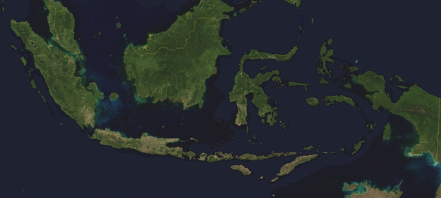
Satellite image of Indonesia in August 2004. Border to East Timor is missing.
Screenshot from NASA World Wind, Blue Marble Next-Generation layer.
Historial del fitxer
Cliqueu una data/hora per veure el fitxer tal com era aleshores.
| Data/hora | Miniatura | Dimensions | Usuari/a | Comentari | |
|---|---|---|---|---|---|
| actual | 15:14, 16 ago 2013 | | 3.803 × 1.703 (5,3 Mo) | Ciaurlec | Enanched contrast and brightness |
| 17:39, 23 abr 2006 |  | 3.803 × 1.703 (5 Mo) | Hautala | {{PD-WorldWind}} Satellite image of Indonesia in August 2004. Border to East Timor is missing. Screenshot from NASA World Wind, Blue Marble Next-Generation layer. Category:Satellite pictures of Indonesia |
Ús del fitxer
No hi ha pàgines que utilitzin aquest fitxer.
Ús global del fitxer
Utilització d'aquest fitxer en altres wikis:
- Utilització a af.wikipedia.org
- Utilització a de.wiktionary.org
- Utilització a en.wikipedia.org
- Utilització a map-bms.wikipedia.org
- Utilització a pl.wikipedia.org
- Utilització a pt.wikipedia.org