Fitxer:Jewel-Toned Lakes of the Qinghai-Tibet Plateau.jpg

Mida d'aquesta previsualització: 615 × 600 píxels. Altres resolucions: 246 × 240 píxels | 492 × 480 píxels | 788 × 768 píxels | 1.050 × 1.024 píxels | 2.101 × 2.048 píxels | 7.940 × 7.740 píxels.
Fitxer original (7.940 × 7.740 píxels, mida del fitxer: 7 Mo, tipus MIME: image/jpeg)
| Aquest fitxer i la informació mostrada a continuació provenen del dipòsit multimèdia lliure Wikimedia Commons. |
| Atenció | El fitxer original té una quantitat elevada de píxels; si l’obriu a resolució plena, és possible que no es carregui correctament o provoqui que el vostre navegador es bloqui. Feu servir el ZoomViewer per a evitar aquests problemes. |
|---|
Resum
| Descripció |
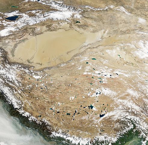
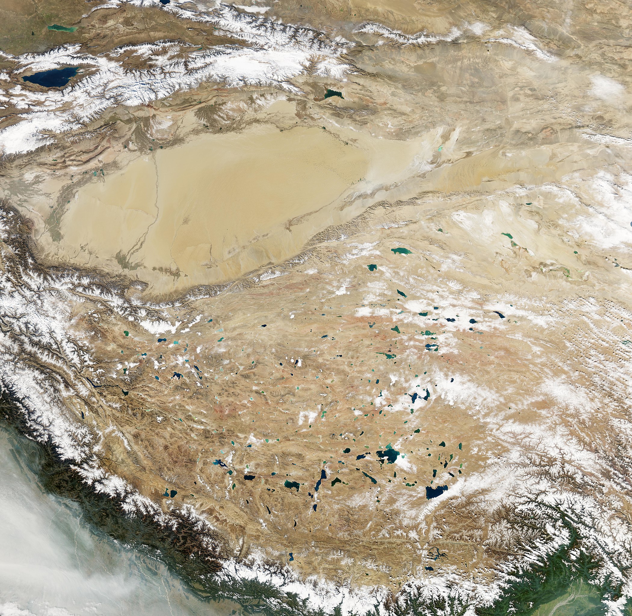
English: Natural-colour image of the Tibetan Plateau. The Qinghai-Tibet Plateau not only gives rise to most of Asia’s major rivers, it also holds a constellation of salt- and freshwater lakes. Due to differences in depth, sediments, and microscopic organisms in the various lakes, they collectively present a myriad of greens, blues, and teals when viewed from above. Resembling bits of abalone shell, the lakes glimmer in assorted jewel tones. The lakes in this region typically lack outlets, allowing the accumulation of minerals that, combined with other features, influence lake colour. The lakes vary widely in surface area and shape. Two of the largest in this scene are Siling Co and Nam Co. One of the most irregularly shaped lakes is Ngangla Ringco.
Nam Co ranks among the world’s highest-altitude salt lakes, with a lake surface at 4,718 meters. It measures roughly 79 by 25 kilometres and, except for areas along the south-western and north-eastern margins, the lake appears nearly uniform blue. Siling Co’s shape and colour vary more than Nam Co’s. The lake’s blue-green hue ranges from light (in the north and east) to dark (in the south and west). Fringing the lake are smaller water bodies, which all used to be part of a larger lake. Lying to the west, Ngangla Ringco is one of the most unusually shaped water bodies on the Qinghai-Tibet Plateau, with colours ranging from turquoise to sapphire. Small islands dot the surface in the west, and a large island sits in the lake’s eastern half. |
| Data | |
| Font | NASA Earth Observatory |
| Autor | Jesse Allen |
Image captured by the Moderate Resolution Imaging Spectroradiometer (MODIS) on NASA’s Aqua satellite. Data obtained from the Goddard Level 1 and Atmospheric Archive and Distribution System (LAADS).
Llicència
| Aquest fitxer és en el domini públic perquè ha estat creat per la NASA. L'avís legal de la NASA diu que «el material de la NASA no està protegit per copyright si no es diu el contrari». (NASA copyright policy page o JPL Image Use Policy). | ||
 |
Atenció:
|
| Anotacions | Aquesta imatge té anotacions: Vegeu-les a Commons |
Historial del fitxer
Cliqueu una data/hora per veure el fitxer tal com era aleshores.
| Data/hora | Miniatura | Dimensions | Usuari/a | Comentari | |
|---|---|---|---|---|---|
| actual | 15:22, 26 gen 2013 | | 7.940 × 7.740 (7 Mo) | Slick-o-bot | Bot: convert to a non-interlaced jpeg (see bug #17645) |
| 12:33, 26 nov 2010 |  | 7.940 × 7.740 (6,88 Mo) | Originalwana | {{Information |Description={{en|1=Natural-colour image of the Tibetan Plateau. The Qinghai-Tibet Plateau not only gives rise to most of Asia’s major rivers, it also holds a constellation of salt- and freshwater lakes. Due to differences in depth |
Ús del fitxer
La pàgina següent utilitza aquest fitxer:
Ús global del fitxer
Utilització d'aquest fitxer en altres wikis:
- Utilització a ast.wikipedia.org
- Utilització a bo.wikipedia.org
- Utilització a de.wikipedia.org
- Utilització a en.wikipedia.org
- Utilització a es.wikipedia.org
- Utilització a sl.wikipedia.org
- Utilització a sr.wikipedia.org
- Utilització a uk.wikipedia.org