Fitxer:Map Operation Schwarz.JPG

Fitxer original (1.715 × 1.920 píxels, mida del fitxer: 444 Ko, tipus MIME: image/jpeg)
| Aquest fitxer i la informació mostrada a continuació provenen del dipòsit multimèdia lliure Wikimedia Commons. |
Resum
| Descripció |
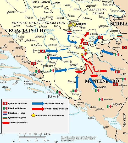
English: Map of Operation Schwarz against yugoslav partisans during II World War. |
|||
| Data | ||||
| Font | Own work, based on File:Bosnia and Hercegovina map.png and this source of information. | |||
| Autor | Cartographer of the United Nations | |||
| Permís (Com reutilitzar aquest fitxer) |
|
|||
| Altres versions |
|


Llicència
- Sou lliure de:
- compartir – copiar, distribuir i comunicar públicament l'obra
- adaptar – fer-ne obres derivades
- Amb les condicions següents:
- reconeixement – Heu de donar la informació adequada sobre l'autor, proporcionar un enllaç a la llicència i indicar si s'han realitzat canvis. Podeu fer-ho amb qualsevol mitjà raonable, però de cap manera no suggereixi que l'autor us dóna suport o aprova l'ús que en feu.
Historial del fitxer
Cliqueu una data/hora per veure el fitxer tal com era aleshores.
| Data/hora | Miniatura | Dimensions | Usuari/a | Comentari | |
|---|---|---|---|---|---|
| actual | 09:41, 5 ago 2012 | | 1.715 × 1.920 (444 Ko) | Rowanwindwhistler | Maps are not the same, the original has a Spanish legend needed for the Spanish article, please upload the English version a separate file. If the original file contains any mistake, please state it in the discussion page so that it can be corrected. T... |
| 11:34, 8 juny 2012 |  | 1.715 × 1.920 (1,26 Mo) | DIREKTOR | fixup | |
| 03:04, 15 des 2010 |  | 1.715 × 1.920 (444 Ko) | Goldorak | {{Information |Description={{en|1=Map of Operation Schwarz against yugoslav partisans during II World War.}} |Source=Own work, based on File:Bosnia and Hercegovina map.png |Author=Cartographer of the United Nations |Da |
Ús del fitxer
La pàgina següent utilitza aquest fitxer:
Ús global del fitxer
Utilització d'aquest fitxer en altres wikis:
- Utilització a de.wikipedia.org
- Utilització a ru.wikipedia.org
- Utilització a sh.wikipedia.org
- Utilització a uk.wikipedia.org
- Utilització a vi.wikipedia.org
- Utilització a www.wikidata.org