Fitxer:Map lubeck 1910.jpg

Fitxer original (1.386 × 1.632 píxels, mida del fitxer: 1,74 Mo, tipus MIME: image/jpeg)
| Aquest fitxer i la informació mostrada a continuació provenen del dipòsit multimèdia lliure Wikimedia Commons. |
Resum
| Descripció |
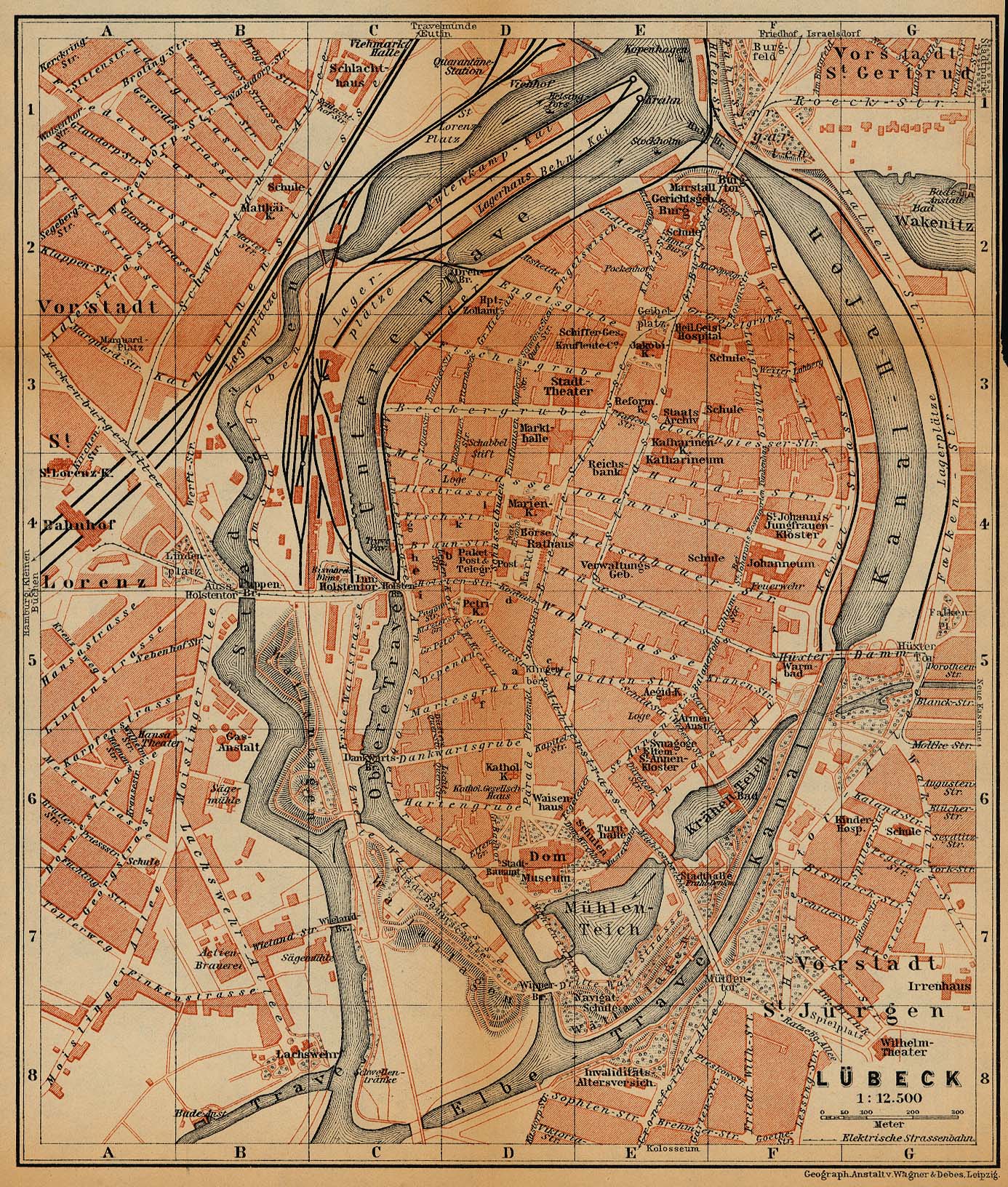
Deutsch: Stadtkarte von Lübeck um 1910 vom Baedeker Verlag
English: City Map of Lübeck, Germany, 1910, by Baedeker |
| Data | |
| Font | http://www.lib.utexas.edu/maps/historical/baedeker_n_germany_1910/lubeck_1910.jpg |
| Autor | "Northern Germany as far as the Bavarian and Austrian Frontiers; Handbook for Travellers" by Karl Baedeker. Fifteenth Revised Edition. Leipzig, Karl Baedeker; New York, Charles Scribner's Sons 1910. |
| Permís (Com reutilitzar aquest fitxer) |
"Courtesy of the University of Texas Libraries, The University of Texas at Austin." http://www.lib.utexas.edu/maps/map_sites/hist_sites.html |
| Altres versions |
original is a duplicate of File:Lubeck 1910.jpg |

Llicència
|
Aquest material està en domini públic als Estats Units i als altres països on el dret d'autor s'estén per 70 anys (o menys) després de la mort de l'autor.
| |
| Aquest fitxer està identificat com a lliure de restriccions conegudes sota la llei de drets d'autor, inclosos els drets veïns. | |
⧼Abusefilter-links⧽
Historial del fitxer
Cliqueu una data/hora per veure el fitxer tal com era aleshores.
| Data/hora | Miniatura | Dimensions | Usuari/a | Comentari | |
|---|---|---|---|---|---|
| actual | 16:14, 20 feb 2019 | | 1.386 × 1.632 (1,74 Mo) | 1970gemini | entschleiert |
| 01:20, 27 maig 2006 |  | 1.386 × 1.632 (876 Ko) | 700 MB | even more | |
| 00:53, 27 maig 2006 |  | 1.386 × 1.632 (1,15 Mo) | 700 MB | tried to remove the stain | |
| 03:56, 23 abr 2006 |  | 1.386 × 1.632 (810 Ko) | 700 MB | {{Information| |Description=City Map of Lübeck, Germany, 1910 |Source=http://www.lib.utexas.edu/maps/historical/baedeker_n_germany_1910/lubeck_1910.jpg |Date=1910 |Author="Northern Germany as far as the Bavarian and Austrian Frontiers; Handbook for Trave |
Ús del fitxer
La pàgina següent utilitza aquest fitxer:
Ús global del fitxer
Utilització d'aquest fitxer en altres wikis:
- Utilització a azb.wikipedia.org
- Utilització a de.wikipedia.org
- Utilització a he.wikipedia.org
- Utilització a pl.wikipedia.org