Fitxer:Mount Tambora Volcano, Sumbawa Island, Indonesia.jpg

Fitxer original (4.256 × 2.828 píxels, mida del fitxer: 2,29 Mo, tipus MIME: image/jpeg)
| Aquest fitxer i la informació mostrada a continuació provenen del dipòsit multimèdia lliure Wikimedia Commons. |
Resum
| Descripció |
Bahasa Indonesia: Foto astronot ini menggambarkan kaldera puncak gunung Tambora. Kaldera ini berdiameter 6 km dan terbentuk dengan dalam 1.100 m ketika puncak Gunung Tambora yang berketinggian kira-kira 4.000 m telah tidak ada, dan ruangan magma di bawahnya menjadi kosong setelah letusan tahun 1815. Saat ini dasar kawah menjadi lokasi sebuah danau air tawar musiman, deposit sedimen yang belum lama, aliran lava kecil, dan kubah yang terbentuk selama abad kesembilan belas dan kedua puluh. Deposit tephra yang berlapis terlihat di sepanjang sisi barat laut bibir kawah. Fumarol aktif, atau ventilasi uap, masih ada di kaldera.
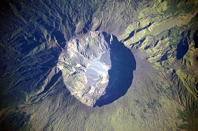
English: This detailed astronaut photograph depicts the summit caldera of the volcano. The huge caldera—6 kilometers in diameter and 1,100 meters deep—formed when Tambora’s estimated 4,000-meter-high peak was removed, and the magma chamber below emptied during the 1815 eruption. Today the crater floor is occupied by an ephemeral freshwater lake, recent sedimentary deposits, and minor lava flows and domes emplaced during the nineteenth and twentieth centuries. Layered tephra deposits are visible along the north-western crater rim. Active fumaroles, or steam vents, still exist in the caldera.
Français : Photographie de la caldera sommitale du mont Tambora, en Indonésie. Cette caldera est immense, avec 6 km de diamètre et 1000 m de profondeur. Sa formation date de l'éruption de 1815, qui est l'éruption volcanique la plus importante de l'histoire. Avant l'éruption, le Tambora formait un pic d'une altitude d'environ 4000 m. Aujourd'hui, les lèvres de la caldera sont à 2500 m d'altitude. Le fond de la caldera est occupé par un lac temporaire, des coulées de laves provenant d'éruptions mineures et des fumeroles.
Deutsch: Krater des Tambora
Русский: Эта фотография подробно показывает кальдеру вулкана Тамбора, имеющую 6 — 7 километров в диаметре. Она образовалась в результате катастрофического извержения 1815 года, когда верхняя часть вулкана обрушилась из-за опустения магматической камеры под ним. Сегодня внутри кальдеры находится небольшое пресноводное озеро, лавовые купола, а в северо-западной части кратера имеются многослойные отложения тефры. Кроме того кальдере присуща фумарольная активность.
|
||||||||||||||||||||||||||||||||||||||||||||||||||||||
| Data | Published 2009-07-19. Taken 2009-03-06. | ||||||||||||||||||||||||||||||||||||||||||||||||||||||
| Font | Image and and English description: Mount Tambora Volcano, Sumbawa Island, Indonesia, NASA Earth Observatory. 2nd version: Transferred from de.wikipedia to Commons.; originally from https://eol.jsc.nasa.gov/SearchPhotos/photo.pl?mission=ISS020&roll=E&frame=06563 | ||||||||||||||||||||||||||||||||||||||||||||||||||||||
| Autor | This image was taken by the NASA Expedition 20 crew. | ||||||||||||||||||||||||||||||||||||||||||||||||||||||
| Posició de la càmera | | Aquesta i altres imatges properes a: OpenStreetMap |
|---|
Aquest fitxer ha estat catalogat per Johnson Space Center dels Estats Units d'Amèrica per a l'Administració Nacional d'Aeronàutica i de l'Espai (NASA)en virtut identificat com a: ID del fitxer : ISS020-E-6563.Els ID dels fitxers i ID alternatius són traduïts de Photo ID .Aquesta etiqueta no indica l'estat dels drets d'autor de la imatge carregada. Cal un senyal de drets d'autor. Vegeu Commons:Sobre les llicències. Altres idiomes:
|
|

Llicència
| Aquest fitxer és en el domini públic perquè ha estat creat per la NASA. L'avís legal de la NASA diu que «el material de la NASA no està protegit per copyright si no es diu el contrari». (NASA copyright policy page o JPL Image Use Policy). | ||
 |
Atenció:
|
Original upload log (2nd version)
- 2009-07-23 01:35 Geoethno 1440×960× (469914 bytes) {{Information |Beschreibung = Krater des Tambora |Quelle = http://earthobservatory.nasa.gov/images/imagerecords/39000/39412/ISS020-E-06563_l
Historial del fitxer
Cliqueu una data/hora per veure el fitxer tal com era aleshores.
| Data/hora | Miniatura | Dimensions | Usuari/a | Comentari | |
|---|---|---|---|---|---|
| actual | 14:55, 24 feb 2011 | | 4.256 × 2.828 (2,29 Mo) | Originalwana | higher res |
| 19:37, 15 abr 2010 |  | 1.440 × 960 (619 Ko) | Rosenzweig | Reverted to version as of 11:04, 19 July 2009. Back to Commons version. | |
| 19:37, 15 abr 2010 |  | 1.440 × 960 (459 Ko) | Rosenzweig | different version from de.wp | |
| 13:04, 19 jul 2009 |  | 1.440 × 960 (619 Ko) | Originalwana | {{Information |Description={{en|1=This detailed astronaut photograph depicts the summit caldera of the volcano. The huge caldera—6 kilometres in diameter and 1,100 meters deep—formed when Tambora’s estimated 4,000-meter-high peak was removed, and th |
Ús del fitxer
La pàgina següent utilitza aquest fitxer:
Ús global del fitxer
Utilització d'aquest fitxer en altres wikis:
- Utilització a af.wikipedia.org
- Utilització a ar.wikipedia.org
- Utilització a ast.wikipedia.org
- Utilització a ban.wikipedia.org
- Utilització a be.wikipedia.org
- Utilització a bn.wikipedia.org
- Utilització a cs.wikipedia.org
- Utilització a da.wikipedia.org
- Utilització a de.wikipedia.org
- Utilització a en.wikipedia.org
- Utilització a en.wikiversity.org
- Utilització a en.wikivoyage.org
- Utilització a eo.wikipedia.org
- Utilització a es.wikipedia.org
- Utilització a fa.wikipedia.org
- Utilització a fr.wikipedia.org
- Utilització a fr.wiktionary.org
- Utilització a gl.wikipedia.org
- Utilització a gor.wikipedia.org
- Utilització a he.wikipedia.org
- Utilització a hr.wikipedia.org
- Utilització a id.wikipedia.org
- Gunung Tambora
- Wikipedia:Hari ini dalam sejarah/April
- Wikipedia:Gambar pilihan/2011
- Wikipedia:Gambar pilihan/Usulan/2011/54 Intro
- Wikipedia:Gambar pilihan/54 2011
- Templat:Hari Ini Dalam Sejarah/April
- Wikipedia:Gambar pilihan/Tempat/Landskap
- Wikipedia:Arsip halaman utama/2023/04/10
- Wikipedia:Arsip halaman utama/2024/04/10
- Utilització a it.wikipedia.org
- Utilització a ja.wikipedia.org
- Utilització a ka.wikipedia.org
- Utilització a kk.wikipedia.org
- Utilització a mk.wikipedia.org
- Utilització a ro.wikipedia.org
Vegeu més usos globals d'aquest fitxer.