Fitxer:Nahkealehtinen kasvillisuus.png

Mida d'aquesta previsualització: 800 × 398 píxels. Altres resolucions: 320 × 159 píxels | 640 × 318 píxels | 1.262 × 628 píxels.
Fitxer original (1.262 × 628 píxels, mida del fitxer: 35 Ko, tipus MIME: image/png)
| Aquest fitxer i la informació mostrada a continuació provenen del dipòsit multimèdia lliure Wikimedia Commons. |

|
S'autoritza la còpia, la distribució i la modificació d'aquest document sota els termes de la llicència de documentació lliure GNU versió 1.2 o qualsevol altra versió posterior que publiqui la Free Software Foundation; sense seccions invariants, ni textos de portada, ni textos de contraportada. S'inclou una còpia d'aquesta llicència en la secció titulada GNU Free Documentation License. |
| Aquest fitxer està subjecte a la llicència de Creative Commons Reconeixement i Compartir Igual 3.0 No adaptada. | ||
| Reconeixement: Vzb83 | ||
| ||
| Aquest avís de llicència s'ha afegit a aquest fitxer d'acord amb l'actualització de la llicència GFDL. |
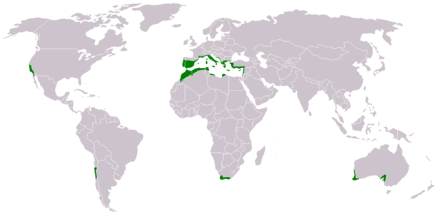
- Suomi: Nahkealehtisen eli välimerenkasvillisuuden levinneisyys.
- English: Distribution of Mediterranean forests, woodlands, and shrub biome.
Based on the blank world map BlankMap-World.png.
See also Image:Medclim.png and Image:Macchia mediterranea map.jpg.
Historial del fitxer
Cliqueu una data/hora per veure el fitxer tal com era aleshores.
| Data/hora | Miniatura | Dimensions | Usuari/a | Comentari | |
|---|---|---|---|---|---|
| actual | 17:34, 17 març 2018 | | 1.262 × 628 (35 Ko) | Maphobbyist | Montenegro border |
| 04:15, 9 jul 2011 |  | 1.262 × 628 (44 Ko) | Maphobbyist | South Sudan has become independent on July 9, 2011. Sudan and South Sudan are shown with the new international border between them. | |
| 18:48, 11 juny 2010 |  | 1.262 × 628 (44 Ko) | Maphobbyist | Little editing | |
| 16:35, 11 juny 2010 |  | 1.262 × 628 (44 Ko) | Maphobbyist | Syria except the Mediterranean coastal area, Jordan, South Israel, Iraq, the Black Sea coast of Turkey and the Caspian Coast of Iran do not have a Mediterranean climate. The northwest coast of Libya including Tripoli,has a Mediterranean climate. | |
| 23:43, 13 feb 2007 |  | 1.262 × 628 (14 Ko) | Hautala | {{GFDL-user-fi|Vzb83}} * {{fi|Nahkealehtisen eli välimerenkasvillisuuden levinneisyys.}} * {{en|Distribution of Mediterranean forests, woodlands, and shrub biome.}} Based on the blank world map Image:BlankMap-World.png. See also [[:Image:Medclim |
Ús del fitxer
Les 2 pàgines següents utilitzen aquest fitxer:
Ús global del fitxer
Utilització d'aquest fitxer en altres wikis:
- Utilització a an.wikipedia.org
- Utilització a ar.wikipedia.org
- Utilització a bs.wikipedia.org
- Utilització a cs.wikipedia.org
- Utilització a da.wikipedia.org
- Utilització a eo.wikipedia.org
- Utilització a eu.wikipedia.org
- Utilització a fi.wikipedia.org
- Utilització a hr.wikipedia.org
- Utilització a ka.wikipedia.org
- Utilització a no.wikipedia.org
- Utilització a pt.wikipedia.org
- Utilització a sh.wikipedia.org
- Utilització a sr.wikipedia.org
- Utilització a zh.wikipedia.org