Fitxer:Quadrangles of Dione (ed. 2011) - PIA12827.jpg
Fitxer original (3.087 × 2.024 píxels, mida del fitxer: 705 Ko, tipus MIME: image/jpeg)
| Aquest fitxer i la informació mostrada a continuació provenen del dipòsit multimèdia lliure Wikimedia Commons. |
_-_PIA12827.jpg?uselang=ca)
Resum
| Descripció |
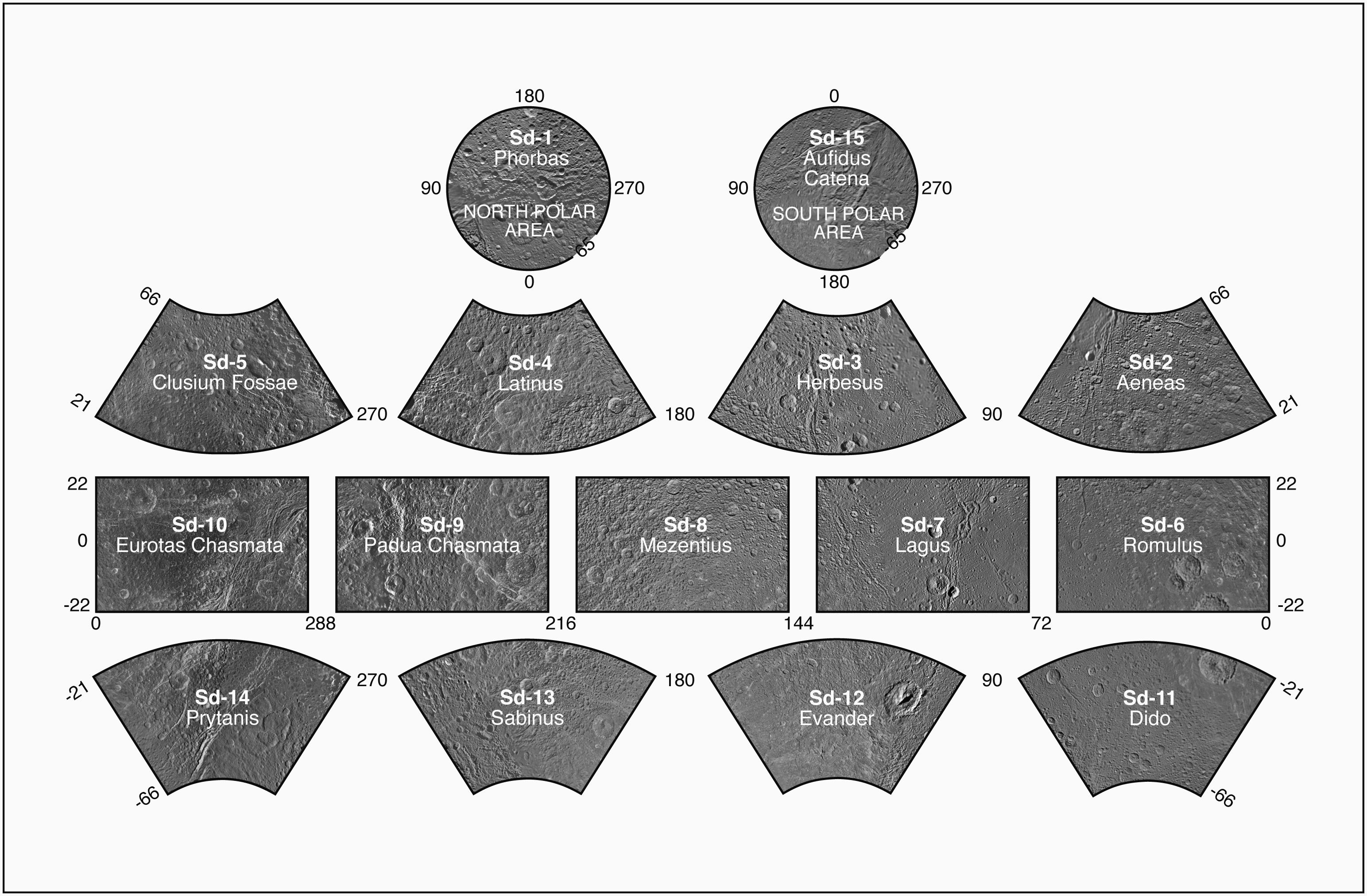
English: Presented here is a complete set of cartographic map sheets from a high-resolution Dione atlas, a project of the Cassini Imaging Team.
The map sheets form a 15-quadrangle series covering the entire surface of Dione at a nominal scale of 1:1,000,000. An index for the atlas is included here, along with an unlabeled version of each terrain section. The map data was acquired by the Cassini imaging experiment. The mean radius of Dione used for projection of the maps is 562.53 kilometers (349.54 miles). Names for features have been approved by the International Astronomical Union (IAU). This atlas is an update to the version released in August 2008 (see PIA08418). The Cassini Solstice Mission is a joint United States and European endeavor. The Jet Propulsion Laboratory, a division of the California Institute of Technology in Pasadena, manages the mission for NASA's Science Mission Directorate, Washington, D.C. The Cassini orbiter was designed, developed and assembled at JPL. The imaging team consists of scientists from the US, England, France, and Germany. The imaging operations center and team lead (Dr. C. Porco) are based at the Space Science Institute in Boulder, Colo. For more information about the Cassini Solstice Mission visit http://ciclops.org, http://www.nasa.gov/cassini and http://saturn.jpl.nasa.gov. Credit: NASA / JPL-Caltech / Space Science Institute Released: September 28, 2011 (PIA 12827) |
| Data | |
| Font | http://photojournal.jpl.nasa.gov/catalog/PIA12827 |
| Autor | NASA/JPL/Space Science Institute |
Llicència
| Aquest fitxer és en el domini públic perquè ha estat creat per la NASA. L'avís legal de la NASA diu que «el material de la NASA no està protegit per copyright si no es diu el contrari». (NASA copyright policy page o JPL Image Use Policy). | ||
 |
Atenció:
|
Historial del fitxer
Cliqueu una data/hora per veure el fitxer tal com era aleshores.
| Data/hora | Miniatura | Dimensions | Usuari/a | Comentari | |
|---|---|---|---|---|---|
| actual | 23:41, 14 gen 2016 | | 3.087 × 2.024 (705 Ko) | Ysogo | Presented here is a complete set of cartographic map sheets from a high-resolution Dione atlas, a project of the Cassini Imaging Team. The map sheets form a 15-quadrangle series covering the entire surface of Dione at a nominal scale of 1:1,000,000. A... |
Ús del fitxer
La pàgina següent utilitza aquest fitxer:
Ús global del fitxer
Utilització d'aquest fitxer en altres wikis:
- Utilització a it.wikipedia.org
_-_PIA12827.jpg)