Fitxer:Sépulture de Teviec (5).jpg
Mida d'aquesta previsualització: 800 × 533 píxels. Altres resolucions: 320 × 213 píxels | 640 × 427 píxels | 1.024 × 683 píxels | 1.280 × 853 píxels | 2.560 × 1.707 píxels | 6.048 × 4.032 píxels.
Fitxer original (6.048 × 4.032 píxels, mida del fitxer: 19,3 Mo, tipus MIME: image/jpeg)
| Aquest fitxer i la informació mostrada a continuació provenen del dipòsit multimèdia lliure Wikimedia Commons. |
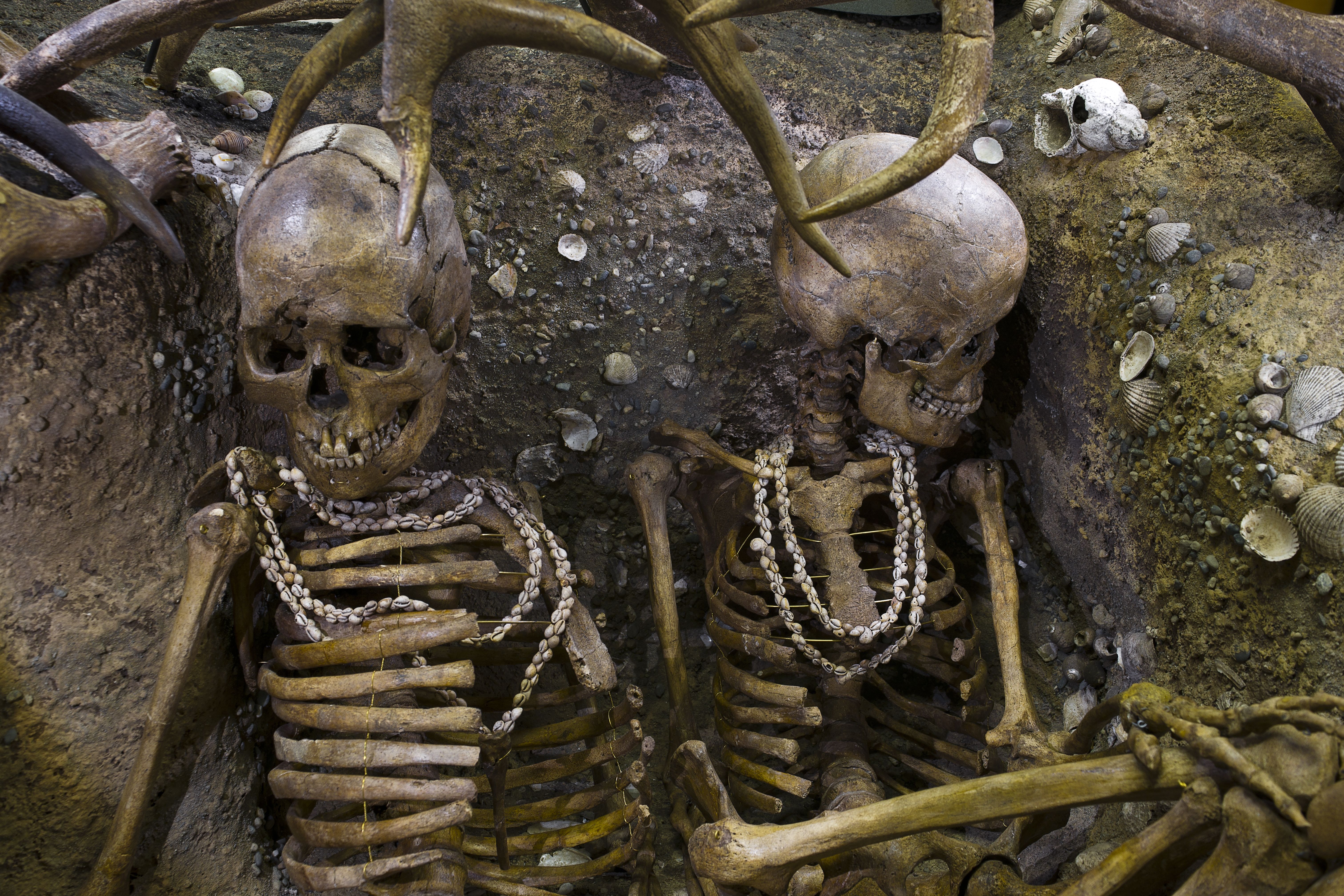
Burial of Teviec, Bretagne, France
Resum
| Descripció |
Tomb of Téviec. Two skeletons of a woman between 25 and 35 years, died a violent death, with several head injuries and impacts of arrows. The two bodies were buried with great care in a pit in the half basement and half in the kitchen debris that covered them. All protected by antler. The grave goods include flint and bone (mainly wild boar) offerings? and funeral jewelry which is made of marine shells drilled and assembled into necklaces, bracelets and ankle rings. Some of them have a few bone objects with engraved lines. Recovery in 1938 restoration 2010. |
|||||||||||||||||||||||
| Data | entre - 6740 i - 5680 aC (Mesolithic) | |||||||||||||||||||||||
| Col·lecció |
|
|||||||||||||||||||||||
| Historial de l'obra |
Lloc del descobriment: Théviec or Téviec, Saint-Pierre-Quiberon, Bretagne, France.. |
|||||||||||||||||||||||
| Origen/Fotògraf |
Didier Descouens, 9 d'octubre de 2010 Jo, el titular dels drets d'autor d'aquest treball, el public sota la següent llicència: This file is licensed under the Creative Commons Attribution-Share Alike 4.0 International license.
|
|||||||||||||||||||||||
| Altres versions |
|
|||||||||||||||||||||||


.jpg)
.jpg?uselang=ca)
| Posició de la càmera | | Aquesta i altres imatges properes a: OpenStreetMap |
|---|
.jpg¶ms=043.593897_N_0001.449230_E_globe:Earth_type:camera__&language=ca)

|
This document was made as part of the Projet Phoebus.
|
Published in the press
Historial del fitxer
Cliqueu una data/hora per veure el fitxer tal com era aleshores.
| Data/hora | Miniatura | Dimensions | Usuari/a | Comentari | |
|---|---|---|---|---|---|
| actual | 18:23, 9 oct 2010 | | 6.048 × 4.032 (19,3 Mo) | Archaeodontosaurus | {{Information |Description={{en|1=x}} |Source={{own}} |Author=Archaeodontosaurus |Date= |Permission= |other_versions= }} |
Ús del fitxer
La pàgina següent utilitza aquest fitxer:
Ús global del fitxer
Utilització d'aquest fitxer en altres wikis:
- Utilització a ba.wikipedia.org
- Utilització a be.wikipedia.org
- Utilització a bg.wikipedia.org
- Utilització a br.wikipedia.org
- Utilització a ceb.wikipedia.org
- Utilització a cs.wikipedia.org
- Utilització a cy.wikipedia.org
- Utilització a da.wikipedia.org
- Utilització a de.wikipedia.org
- Utilització a el.wikipedia.org
- Utilització a en.wikipedia.org
- Utilització a fa.wikipedia.org
- Utilització a fr.wikipedia.org
- Utilització a gl.wikipedia.org
- Utilització a hi.wikipedia.org
- Utilització a hr.wikipedia.org
- Utilització a hu.wikipedia.org
- Utilització a id.wikipedia.org
- Utilització a it.wikipedia.org
- Utilització a ja.wikipedia.org
- Utilització a ka.wikipedia.org
- Utilització a kk.wikipedia.org
- Utilització a ko.wikipedia.org
- Utilització a lt.wikipedia.org
- Utilització a mk.wikipedia.org
- Utilització a ms.wikipedia.org
- Utilització a ne.wikipedia.org
- Utilització a nl.wikipedia.org
- Utilització a ru.wikipedia.org
- Utilització a sh.wikipedia.org
- Utilització a simple.wikipedia.org
- Utilització a sl.wikipedia.org
- Utilització a sv.wikipedia.org
- Utilització a tr.wikipedia.org
- Utilització a uk.wikipedia.org
- Utilització a vls.wikipedia.org
- Utilització a xmf.wikipedia.org
- Utilització a zh.wikipedia.org
.jpg)