Fitxer:Snake River watershed map.png

Mida d'aquesta previsualització: 649 × 600 píxels. Altres resolucions: 260 × 240 píxels | 520 × 480 píxels | 831 × 768 píxels | 1.211 × 1.119 píxels.
Fitxer original (1.211 × 1.119 píxels, mida del fitxer: 2,1 Mo, tipus MIME: image/png)
| Aquest fitxer i la informació mostrada a continuació provenen del dipòsit multimèdia lliure Wikimedia Commons. |
Resum
| Descripció |
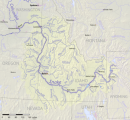
English: Map of the Snake River watershed, USA. Intended to replace older File:SnakeRiverNicerMap.jpg. Created using public domain USGS National Map data. |
| Data | |
| Font | Treball propi |
| Autor | Shannon1 |
Llicència
Jo, el titular dels drets d'autor d'aquest treball, el public sota les següents llicències:

|
S'autoritza la còpia, la distribució i la modificació d'aquest document sota els termes de la llicència de documentació lliure GNU versió 1.2 o qualsevol altra versió posterior que publiqui la Free Software Foundation; sense seccions invariants, ni textos de portada, ni textos de contraportada. S'inclou una còpia d'aquesta llicència en la secció titulada GNU Free Documentation License. |
This file is licensed under the Creative Commons Attribution-Share Alike Attribution-Share Alike 4.0 International, 3.0 Unported, 2.5 Generic, 2.0 Generic and 1.0 Generic license.
- Sou lliure de:
- compartir – copiar, distribuir i comunicar públicament l'obra
- adaptar – fer-ne obres derivades
- Amb les condicions següents:
- reconeixement – Heu de donar la informació adequada sobre l'autor, proporcionar un enllaç a la llicència i indicar si s'han realitzat canvis. Podeu fer-ho amb qualsevol mitjà raonable, però de cap manera no suggereixi que l'autor us dóna suport o aprova l'ús que en feu.
- compartir igual – Si modifiqueu, transformeu, o generareu amb el material, haureu de distribuir les vostres contribucions sota una llicència similar o una de compatible com l'original
Podeu seleccionar la llicència que vulgueu.
Historial del fitxer
Cliqueu una data/hora per veure el fitxer tal com era aleshores.
| Data/hora | Miniatura | Dimensions | Usuari/a | Comentari | |
|---|---|---|---|---|---|
| actual | 04:45, 9 set 2017 | | 1.211 × 1.119 (2,1 Mo) | Shannon1 | {{Information |Description ={{en|1=Map of the Snake River watershed, USA. Intended to replace older File:SnakeRiverNicerMap.jpg. Created using public domain USGS National Map data.}} |Source =Own work |Author =[[User:Shannon1|Sh... |
Ús del fitxer
La pàgina següent utilitza aquest fitxer:
Ús global del fitxer
Utilització d'aquest fitxer en altres wikis:
- Utilització a af.wikipedia.org
- Utilització a azb.wikipedia.org
- Utilització a be.wikipedia.org
- Utilització a bg.wikipedia.org
- Utilització a ceb.wikipedia.org
- Utilització a cs.wikipedia.org
- Utilització a de.wikipedia.org
- Utilització a el.wikipedia.org
- Utilització a en.wikipedia.org
- Utilització a es.wikipedia.org
- Idaho
- Oregón
- Washington (estado)
- Boise
- Río Snake
- Pocatello (Idaho)
- Río Raft
- Río Portneuf
- Río Clearwater (Idaho)
- Río Boise
- Río Owyhee
- Baker City
- Ontario (Oregón)
- Vale (Oregón)
- Owyhee (Nevada)
- American Falls (Idaho)
- Ammon (Idaho)
- Blackfoot (Idaho)
- Jackson (Wyoming)
- Buhl (Idaho)
- Burley (Idaho)
- Emmett (Idaho)
- Homedale (Idaho)
- Idaho Falls
- McCall (Idaho)
- Meridian (Idaho)
- Mountain Home (Idaho)
- Nampa (Idaho)
- Rexburg
Vegeu més usos globals d'aquest fitxer.