Fitxer:States of Germany coded.svg

Mida d'aquesta previsualització PNG del fitxer SVG: 443 × 599 píxels. Altres resolucions: 177 × 240 píxels | 355 × 480 píxels | 567 × 768 píxels | 757 × 1.024 píxels | 1.513 × 2.048 píxels | 592 × 801 píxels.
Fitxer original (fitxer SVG, nominalment 592 × 801 píxels, mida del fitxer: 118 Ko)
| Aquest fitxer i la informació mostrada a continuació provenen del dipòsit multimèdia lliure Wikimedia Commons. |
Resum
| Descripció |
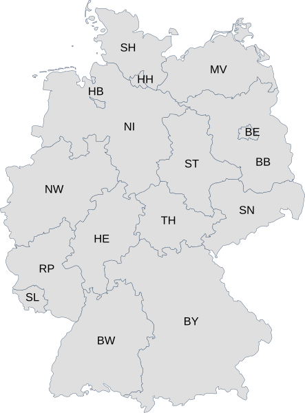
English: Map of Germany with each state labelled with its ISO 3166-2 subcode.
Deutsch: Karte von Deutschland mit den Codes der Bundesländer nach ISO 3166-2:DE |
| Data | |
| Font | File:Karte Bundesrepublik Deutschland.svg and File:Linke Landtage.svg |
| Autor | User:David Liuzzo and User:Voland77 |
Llicència
Aquest fitxer està subjecte a la llicència de Creative Commons Reconeixement 3.0 No adaptada.
- Sou lliure de:
- compartir – copiar, distribuir i comunicar públicament l'obra
- adaptar – fer-ne obres derivades
- Amb les condicions següents:
- reconeixement – Heu de donar la informació adequada sobre l'autor, proporcionar un enllaç a la llicència i indicar si s'han realitzat canvis. Podeu fer-ho amb qualsevol mitjà raonable, però de cap manera no suggereixi que l'autor us dóna suport o aprova l'ús que en feu.
Historial del fitxer
Cliqueu una data/hora per veure el fitxer tal com era aleshores.
| Data/hora | Miniatura | Dimensions | Usuari/a | Comentari | |
|---|---|---|---|---|---|
| actual | 08:34, 26 març 2009 | | 592 × 801 (118 Ko) | Chanheigeorge | {{Information |Description=Map of Germany with each state labelled with its ISO 3166-2 subcode. |Source=File:Karte Bundesrepublik Deutschland.svg and File:Linke Landtage.svg |Date=2009-03-26 |Author=User:David Liuzzo and User:Voland77 |Per |
Ús del fitxer
La pàgina següent utilitza aquest fitxer:
Ús global del fitxer
Utilització d'aquest fitxer en altres wikis:
- Utilització a af.wikipedia.org
- Utilització a bs.wikipedia.org
- Utilització a cs.wikipedia.org
- Utilització a de.wikipedia.org
- Utilització a en.wikipedia.org
- Utilització a eo.wikipedia.org
- Utilització a fo.wikipedia.org
- Utilització a frr.wikipedia.org
- Utilització a id.wikipedia.org
- Utilització a ka.wikipedia.org
- Utilització a ku.wikipedia.org
- Utilització a no.wikipedia.org
- Utilització a pl.wiktionary.org
- Utilització a pt.wikipedia.org
- Utilització a roa-tara.wikipedia.org
- Utilització a ru.wikipedia.org
- Utilització a sv.wikipedia.org
- Utilització a tr.wikipedia.org
- Utilització a vi.wikipedia.org
- Utilització a zh-min-nan.wikipedia.org
- Utilització a zh.wikipedia.org