Fitxer:Sudan political map 2000.jpg
No hi ha cap versió amb una resolució més gran.
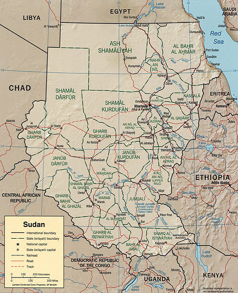
Sudan_political_map_2000.jpg (487 × 599 píxels, mida del fitxer: 342 Ko, tipus MIME: image/jpeg)
| Aquest fitxer i la informació mostrada a continuació provenen del dipòsit multimèdia lliure Wikimedia Commons. |
CIA map of Sudan from 2000
http://hdl.loc.gov/loc.gmd/g8310.ct001564

|
This map is available from the United States Library of Congress's Geography & Map Division
under the digital ID g8310.ct001564. This tag does not indicate the copyright status of the attached work. A normal copyright tag is still required. See Commons:Licensing.
|
| This image is a work of a Central Intelligence Agency employee, taken or made as part of that person's official duties. As a Work of the United States Government, this image or media is in the public domain in the United States.
|

|
Historial del fitxer
Cliqueu una data/hora per veure el fitxer tal com era aleshores.
| Data/hora | Miniatura | Dimensions | Usuari/a | Comentari | |
|---|---|---|---|---|---|
| actual | 12:04, 2 feb 2017 | | 487 × 599 (342 Ko) | عادل | borders correction |
| 03:18, 25 oct 2005 |  | 1.626 × 2.000 (1,84 Mo) | Brian0918 | ||
| 02:08, 10 jul 2005 |  | 1.050 × 1.328 (210 Ko) | Renamed user ixgysjijel | Political map of Sudan from 2000, from http://www.lib.utexas.edu/maps/africa/sudan_pol00.jpg {{PD}} |
Ús del fitxer
La pàgina següent utilitza aquest fitxer:
Ús global del fitxer
Utilització d'aquest fitxer en altres wikis:
- Utilització a am.wikipedia.org
- Utilització a ar.wikipedia.org
- Utilització a azb.wikipedia.org
- Utilització a el.wikipedia.org
- Utilització a en.wikipedia.org
- Utilització a eo.wikipedia.org
- Utilització a es.wikipedia.org
- Utilització a fa.wikipedia.org
- Utilització a fi.wikipedia.org
- Utilització a fr.wikipedia.org
- Utilització a he.wikipedia.org
- Utilització a it.wikipedia.org
- Utilització a ja.wikipedia.org
- Utilització a ko.wikipedia.org
- Utilització a pt.wikipedia.org
- Utilització a ro.wikipedia.org
- Utilització a sw.wikipedia.org
- Utilització a tr.wiktionary.org