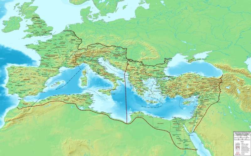
Fitxer:The Roman Empire ca 400 AD.png

Mida d'aquesta previsualització: 800 × 496 píxels. Altres resolucions: 320 × 198 píxels | 640 × 397 píxels | 1.024 × 635 píxels | 1.280 × 793 píxels | 2.560 × 1.587 píxels | 4.339 × 2.689 píxels.
Fitxer original (4.339 × 2.689 píxels, mida del fitxer: 12,8 Mo, tipus MIME: image/png)
Historial del fitxer
Cliqueu una data/hora per veure el fitxer tal com era aleshores.
| Data/hora | Miniatura | Dimensions | Usuari/a | Comentari | |
|---|---|---|---|---|---|
| actual | 00:27, 20 feb 2015 |  | 4.339 × 2.689 (12,8 Mo) | Cplakidas | added potential location of Valentia beyond Hadrian's Wall, removed provincial boundaries in Britannia as too tentative |
| 15:03, 21 jul 2011 |  | 4.339 × 2.689 (10,9 Mo) | Cplakidas | fixed Persian border, differentiated between Eastern and Western empire, different borders for praet. prefectures | |
| 04:37, 21 març 2009 |  | 4.475 × 2.600 (9,99 Mo) | Cplakidas | minor corrections | |
| 14:30, 29 maig 2008 |  | 3.800 × 2.370 (8,1 Mo) | Cplakidas | ||
| 14:17, 29 maig 2008 |  | 4.560 × 2.850 (11,22 Mo) | Cplakidas | clearer version & addition of the Armenian satrapies | |
| 04:02, 30 des 2007 |  | 3.380 × 2.120 (5,96 Mo) | Cplakidas | added names of dioceses, legend box, various minor adjustments | |
| 16:27, 13 des 2007 |  | 3.550 × 2.200 (6,65 Mo) | Cplakidas | new improved version made with Inkscape, slight corrections in borders, added several cities in Africa & Spain | |
| 21:27, 12 nov 2007 |  | 3.550 × 2.200 (4,75 Mo) | Cplakidas | minor corrections in southern Gaul | |
| 14:58, 5 nov 2007 |  | 3.550 × 2.200 (4,75 Mo) | Cplakidas | New version, with some corrections & additions | |
| 18:55, 31 oct 2007 |  | 3.436 × 2.142 (4,5 Mo) | Cplakidas | {{Information |Description=Map of the Roman Empire ca. 400 AD, showing the administrative division into dioceses and provinces, as well as the major cities. The demarcation between Eastern and Western Empires is noted in red. |Source=Base map found at |
Ús del fitxer
Les 2 pàgines següents utilitzen aquest fitxer:
Ús global del fitxer
Utilització d'aquest fitxer en altres wikis:
- Utilització a af.wikipedia.org
- Utilització a ar.wikipedia.org
- Utilització a ary.wikipedia.org
- Utilització a ast.wikipedia.org
- Utilització a bg.wikipedia.org
- Utilització a bn.wikipedia.org
- Utilització a ceb.wikipedia.org
- Utilització a cs.wikipedia.org
- Utilització a de.wikipedia.org
- Utilització a el.wikipedia.org
- Utilització a en.wikipedia.org
- Utilització a eo.wikipedia.org
- Utilització a es.wikipedia.org
- Utilització a et.wikipedia.org
- Utilització a fr.wikipedia.org
- Utilització a he.wikipedia.org
- Utilització a hi.wikipedia.org
- Utilització a hr.wikipedia.org
- Utilització a hu.wikipedia.org
- Utilització a id.wikipedia.org
- Utilització a it.wikipedia.org
- Utilització a ko.wikipedia.org
- Utilització a la.wikipedia.org
- Utilització a lt.wikipedia.org
- Utilització a nl.wikipedia.org
Vegeu més usos globals d'aquest fitxer.


