Fitxer:Trafalgar 1200hr.gif
Mida d'aquesta previsualització: 635 × 600 píxels. Altres resolucions: 254 × 240 píxels | 508 × 480 píxels | 900 × 850 píxels.
Fitxer original (900 × 850 píxels, mida del fitxer: 30 Ko, tipus MIME: image/gif)
| Aquest fitxer i la informació mostrada a continuació provenen del dipòsit multimèdia lliure Wikimedia Commons. |

|
Aquest fitxer ha estat substituït per File:Trafalgar 1200hr.svg. Es recomana utilitzar l'altre. Tingueu en compte que per suprimir imatges substituïdes cal consens. Motiu: "The new file is SVG, and has less spelling mistakes"
|

|
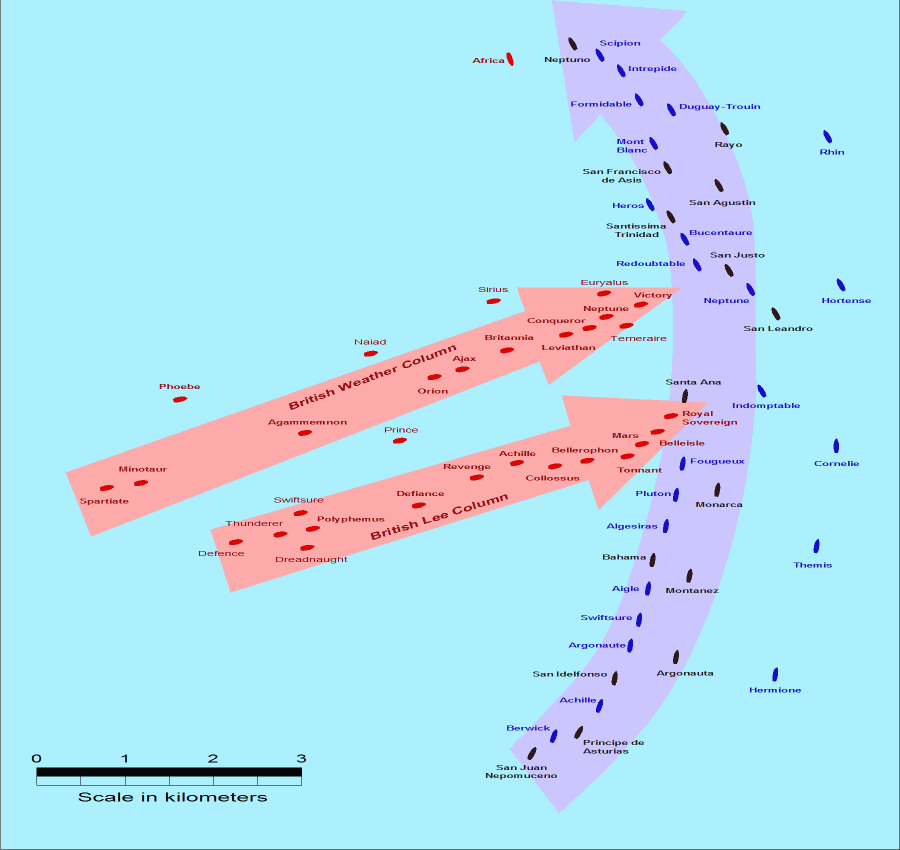
- Description: This map of the Battle of Trafalgar shows the approximate position of the two fleets at 1200 hours during the battle as the Royal Sovereign was breaking into the Franco-Spanish line. North is to the top, and Cape Trafalgar is 10 miles to the northeast.
- Size: 900 × 850 pixels.
- Source: This drawing is based on an illustration in issue number 84 of the Strategy & Tactics magazine The map was made by RJHall using the Campaign Cartographer drawing program, and the image was reduced in size 50% in Paint Shop Pro. Ship icons are not to scale.
Aquest fitxer està publicat sota la llicència de Creative Commons Reconeixement i Compartir Igual 2.5 Genèrica.
- Sou lliure de:
- compartir – copiar, distribuir i comunicar públicament l'obra
- adaptar – fer-ne obres derivades
- Amb les condicions següents:
- reconeixement – Heu de donar la informació adequada sobre l'autor, proporcionar un enllaç a la llicència i indicar si s'han realitzat canvis. Podeu fer-ho amb qualsevol mitjà raonable, però de cap manera no suggereixi que l'autor us dóna suport o aprova l'ús que en feu.
- compartir igual – Si modifiqueu, transformeu, o generareu amb el material, haureu de distribuir les vostres contribucions sota una llicència similar o una de compatible com l'original
Historial del fitxer
Cliqueu una data/hora per veure el fitxer tal com era aleshores.
| Data/hora | Miniatura | Dimensions | Usuari/a | Comentari | |
|---|---|---|---|---|---|
| actual | 16:30, 28 jul 2005 | | 900 × 850 (30 Ko) | RJHall | Battle of Trafalgar situation at 1200hr, 21 October 1805. |
Ús del fitxer
No hi ha pàgines que utilitzin aquest fitxer.
Ús global del fitxer
Utilització d'aquest fitxer en altres wikis:
- Utilització a fr.wikipedia.org
- Utilització a ja.wikipedia.org