Fitxer:USGS Kīlauea image-409.jpg

Mida d'aquesta previsualització: 776 × 600 píxels. Altres resolucions: 311 × 240 píxels | 621 × 480 píxels | 994 × 768 píxels | 1.280 × 989 píxels | 2.560 × 1.978 píxels | 3.300 × 2.550 píxels.
Fitxer original (3.300 × 2.550 píxels, mida del fitxer: 3,98 Mo, tipus MIME: image/jpeg)
| Aquest fitxer i la informació mostrada a continuació provenen del dipòsit multimèdia lliure Wikimedia Commons. |
Resum
| Descripció |
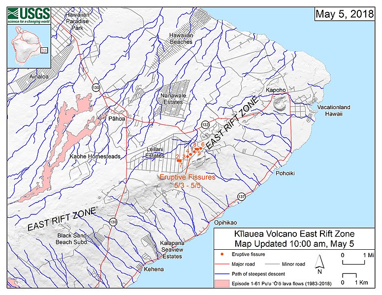
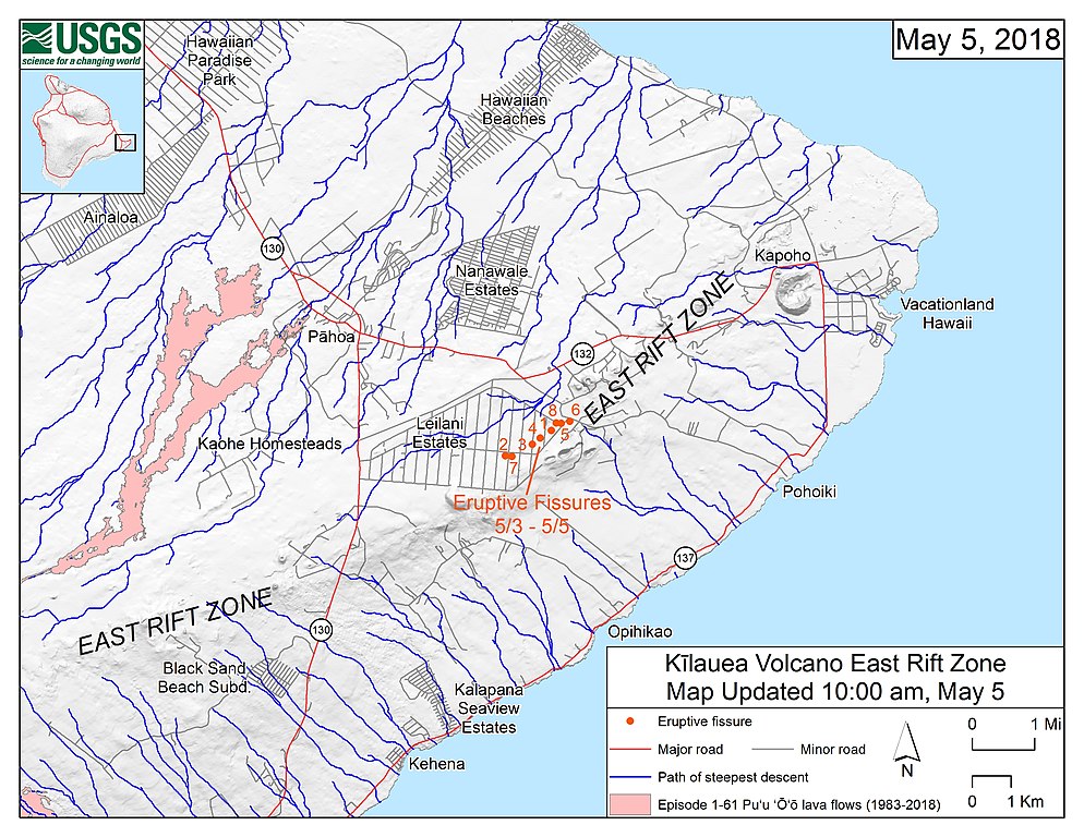
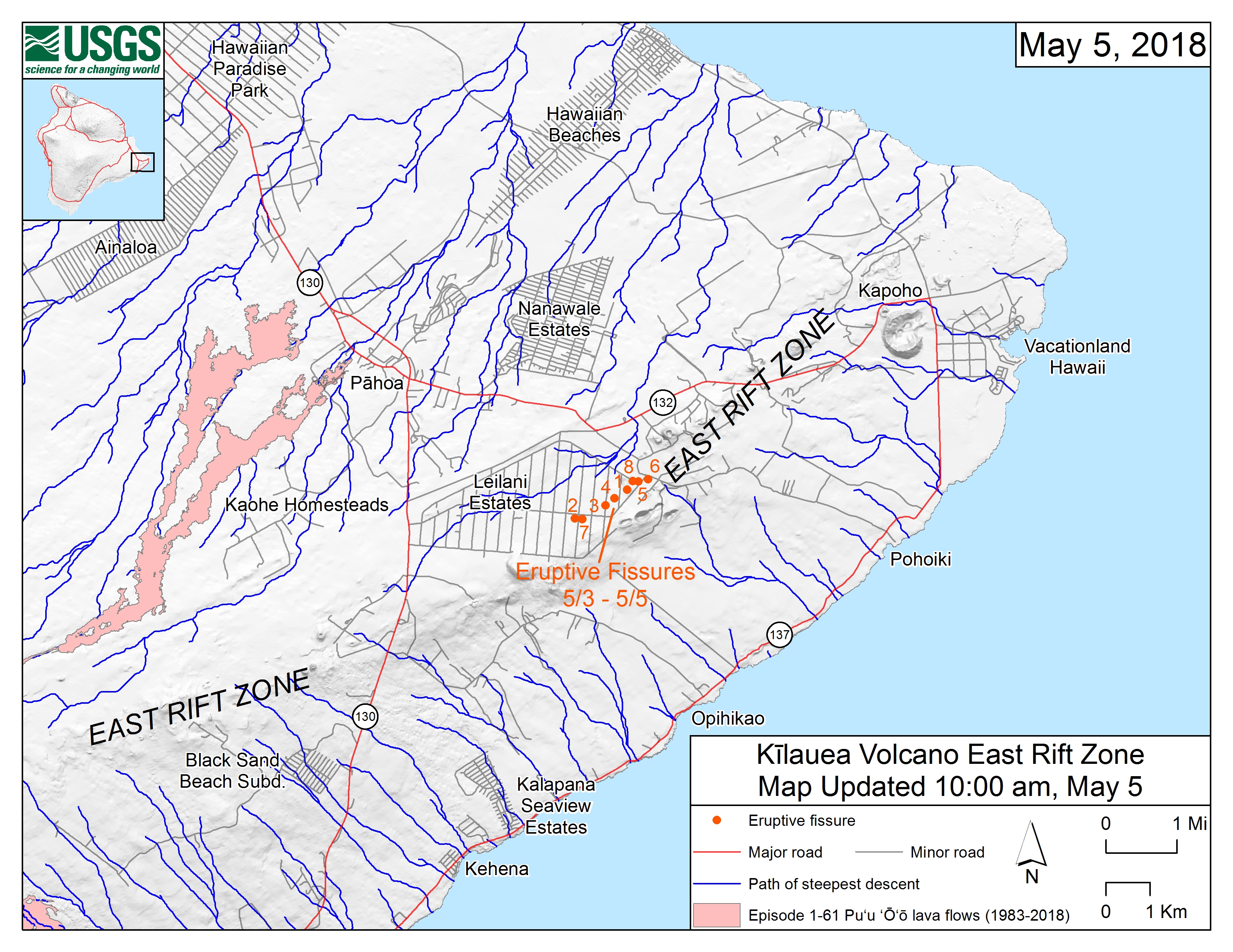
English: Map of the locations of eruptive fissures and the steepest descent paths in area of eruptive fissures, Kīlauea East Rift Zone; 10:00 a.m. HST (May 5, 2018) This map shows the locations of eruptive fissures in the order that they occurred in the Leilani Estates Subdivision as of 10:00 a.m. HST (May 5, 2018). The blue lines are paths of steepest descent that identify likely paths of a lava flow, if and when lava moves downhill from an erupting vent. The paths of steepest-descent were calculated from a 1983 digital elevation model (DEM) of the Island of Hawai‘i, created from digitized contours. Steepest-descent path analysis is based on the assumption that the DEM perfectly represents the earth's surface. DEMs, however, are not perfect, so the blue lines on this map can be used to infer only approximate lava-flow paths. The base shaded-relief map was made from the 1983 10-m (DEM). For additional explanation of steepest descent paths, see http://pubs.usgs.gov/of/2007/1264. For calculation details, ESRI shapefiles, and KMZ versions of steepest descent paths, see https://www.sciencebase.gov/catalog/item/57fd072ee4b0824b2d130eb5. |
| Data | |
| Font | https://volcanoes.usgs.gov/observatories/hvo/maps_uploads/image-409.jpg |
| Autor | United States Geological Survey |
Llicència
Aquesta imatge és de domini públic, ja que conté materials que originalment van venir del Servei Geològic dels Estats Units d'Amèrica, una agència del Departament de l'Interior dels Estats Units. Per a obtenir més informació, consulti la política oficial de drets de l'USGS.
|
Historial del fitxer
Cliqueu una data/hora per veure el fitxer tal com era aleshores.
| Data/hora | Miniatura | Dimensions | Usuari/a | Comentari | |
|---|---|---|---|---|---|
| actual | 18:44, 6 maig 2018 | | 3.300 × 2.550 (3,98 Mo) | ThT | User created page with UploadWizard |
Ús del fitxer
La pàgina següent utilitza aquest fitxer:
Ús global del fitxer
Utilització d'aquest fitxer en altres wikis:
- Utilització a de.wikipedia.org
- Utilització a en.wikipedia.org
- Utilització a ja.wikipedia.org
- Utilització a pt.wikipedia.org