Fitxer:1263 Mediterranean Sea.svg

Mida d'aquesta previsualització PNG del fitxer SVG: 800 × 367 píxels. Altres resolucions: 320 × 147 píxels | 640 × 293 píxels | 1.024 × 469 píxels | 1.280 × 587 píxels | 2.560 × 1.173 píxels | 925 × 424 píxels.
Fitxer original (fitxer SVG, nominalment 925 × 424 píxels, mida del fitxer: 704 Ko)
| Aquest fitxer i la informació mostrada a continuació provenen del dipòsit multimèdia lliure Wikimedia Commons. |
Resum
| Descripció |
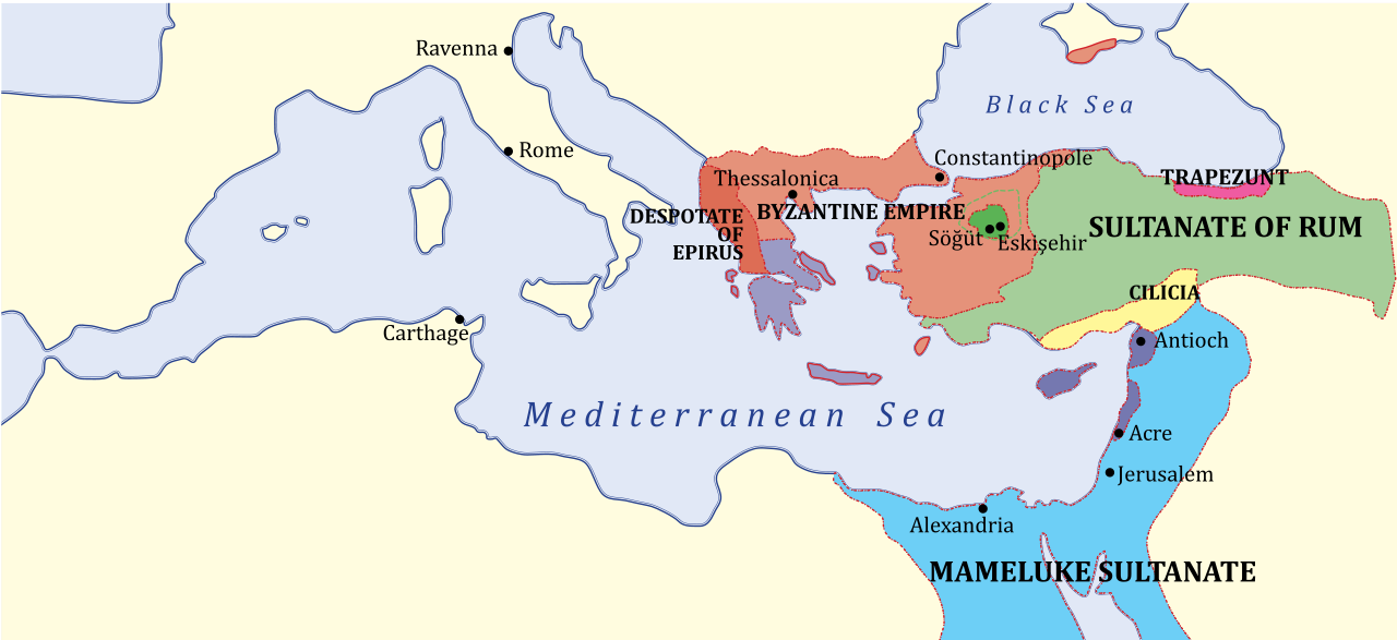
English: Map of Eastern Mediterranean region — with Near East and southeastern Balkans, c. 1263.
|
| Data | (UTC) |
| Font | |
| Autor |
|
| Altres versions |
[]
|


| Això és una imatge retocada, cosa que vol dir que ha estat alterada digitalment de la seva versió original. Modificacions: SVG version. L'original es pot veure a: 1263 Mediterranean Sea.PNG:
|
en:Category:Maps of the Byzantine Empire
Llicència
Jo, el titular dels drets d'autor d'aquest treball, el public sota la següent llicència:
| |
Aquesta imatge ha estat, o ho és d'ara endavant, alliberada al domini públic pel seu autor, Example del projecte [[::Main Page| Wikimedia Commons]]. Això s'aplica a escala mundial. En cas que no sigui legalment possible: |
Registre original de càrregues
This image is a derivative work of the following images:
- File:1263_Mediterranean_Sea.PNG licensed with PD-user-w
- 2009-08-31T12:53:31Z Shizhao 801x370 (141734 Bytes) {{Information |Description={{en|Middle East c. 1263. KEY: *Dark Green: Ottoman domain by 1300's, dotted line indicates conquests up to 1326 *Purple: Byzantine Empire (successor of Nicaean Empire) *Light Green: Turk lands, nom
Uploaded with derivativeFX
Historial del fitxer
Cliqueu una data/hora per veure el fitxer tal com era aleshores.
| Data/hora | Miniatura | Dimensions | Usuari/a | Comentari | |
|---|---|---|---|---|---|
| actual | 19:08, 10 des 2011 | | 925 × 424 (704 Ko) | Hoodinski | == {{int:filedesc}} == {{Information |Description={{en|Middle East c. 1263. KEY: *Dark Green: Ottoman domain by 1300's, dotted line indicates conquests up to 1326 *Purple: Byzantine Empire (successor of Nicaean Empire) *Light Green: Turk lands, nominal va |
Ús del fitxer
No hi ha pàgines que utilitzin aquest fitxer.
Ús global del fitxer
Utilització d'aquest fitxer en altres wikis:
- Utilització a azb.wikipedia.org
- Utilització a az.wikipedia.org
- Utilització a ba.wikipedia.org
- Utilització a bn.wikipedia.org
- Utilització a cs.wikipedia.org
- Utilització a el.wikipedia.org
- Utilització a en.wikipedia.org
- Utilització a et.wikipedia.org
- Utilització a id.wikipedia.org
- Utilització a it.wikipedia.org
- Utilització a ko.wikipedia.org
- Utilització a mk.wikipedia.org
- Utilització a ms.wikipedia.org
- Utilització a pl.wikipedia.org
- Utilització a rm.wikipedia.org
- Utilització a ru.wikipedia.org
- Utilització a sk.wikipedia.org
- Utilització a sl.wikipedia.org
- Utilització a sr.wikipedia.org
- Utilització a tr.wikipedia.org
- Utilització a uk.wikipedia.org
- Utilització a vi.wikipedia.org
- Utilització a zh.wikipedia.org