Fitxer:17-08-islcanus-RalfR-DSC 3282.jpg

Fitxer original(5.905 × 3.937 píxels, mida del fitxer: 12,23 Mo, tipus MIME: image/jpeg)

Descripció a Commons

Resum

Descripció
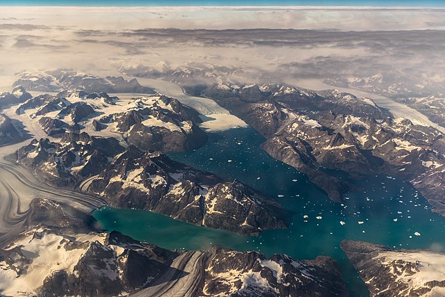
Deutsch: Westküste von Grönland; Blick Richtung NNW aus 10 km Höhe und 40 km Entfernung; Flugzeug war ca 25 km östlich des Tingmiarmit
Data
Font Treball propi
Autor

© Ralf Roletschek

Ralf Roletschek  (1963–)  wikidata:Q15080600
 
Ralf Roletschek
Descripció enginyer civil i fotògraf alemany
Data de naixement 1963 Edita-ho a Wikidata
Lloc de naixement Eberswalde
Període de treball from 1979
date QS:P,+1979-00-00T00:00:00Z/7,P580,+1979-00-00T00:00:00Z/9
Lloc de treball
Barcelona, Wien, Eberswalde
Control d'autoritats
creator QS:P170,Q15080600
Permís
(Com reutilitzar aquest fitxer)

Dieses Foto ist von Ralf Roletschek

Achtung: Dieses Bild ist nicht gemeinfrei. Es ist zwar frei benutzbar, aber gesetzlich geschützt.

This photo was created by Ralf Roletschek

Note: this image is not in the Public Domain. It is free to use but protected by law.

Entweder wird der Hinweis entsprechend den Lizenzbedingungen angegeben oder wie folgt:

Ralf Roletschek / Roletschek.at mit Link zu meiner Homepage

in unmittelbarer Nähe beim Bild oder an einer Stelle in ihrer Publikation, wo dies üblich ist. Dabei muß der Zusammenhang zwischen Bild und Urhebernennung gewahrt bleiben. In jedem Fall sind Urheber und Lizenz zu nennen.

Either the notice is given in accordance with the license conditions or as follows::

Ralf Roletschek / Roletschek.at with link to my homepage

near to the photo or at a location that is common in your publication but preserving the association between image and credit. In any event, copyright and license are to be mentioned.

Bitte lesen Sie den vollen Lizenztext gründlich, bevor Sie das Bild nutzen! Wenn Sie Fragen zu den Lizenzvereinbarungen haben oder weniger restriktive kommerzielle Lizenzen wünschen, kontaktieren Sie mich per Mail: ralf@roletschek.at Die Verwendung eines meiner Fotos in Facebook werde ich als Urheberrechtsverletzung verfolgen lassen.

Please review the full license requirements carefully before using this image. If you would like to clarify the terms of the license or negotiate less restrictive commercial licensing outside of the bounds of Licenses, please contact me by email: ralf@roletschek.at

Please do not upload a modified image here without consultation with the author.
The author would like to make possible minor modifications only at his own source. (The source is usually a RAW file. Processing of the JPEG file means a loss of quality.) This ensures that the changes and the quality are preserved.
If you think that any changes should be required, please contact the author.
Otherwise you can upload a new image with a new name. Please use one of the templates Derivative or Extracted. Please enter your name too, if you upload a derivative or a detail, because you're in charge of the changes.
Please do not rename this file. The name is part of the attribution. In the case of misstatements, the author is pleased to provide information.

Llicència

GNU head S'autoritza la còpia, la distribució i la modificació d'aquest document sota els termes de la llicència de documentació lliure GNU versió 1.2, publicada per la Free Software Foundation; sense seccions invariants, ni textos de portada, ni textos de contraportada. S'inclou una còpia d'aquesta llicència en la secció titulada GNU Free Documentation License. 1.2 només
Posició de la càmera62° 51′ 00″ N, 41° 58′ 00″ O Kartographer map based on OpenStreetMap.Aquesta i altres imatges properes a: OpenStreetMapinfo
Posició de l'objecte63° 08′ 00″ N, 42° 06′ 00″ O  Heading=345° Kartographer map based on OpenStreetMap.Aquesta i altres imatges properes a: OpenStreetMapinfo

(etwa Gletscherzunge in Bildmitte)

Aquest imatge ha estat examinada usant la guia per a les imatges de qualitat i és considerada com una imatge de qualitat.

العربية  جازايرية  беларуская  беларуская (тарашкевіца)  български  বাংলা  català  čeština  Cymraeg  Deutsch  Schweizer Hochdeutsch  Zazaki  Ελληνικά  English  Esperanto  español  eesti  euskara  فارسی  suomi  français  galego  עברית  हिन्दी  hrvatski  magyar  հայերեն  Bahasa Indonesia  italiano  日本語  Jawa  ქართული  한국어  kurdî  Lëtzebuergesch  lietuvių  македонски  മലയാളം  मराठी  Bahasa Melayu  Nederlands  Norfuk / Pitkern  polski  português  português do Brasil  rumantsch  română  русский  sicilianu  slovenčina  slovenščina  shqip  српски / srpski  svenska  தமிழ்  తెలుగు  ไทย  Tagalog  Türkçe  toki pona  українська  vèneto  Tiếng Việt  中文  中文(简体)  中文(繁體)  +/−

Llegendes

Afegeix una explicació d'una línia del que representa aquest fitxer

Elements representats en aquest fitxer

representa l'entitat

62°51'0.000"N, 41°58'0.001"W

63°7'59.999"N, 42°6'0.000"W

direcció des del punt de vista: 345 grau sexagesimal

12.827.316 byte

3.937 píxel

5.905 píxel

Historial del fitxer

Cliqueu una data/hora per veure el fitxer tal com era aleshores.

Data/horaMiniaturaDimensionsUsuari/aComentari
actual21:39, 19 ago 2017Miniatura per a la versió del 21:39, 19 ago 20175.905 × 3.937 (12,23 Mo)Ralf Roletschek

La pàgina següent utilitza aquest fitxer:

Ús global del fitxer

Utilització d'aquest fitxer en altres wikis:

Metadades