Fitxer:Abandoned farm and crop markings - geograph.org.uk - 55168.jpg
No hi ha cap versió amb una resolució més gran.
Abandoned_farm_and_crop_markings_-_geograph.org.uk_-_55168.jpg (640 × 427 píxels, mida del fitxer: 181 Ko, tipus MIME: image/jpeg)
| Aquest fitxer i la informació mostrada a continuació provenen del dipòsit multimèdia lliure Wikimedia Commons. |
Resum
| Descripció |
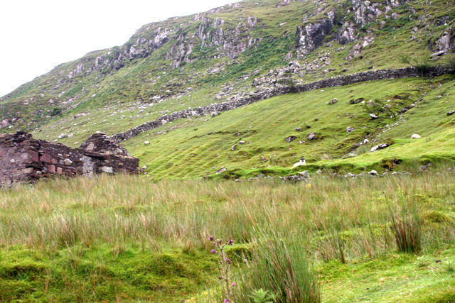
English: Abandoned farm and crop markings. On the steep sides of Killary Harbour, adjacent to the 'famine road' built as part of a poor relief scheme during the potato blight of 1845-49, there are a number of abandoned farms. In the field above the derelict building you can see the parallel banks created by earthing up a potato crop over a period of years. |
| Data | |
| Font | From geograph.org.uk |
| Autor | Kevin Danks |
| Reconeixement (required by the license) | Kevin Danks / Abandoned farm and crop markings / |
| Posició de la càmera | | Aquesta i altres imatges properes a: OpenStreetMap |
|---|
_&language=ca)
Llicència

|
Aquesta imatge prové de la col·lecció del projecte Geograph British Isles. Vegeu la pàgina d'aquesta fotografia al lloc web Geograph per a més informació del fotògraf. El titular dels drets d'autor d'aquesta imatge és Kevin Danks i autoritza utilitzar-la sota la llicència Reconeixement-CompartirIgual 2.0 de Creative Commons.
|
Aquest fitxer està publicat sota la llicència de Creative Commons Reconeixement i Compartir Igual 2.0 Genèrica.
Reconeixement: Kevin Danks
- Sou lliure de:
- compartir – copiar, distribuir i comunicar públicament l'obra
- adaptar – fer-ne obres derivades
- Amb les condicions següents:
- reconeixement – Heu de donar la informació adequada sobre l'autor, proporcionar un enllaç a la llicència i indicar si s'han realitzat canvis. Podeu fer-ho amb qualsevol mitjà raonable, però de cap manera no suggereixi que l'autor us dóna suport o aprova l'ús que en feu.
- compartir igual – Si modifiqueu, transformeu, o generareu amb el material, haureu de distribuir les vostres contribucions sota una llicència similar o una de compatible com l'original
Historial del fitxer
Cliqueu una data/hora per veure el fitxer tal com era aleshores.
| Data/hora | Miniatura | Dimensions | Usuari/a | Comentari | |
|---|---|---|---|---|---|
| actual | 14:43, 30 gen 2010 | | 640 × 427 (181 Ko) | GeographBot | == {{int:filedesc}} == {{Information |description={{en|1=Abandoned farm and crop markings. On the steep sides of Killary Harbour, adjacent to the 'famine road' built as part of a poor relief scheme during the potato blight of 1845-49, there are a number o |
Ús del fitxer
La pàgina següent utilitza aquest fitxer: