Fitxer:Agassiz.jpg
Mida d'aquesta previsualització: 785 × 600 píxels. Altres resolucions: 314 × 240 píxels | 629 × 480 píxels | 1.006 × 768 píxels | 1.280 × 978 píxels | 2.560 × 1.955 píxels | 2.832 × 2.163 píxels.
Fitxer original (2.832 × 2.163 píxels, mida del fitxer: 6,82 Mo, tipus MIME: image/jpeg)
| Aquest fitxer i la informació mostrada a continuació provenen del dipòsit multimèdia lliure Wikimedia Commons. |
Copied from the English Wikipedia. Original comment below:
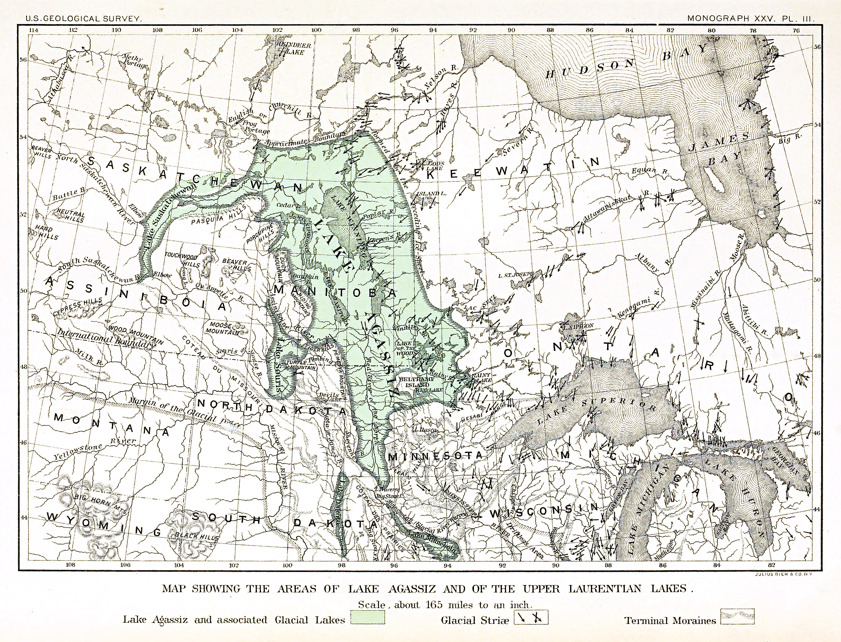
Map of the extent of glacial en:Lake Agassiz.
Bibliographical information: Upham, Warren. "The Glacial Lake Agassiz" archive copy at the Wayback Machine. Plate III. Monographs of the en:United States Geological Survey: Volume XXV. Washington Government Printing Office: Washington, 1895.
Aquesta imatge és de domini públic, ja que conté materials que originalment van venir del Servei Geològic dels Estats Units d'Amèrica, una agència del Departament de l'Interior dels Estats Units. Per a obtenir més informació, consulti la política oficial de drets de l'USGS.
|
Historial del fitxer
Cliqueu una data/hora per veure el fitxer tal com era aleshores.
| Data/hora | Miniatura | Dimensions | Usuari/a | Comentari | |
|---|---|---|---|---|---|
| actual | 01:17, 14 ago 2015 | | 2.832 × 2.163 (6,82 Mo) | Themadchopper | larger etc. |
| 02:00, 8 set 2005 |  | 938 × 713 (309 Ko) | L.m.k | Copied from the English Wikipedia. Original comment below: Map of the extent of glacial en:Lake Agassiz. Bibliographical information: Upham, Warren. [http://www.lib.ndsu.nodak.edu/govdocs/text/lakeagassiz/ "The Glacial Lake Agassiz"]. Plate III. M |
Ús del fitxer
La pàgina següent utilitza aquest fitxer:
Ús global del fitxer
Utilització d'aquest fitxer en altres wikis:
- Utilització a ar.wikipedia.org
- Utilització a be.wikipedia.org
- Utilització a bg.wikipedia.org
- Utilització a cs.wikipedia.org
- Utilització a de.wikipedia.org
- Utilització a en.wikipedia.org
- Utilització a eo.wikipedia.org
- Utilització a es.wikipedia.org
- Utilització a fi.wikipedia.org
- Utilització a fr.wikipedia.org
- Utilització a it.wikipedia.org
- Utilització a ja.wikipedia.org
- Utilització a ka.wikipedia.org
- Utilització a lv.wikipedia.org
- Utilització a ms.wikipedia.org
- Utilització a nl.wikipedia.org
- Utilització a nn.wikipedia.org
- Utilització a no.wikipedia.org
- Utilització a pl.wikipedia.org
- Utilització a pt.wikipedia.org
- Utilització a ru.wikipedia.org
- Utilització a sh.wikipedia.org
- Utilització a simple.wikipedia.org
- Utilització a sk.wikipedia.org
- Utilització a sl.wikipedia.org
- Utilització a sq.wikipedia.org
- Utilització a tr.wikipedia.org
- Utilització a uk.wikipedia.org
- Utilització a vi.wikipedia.org
- Utilització a www.wikidata.org
- Utilització a zh.wikipedia.org