Fitxer:Ain al-Assad air base, 8 jan 2020.png

Mida d'aquesta previsualització: 800 × 453 píxels. Altres resolucions: 320 × 181 píxels | 640 × 362 píxels | 1.024 × 580 píxels | 1.280 × 724 píxels | 2.000 × 1.132 píxels.
Fitxer original (2.000 × 1.132 píxels, mida del fitxer: 4,5 Mo, tipus MIME: image/png)
| Aquest fitxer i la informació mostrada a continuació provenen del dipòsit multimèdia lliure Wikimedia Commons. |
Resum
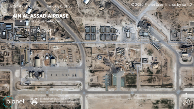
| Descripció | Satellite image, showing the damage to at least five structures at Ain al-Assad air base in Iraq in a series of precision missile strikes launched by Iran |
| Data | |
| Font |
First upload: Brumfiel, Geoff; Welna, David (8 January 2020). Satellite Photos Reveal Extent Of Damage From Iranian Strike On Air Base In Iraq. NPR. Current upload: Garger, Kenneth (8 January 2020). Before-and-after satellite images show damage to Iraqi base hit by Iran. New York Post. |
| Autor | Planet Labs, Inc. / Middlebury Institute of International Studies at Monterey |
| Permís (Com reutilitzar aquest fitxer) |
There is a copyright notice in the upper right of this image. "© 2020 Planet Labs, Inc. cc-by-sa 4.0" |
Llicència
This file is licensed under the Creative Commons Attribution-Share Alike 4.0 International license.
Reconeixement: Planet Labs, Inc.
- Sou lliure de:
- compartir – copiar, distribuir i comunicar públicament l'obra
- adaptar – fer-ne obres derivades
- Amb les condicions següents:
- reconeixement – Heu de donar la informació adequada sobre l'autor, proporcionar un enllaç a la llicència i indicar si s'han realitzat canvis. Podeu fer-ho amb qualsevol mitjà raonable, però de cap manera no suggereixi que l'autor us dóna suport o aprova l'ús que en feu.
- compartir igual – Si modifiqueu, transformeu, o generareu amb el material, haureu de distribuir les vostres contribucions sota una llicència similar o una de compatible com l'original
Historial del fitxer
Cliqueu una data/hora per veure el fitxer tal com era aleshores.
| Data/hora | Miniatura | Dimensions | Usuari/a | Comentari | |
|---|---|---|---|---|---|
| actual | 08:14, 9 gen 2020 | | 2.000 × 1.132 (4,5 Mo) | EnchanterTim | Higher resolution from: https://nypost.com/2020/01/08/before-and-after-satellite-images-show-damage-to-iraqi-base-hit-by-iran/ |
| 21:52, 8 gen 2020 |  | 800 × 449 (805 Ko) | Cold Season | {{Information |Description= Satellite image, showing the damage to at least five hangars and buildings at Ain al-Assad air base in Iraq in a series of precision missile strikes launched by Iran |Source= [https://www.npr.org/2020/01/08/794517031/satellite-photos-reveal-extent-of-damage-at-al-assad-air-base?t=1578512699906 Satellite Photos Reveal Extent Of Damage From Iranian Strike On Air Base In Iraq]. NPR. |Date= 8 January 2020 |Author= Planet Labs Inc./Middlebury Institute |Permission= |ot... |
Ús del fitxer
La pàgina següent utilitza aquest fitxer:
Ús global del fitxer
Utilització d'aquest fitxer en altres wikis:
- Utilització a ar.wikipedia.org
- Utilització a be.wikipedia.org
- Utilització a ckb.wikipedia.org
- Utilització a en.wikipedia.org
- Utilització a es.wikipedia.org
- Utilització a fa.wikipedia.org
- Utilització a fi.wikipedia.org
- Utilització a fr.wikipedia.org
- Utilització a he.wikipedia.org
- Utilització a id.wikipedia.org
- Utilització a ja.wikipedia.org
- Utilització a ka.wikipedia.org
- Utilització a ko.wikipedia.org
- Utilització a nl.wikipedia.org
- Utilització a nl.wikinews.org
- Utilització a pnb.wikipedia.org
- Utilització a pt.wikipedia.org
- Utilització a ru.wikipedia.org
- Utilització a ru.wikinews.org
- Utilització a so.wikipedia.org
- Utilització a uk.wikipedia.org
- Utilització a ur.wikipedia.org
- Utilització a vi.wikipedia.org
- Utilització a www.wikidata.org
- Utilització a zh.wikipedia.org