Fitxer:Bodies on the battlefield at antietam.jpg

Mida d'aquesta previsualització: 800 × 560 píxels. Altres resolucions: 320 × 224 píxels | 640 × 448 píxels | 1.024 × 717 píxels | 1.280 × 897 píxels | 2.560 × 1.793 píxels | 6.202 × 4.344 píxels.
Fitxer original (6.202 × 4.344 píxels, mida del fitxer: 5,89 Mo, tipus MIME: image/jpeg)
| Aquest fitxer i la informació mostrada a continuació provenen del dipòsit multimèdia lliure Wikimedia Commons. |
Resum
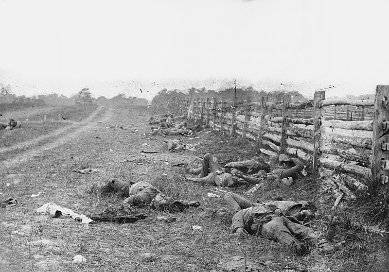
| Alexander Gardner: Bodies on the battlefield at Antietam
|
||||||||||||||||||||||||||||
|---|---|---|---|---|---|---|---|---|---|---|---|---|---|---|---|---|---|---|---|---|---|---|---|---|---|---|---|---|
| Fotògraf |
|
 | ||||||||||||||||||||||||||
| Títol |
The Dead of Antietam |
|||||||||||||||||||||||||||
| Object type |
fotografia |
|||||||||||||||||||||||||||
| Gènere |
fotoperiodisme |
|||||||||||||||||||||||||||
| Descripció |
Photograph of the field at Antietam, American Civil War. Confederate dead by a fence at the Hagerstown Turnpike, looking north; the Turnpike is to the right of the fence, the dirt lane on the left leads to the farm of David Miller. |
|||||||||||||||||||||||||||
| Data | Taken in setembre de 1862 | |||||||||||||||||||||||||||
| Referències |
100 Photographs: The Most Influential Images of All Time |
|||||||||||||||||||||||||||
| Font |
|
|||||||||||||||||||||||||||
| Permís (Com reutilitzar aquest fitxer) |
Public domain | |||||||||||||||||||||||||||


| Posició de la càmera | | Aquesta i altres imatges properes a: OpenStreetMap |
|---|
Llicència
|
Aquest material està en domini públic als Estats Units i als altres països on el dret d'autor s'estén per 100 anys (o menys) després de la mort de l'autor. Aquesta obra es troba en el domini públic als Estats Units d'Amèrica per haver estat publicada abans de l'1 de gener de 1929. | |
| Aquest fitxer està identificat com a lliure de restriccions conegudes sota la llei de drets d'autor, inclosos els drets veïns. | |
Historial del fitxer
Cliqueu una data/hora per veure el fitxer tal com era aleshores.
| Data/hora | Miniatura | Dimensions | Usuari/a | Comentari | |
|---|---|---|---|---|---|
| actual | 00:29, 13 ago 2013 | | 6.202 × 4.344 (5,89 Mo) | Ras67 | high resolution |
| 00:36, 14 maig 2011 |  | 838 × 587 (104 Ko) | Cropbot | upload cropped version, operated by User:Beao. Summary: cropped away burned edges | |
| 17:47, 11 ago 2005 |  | 971 × 728 (135 Ko) | Shauni | Photograph of the field at Antietam, American Civil War. From the Library of Congress' American Memory collection ORIGINAL LOCATION: http://memory.loc.gov/ndlpcoop/nhnycw/ad/ad18/ad18045v.jpg {{PD}} Category:American Civil War |
Ús del fitxer
Les 2 pàgines següents utilitzen aquest fitxer:
Ús global del fitxer
Utilització d'aquest fitxer en altres wikis:
- Utilització a ar.wikipedia.org
- Utilització a ast.wikipedia.org
- Utilització a azb.wikipedia.org
- Utilització a az.wikipedia.org
- Utilització a co.wikipedia.org
- Utilització a cs.wikipedia.org
- Utilització a da.wikipedia.org
- Utilització a de.wikipedia.org
- Utilització a en.wikipedia.org
- Battle of Antietam
- Military history of the United States
- Timeline of United States history (1860–1899)
- Alexander Gardner (photographer)
- History of Maryland
- War photography
- Maryland in the American Civil War
- List of photographs considered the most important
- 2nd Louisiana Infantry Regiment (Confederate)
- User:Howardcorn33/sandbox/List of photographs considered the most important
- User:Snowmanonahoe/List of photographs considered the most important
- Utilització a en.wikiquote.org
- Utilització a eo.wikipedia.org
- Utilització a es.wikipedia.org
- Utilització a fa.wikipedia.org
- Utilització a fy.wikipedia.org
- Utilització a he.wikipedia.org
- Utilització a hy.wikipedia.org
- Utilització a id.wikipedia.org
- Utilització a incubator.wikimedia.org
- Utilització a it.wikipedia.org
- Utilització a ja.wikipedia.org
Vegeu més usos globals d'aquest fitxer.