Fitxer:Brabant1477.png
Brabant1477.png (409 × 362 píxels, mida del fitxer: 331 Ko, tipus MIME: image/png)
| Aquest fitxer i la informació mostrada a continuació provenen del dipòsit multimèdia lliure Wikimedia Commons. |
Resum
| Descripció | |
| Font | William R. Shepherd |
| Autor | William R. Shepherd |
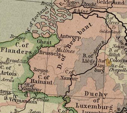
English: This map come from the map collection of University of Texas, specifically from: Central Europe in 1477, from Historical Atlas by William R. Shepherd, 1926.. It is in the public domain (http://www.lib.utexas.edu/maps/faq.html#3.html).
Français : Cette carte est issue issu de la collection de cartes de l'université du Texas et plus précisément de celle-ci : Central Europe in 1477, from Historical Atlas by William R. Shepherd, 1926.. Elle se trouve dans dans le domaine public (http://www.lib.utexas.edu/maps/faq.html#3.html).
Nederlands: Deze afbeelding is afkomstig uit de kaartencollectie van de University of Texas. Deze kaarten bevinden zich in het publiek domein (http://www.lib.utexas.edu/maps/faq.html#3.html).
|
|
Aquest material està en domini públic als Estats Units i als altres països on el dret d'autor s'estén per 70 anys (o menys) després de la mort de l'autor.
| |
| Aquest fitxer està identificat com a lliure de restriccions conegudes sota la llei de drets d'autor, inclosos els drets veïns. | |
Historial del fitxer
Cliqueu una data/hora per veure el fitxer tal com era aleshores.
| Data/hora | Miniatura | Dimensions | Usuari/a | Comentari | |
|---|---|---|---|---|---|
| actual | 10:56, 27 març 2006 | | 409 × 362 (331 Ko) | Odejea | == Description == 25px : Carte du duché de Brabant, en 1477 25px : Map of duchy of Brabant, in 1477 * uploadé sur Wikipédia NL par [[:nl:Gebruike |
Ús del fitxer
Les 2 pàgines següents utilitzen aquest fitxer:
Ús global del fitxer
Utilització d'aquest fitxer en altres wikis:
- Utilització a ar.wikipedia.org
- Utilització a arz.wikipedia.org
- Utilització a ast.wikipedia.org
- Utilització a be.wikipedia.org
- Utilització a br.wikipedia.org
- Utilització a cs.wikipedia.org
- Utilització a da.wikipedia.org
- Utilització a en.wikipedia.org
- Utilització a eo.wikipedia.org
- Utilització a es.wikipedia.org
- Utilització a et.wikipedia.org
- Utilització a eu.wikipedia.org
- Utilització a fi.wikipedia.org
- Utilització a fr.wikipedia.org
- Utilització a gl.wikipedia.org
- Utilització a he.wikipedia.org
- Utilització a hu.wikipedia.org
- Utilització a id.wikipedia.org
- Utilització a ja.wikipedia.org
- Utilització a ka.wikipedia.org
- Utilització a ko.wikipedia.org
- Utilització a li.wiktionary.org
- Utilització a nl.wikipedia.org
- Utilització a nl.wiktionary.org
- Utilització a pt.wikipedia.org
- Utilització a ru.wikipedia.org
- Utilització a sl.wikipedia.org
- Utilització a sv.wikipedia.org
- Utilització a th.wikipedia.org
- Utilització a tr.wikipedia.org
- Utilització a www.wikidata.org