Fitxer:Central Asian trade routes.jpg
Fitxer original (954 × 674 píxels, mida del fitxer: 206 Ko, tipus MIME: image/jpeg)
| Aquest fitxer i la informació mostrada a continuació provenen del dipòsit multimèdia lliure Wikimedia Commons. |
Resum
| Descripció |
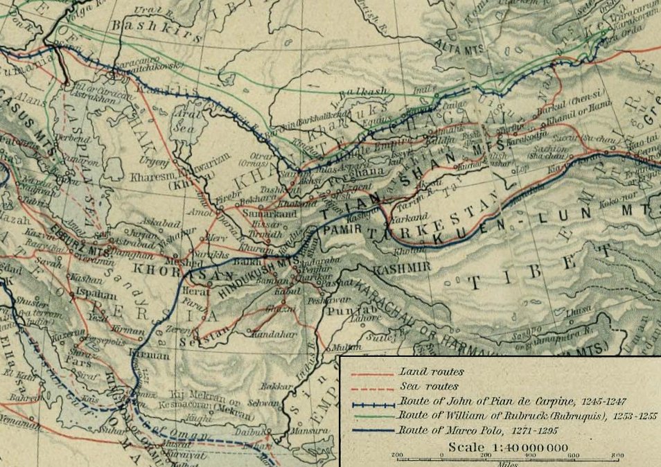
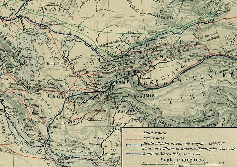
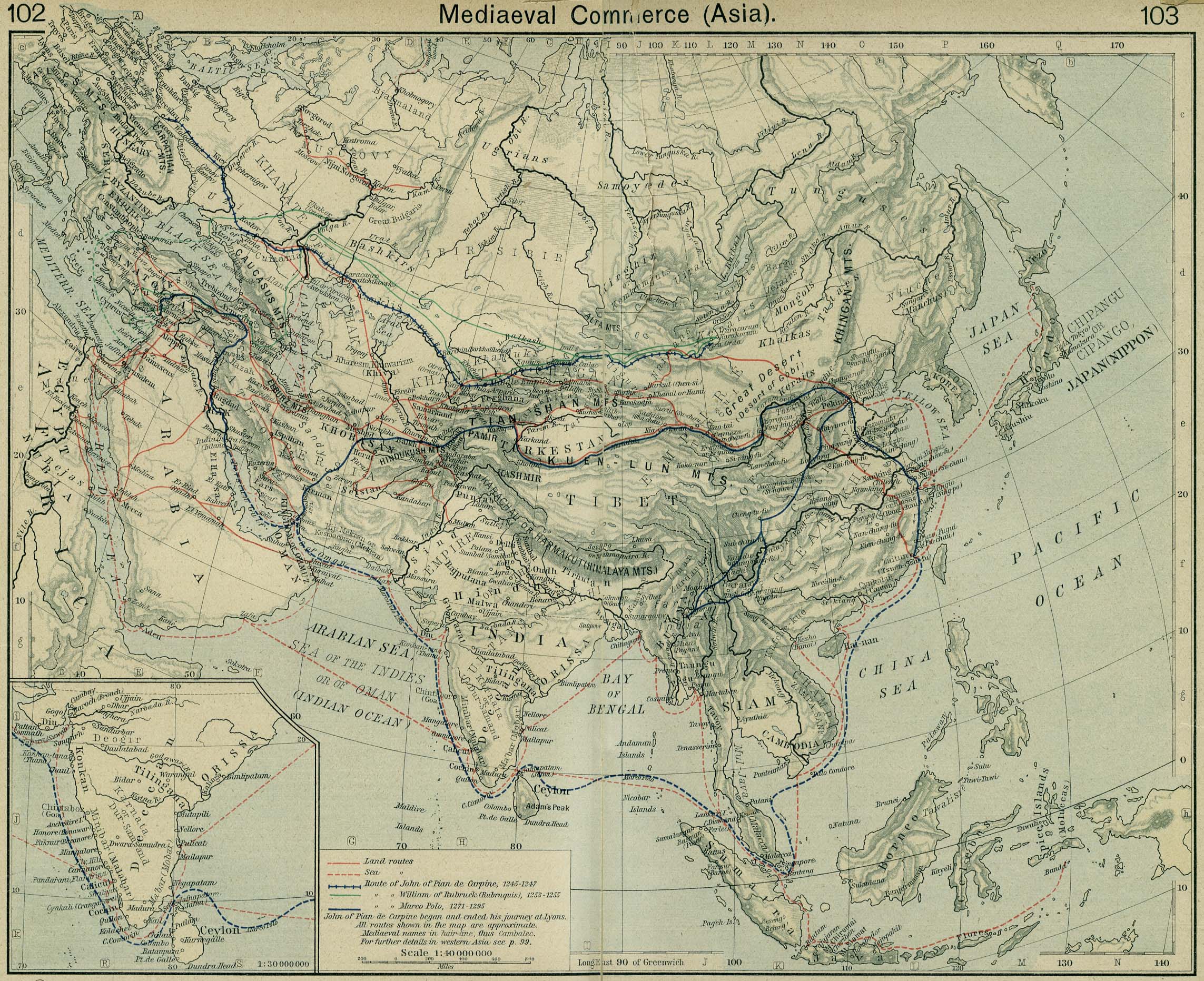
English: Mediaeval trade routes in central Asia. Modified map based on Sheherd Mediaeval Commerce (1923/first edition 1911)
Čeština: Středověké obchodní cesty ve střední Asii. Upravená mapa na základě "Historického atlasu" W. R. Shepherda, 1923 |
||||||||||||||||||||||
| Font |
From the "Historical Atlas" by William R. Shepherd, New York, Henry Holt and Company, 1923 (2nd edition) |
||||||||||||||||||||||
| Autor |
|
||||||||||||||||||||||
Llicència
|
Aquest material està en domini públic als Estats Units i als altres països on el dret d'autor s'estén per 70 anys (o menys) després de la mort de l'autor.
| |
| Aquest fitxer està identificat com a lliure de restriccions conegudes sota la llei de drets d'autor, inclosos els drets veïns. | |
| Anotacions | Aquesta imatge té anotacions: Vegeu-les a Commons |
Historial del fitxer
Cliqueu una data/hora per veure el fitxer tal com era aleshores.
| Data/hora | Miniatura | Dimensions | Usuari/a | Comentari | |
|---|---|---|---|---|---|
| actual | 01:25, 28 maig 2006 | | 954 × 674 (206 Ko) | Ignacio Icke | Modified version of a 1926 public domain map from [http://www.lib.utexas.edu/maps/historical/shepherd/asia_mediaeval_commerce.jpg]. from en:Image:Central Asian trade routes.jpg Category:Central Asia Category:Trade Routes |
Ús del fitxer
Les 3 pàgines següents utilitzen aquest fitxer:
Ús global del fitxer
Utilització d'aquest fitxer en altres wikis:
- Utilització a als.wikipedia.org
- Utilització a ar.wikipedia.org
- Utilització a arz.wikipedia.org
- Utilització a avk.wikipedia.org
- Utilització a az.wikipedia.org
- Utilització a ba.wikipedia.org
- Utilització a be.wikipedia.org
- Utilització a bg.wikipedia.org
- Utilització a cs.wikipedia.org
- Utilització a da.wikipedia.org
- Utilització a de.wikipedia.org
- Utilització a en.wikipedia.org
- Utilització a en.wikisource.org
- Utilització a eo.wikipedia.org
- Utilització a es.wikipedia.org
- Utilització a es.wikisource.org
- Utilització a eu.wikipedia.org
- Utilització a fa.wikipedia.org
- Utilització a fi.wikipedia.org
- Utilització a fr.wikipedia.org
- Utilització a id.wikipedia.org
- Utilització a it.wikipedia.org
- Utilització a it.wikiquote.org
- Utilització a it.wikisource.org
- Utilització a ja.wikipedia.org
- Utilització a ka.wikipedia.org
- Utilització a kk.wikipedia.org
- Utilització a la.wikipedia.org
- Utilització a la.wikisource.org
- Utilització a mn.wikipedia.org
- Utilització a nl.wikipedia.org
- Utilització a no.wikipedia.org
Vegeu més usos globals d'aquest fitxer.