Fitxer:Chalkidiki - DEM Map Topo - DE.png
Mida d'aquesta previsualització: 800 × 500 píxels. Altres resolucions: 320 × 200 píxels | 640 × 400 píxels | 1.024 × 640 píxels | 1.280 × 801 píxels | 2.072 × 1.296 píxels.
Fitxer original (2.072 × 1.296 píxels, mida del fitxer: 1,42 Mo, tipus MIME: image/png)
| Aquest fitxer i la informació mostrada a continuació provenen del dipòsit multimèdia lliure Wikimedia Commons. |
Resum
| Descripció |
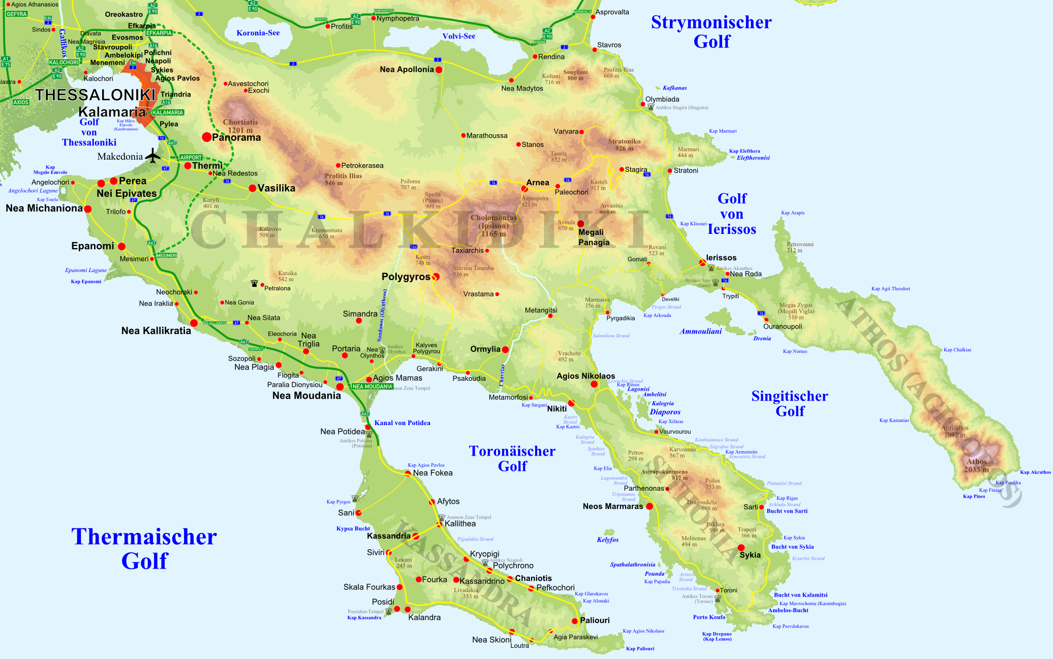
Deutsch: Topographische Karte der Halbinsel w:de:Chalkidiki in w:de:Griechenland ergänzt um Straßen, Ortschaften und Bezeichnungen. English: Topographic Map of w:Chalkidiki peninsula, w:Greece, supplemented with roads, settlements, topographic designations |
| Data | |
| Font | Treball propi |
| Autor | Christaras A |
| Altres versions |
 |
Llicència
Jo, el titular dels drets d'autor d'aquest treball, el public sota les següents llicències:
Aquest fitxer està subjecte a la llicència de Creative Commons Reconeixement i Compartir Igual 3.0 No adaptada.
- Sou lliure de:
- compartir – copiar, distribuir i comunicar públicament l'obra
- adaptar – fer-ne obres derivades
- Amb les condicions següents:
- reconeixement – Heu de donar la informació adequada sobre l'autor, proporcionar un enllaç a la llicència i indicar si s'han realitzat canvis. Podeu fer-ho amb qualsevol mitjà raonable, però de cap manera no suggereixi que l'autor us dóna suport o aprova l'ús que en feu.
- compartir igual – Si modifiqueu, transformeu, o generareu amb el material, haureu de distribuir les vostres contribucions sota una llicència similar o una de compatible com l'original

|
S'autoritza la còpia, la distribució i la modificació d'aquest document sota els termes de la llicència de documentació lliure GNU versió 1.2 o qualsevol altra versió posterior que publiqui la Free Software Foundation; sense seccions invariants, ni textos de portada, ni textos de contraportada. S'inclou una còpia d'aquesta llicència en la secció titulada GNU Free Documentation License. |
Podeu seleccionar la llicència que vulgueu.
Historial del fitxer
Cliqueu una data/hora per veure el fitxer tal com era aleshores.
| Data/hora | Miniatura | Dimensions | Usuari/a | Comentari | |
|---|---|---|---|---|---|
| actual | 16:44, 10 maig 2008 | | 2.072 × 1.296 (1,42 Mo) | Christaras A | == Summary == {{Information |Description={{de|Topographische Karte der Halbinsel w:de:Chalkidiki in w:de:Griechenland ergänzt um Straßen, Ortschaften und Bezeichnungen.}}<br/>{{en|Topographic Map of w:Chalkidiki peninsula, w:Greece, supp |
Ús del fitxer
La pàgina següent utilitza aquest fitxer:
Ús global del fitxer
Utilització d'aquest fitxer en altres wikis:
- Utilització a az.wikipedia.org
- Utilització a be.wikipedia.org
- Utilització a bg.wikipedia.org
- Utilització a de.wikipedia.org
- Utilització a el.wikipedia.org
- Utilització a es.wikipedia.org
- Utilització a et.wikipedia.org
- Utilització a fi.wikipedia.org
- Utilització a fr.wikipedia.org
- Utilització a he.wikipedia.org
- Utilització a hu.wikipedia.org
- Utilització a it.wikipedia.org
- Utilització a ja.wikipedia.org
- Utilització a mk.wikipedia.org
- Utilització a pl.wiktionary.org
- Utilització a ru.wikipedia.org
- Utilització a uk.wikipedia.org
- Utilització a www.wikidata.org