Fitxer:Chaparrastique.jpg
No hi ha cap versió amb una resolució més gran.
Chaparrastique.jpg (640 × 432 píxels, mida del fitxer: 77 Ko, tipus MIME: image/jpeg)
| Aquest fitxer i la informació mostrada a continuació provenen del dipòsit multimèdia lliure Wikimedia Commons. |
| Descripció |
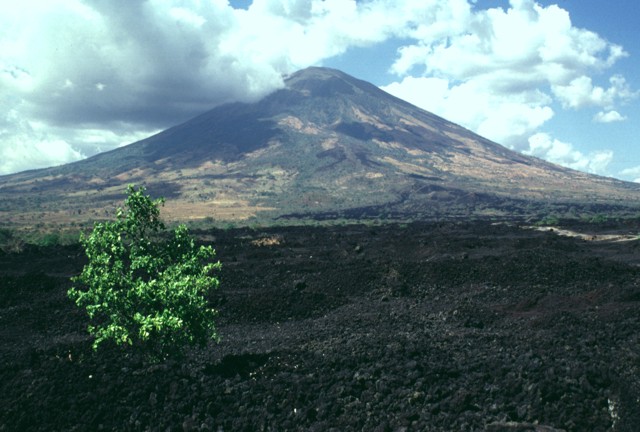
English: This sparsely vegetated basaltic lava flow was erupted from a fissure vent on the lower SE flank of San Miguel in 1819. The flow covers a broad 2.5-km-wide, 5-km-long area on the low-angle slopes below the volcano and reaches down to an elevation of less than 40 m above sea level. The principal coastal highway of El Salvador traverses the flow below the point of this photo, and the national railway crosses the flow closer to the vent. |
|||
| Data | ||||
| Font | http://www.volcano.si.edu/world/volcano.cfm?vnum=1403-10=&volpage=photos&photo=076042 | |||
| Autor | Lee Siebert (Smithsonian Institution) | |||
| Permís (Com reutilitzar aquest fitxer) |
|
Historial del fitxer
Cliqueu una data/hora per veure el fitxer tal com era aleshores.
| Data/hora | Miniatura | Dimensions | Usuari/a | Comentari | |
|---|---|---|---|---|---|
| actual | 23:37, 23 jul 2010 | | 640 × 432 (77 Ko) | Michael Metzger | {{Information |Description={{en|1=This sparsely vegetated basaltic lava flow was erupted from a fissure vent on the lower SE flank of San Miguel in 1819. The flow covers a broad 2.5-km-wide, 5-km-long area on the low-angle slopes below the volcano and rea |
Ús del fitxer
La pàgina següent utilitza aquest fitxer:
Ús global del fitxer
Utilització d'aquest fitxer en altres wikis:
- Utilització a az.wikipedia.org
- Utilització a be.wikipedia.org
- Utilització a de.wikipedia.org
- Utilització a fa.wikipedia.org
- Utilització a fr.wikipedia.org
- Utilització a hy.wikipedia.org
- Utilització a ru.wikipedia.org
- Utilització a simple.wikipedia.org
- Utilització a uk.wikipedia.org