Fitxer:Desceliers 1550 map - Australia detail.jpg

Fitxer original(2.711 × 2.589 píxels, mida del fitxer: 1,1 Mo, tipus MIME: image/jpeg)

Descripció a Commons
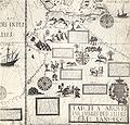
Descripció This is a detail from a 1550 world map by Pierre Desceliers, from the location where Australia would be, and purportedly showing Australian features. It is one of the Dieppe maps, which are commonly put forward as evidence for the theory that the Portuguese discovered Australia in the 16th century.
Data
Font This is a cropped and colour-balanced scan of an 1898 facsimile of this detail, taken from the British Museum's copy of the original map. Access to it is available on the National Library of Australia's website, at http://nla.gov.au/nla.map-rm2057-5. The graphical user interface provided does not support downloading the full image at full resolution, but the back end can be cajoled to do so by manually editing the CGI arguments in the URL.
Autor
Pierre Desceliers  (1487–1553)  wikidata:Q44053
 
Pierre Desceliers
Altres noms
Pierre Descalier
Descripció cartògraf i sacerdot catòlic francès
Data de naixement i defunció 1487 Edita-ho a Wikidata després de 1553
date QS:P,+1553-00-00T00:00:00Z/7,P1319,+1553-00-00T00:00:00Z/9
/ 1553 Edita-ho a Wikidata
Lloc de naixement Arques-la-Bataille
Període de treball 1537 fins 1553
date QS:P,+1550-00-00T00:00:00Z/7,P580,+1537-00-00T00:00:00Z/9,P582,+1553-00-00T00:00:00Z/9
 Edita-ho a Wikidata
Lloc de treball
Control d'autoritats
creator QS:P170,Q44053
Permís
(Com reutilitzar aquest fitxer)
Això és una mera fotografia d'una obra d'art bidimensional en domini públic. L'obra d'art original és en domini públic pel següent motiu:
Public domain

Aquest material està en domini públic als Estats Units i als altres països on el dret d'autor s'estén per 100 anys (o menys) després de la mort de l'autor.


Cal incloure una etiqueta de domini públic als Estats Units per indicar perquè aquesta obra és en domini públic als Estats Units.
La posició oficial de la Fundació Wikimedia és que «les reproduccions fidels d'obres d'art bidimensionals de domini públic són en domini públic».
Per tant, aquesta reproducció fotogràfica també es considera en domini públic als Estats Units. En altres jurisdiccions la reutilització d'aquest contingut pot estar restringida; vegeu Reuse of PD-Art photographs per a més informació.

Historial del fitxer

Cliqueu una data/hora per veure el fitxer tal com era aleshores.

Data/horaMiniaturaDimensionsUsuari/aComentari
actual03:03, 2 maig 2008Miniatura per a la versió del 03:03, 2 maig 20082.711 × 2.589 (1,1 Mo)Hesperiancolour balanced
14:34, 20 feb 2008Miniatura per a la versió del 14:34, 20 feb 20082.711 × 2.589 (920 Ko)Hesperianmuch higher resolution
14:18, 28 des 2007Miniatura per a la versió del 14:18, 28 des 2007732 × 696 (191 Ko)Hesperian{{Information |Description=This is a detail from a 1550 world map by Pierre Desceliers, from the location where Australia would be, and purportedly showing Australian features. It is one of the Dieppe maps, which are commonly put forward as eviden

La pàgina següent utilitza aquest fitxer:

Ús global del fitxer

Utilització d'aquest fitxer en altres wikis:

Metadades