Fitxer:Eratosthenes measure of Earth circumference.svg

Mida d'aquesta previsualització PNG del fitxer SVG: 512 × 341 píxels. Altres resolucions: 320 × 213 píxels | 640 × 426 píxels | 1.024 × 682 píxels | 1.280 × 853 píxels | 2.560 × 1.705 píxels.
Fitxer original (fitxer SVG, nominalment 512 × 341 píxels, mida del fitxer: 54 Ko)
| Aquest fitxer i la informació mostrada a continuació provenen del dipòsit multimèdia lliure Wikimedia Commons. |
Resum
| Descripció |
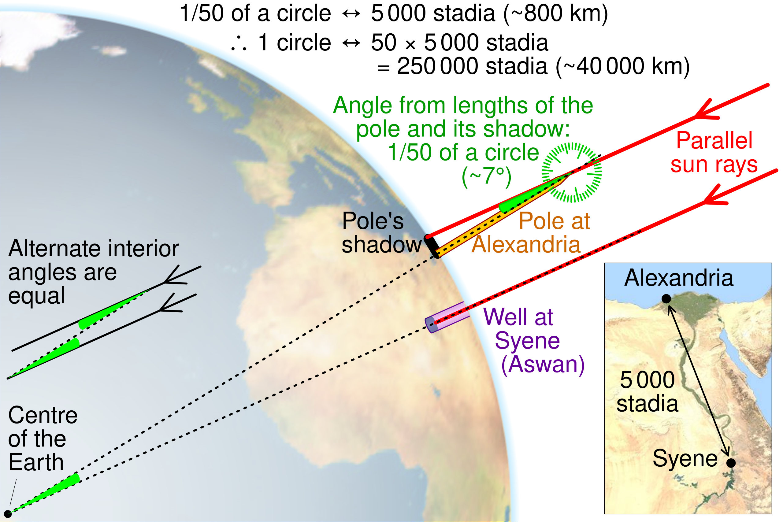
English: Illustration of the method Eratosthenes used to calculate the circumference of the Earth by CMG Lee. The map and globe are derived from http://commons.wikimedia.org/wiki/File:Egypt_sat.png and http://commons.wikimedia.org/wiki/File:Earth_orthographic_projection_Earthmap1000x500.jpg , respectively. |
||
| Data | |||
| Font |
|
||
| Autor | cmglee, David Monniaux, jimht at shaw dot ca |


Llicència
This file is licensed under the Creative Commons Attribution-Share Alike 4.0 International license.
- Sou lliure de:
- compartir – copiar, distribuir i comunicar públicament l'obra
- adaptar – fer-ne obres derivades
- Amb les condicions següents:
- reconeixement – Heu de donar la informació adequada sobre l'autor, proporcionar un enllaç a la llicència i indicar si s'han realitzat canvis. Podeu fer-ho amb qualsevol mitjà raonable, però de cap manera no suggereixi que l'autor us dóna suport o aprova l'ús que en feu.
- compartir igual – Si modifiqueu, transformeu, o generareu amb el material, haureu de distribuir les vostres contribucions sota una llicència similar o una de compatible com l'original
Historial del fitxer
Cliqueu una data/hora per veure el fitxer tal com era aleshores.
| Data/hora | Miniatura | Dimensions | Usuari/a | Comentari | |
|---|---|---|---|---|---|
| actual | 11:20, 15 feb 2023 | | 512 × 341 (54 Ko) | Getsnoopy | Fixed some formatting issues. |
| 12:11, 28 juny 2022 |  | 512 × 341 (54 Ko) | Andrei Stroe | File uploaded using svgtranslate tool (https://svgtranslate.toolforge.org/). Added translation for ro. | |
| 14:59, 9 oct 2019 |  | 512 × 341 (50 Ko) | Cmglee | Explain how shadow angle maps to angle around Earth centre. | |
| 21:30, 1 nov 2016 |  | 512 × 341 (49 Ko) | Cmglee | Use satellite photo instead of topo map, and add protractor. | |
| 02:34, 1 nov 2016 |  | 512 × 341 (48 Ko) | Cmglee | Outline shapes to work around thumbnail rendering bug losing gradient. | |
| 02:26, 1 nov 2016 |  | 512 × 341 (49 Ko) | Cmglee | User created page with UploadWizard |
Ús del fitxer
La pàgina següent utilitza aquest fitxer:
Ús global del fitxer
Utilització d'aquest fitxer en altres wikis:
- Utilització a bs.wikipedia.org
- Utilització a el.wikipedia.org
- Utilització a en.wikipedia.org
- Utilització a es.wikipedia.org
- Utilització a hi.wikipedia.org
- Utilització a hu.wikipedia.org
- Utilització a id.wikipedia.org
- Utilització a incubator.wikimedia.org
- Utilització a ja.wikipedia.org
- Utilització a ms.wikipedia.org
- Utilització a nl.wikipedia.org
- Utilització a pt.wikipedia.org
- Utilització a ro.wikipedia.org
- Utilització a sd.wikipedia.org
- Utilització a simple.wikipedia.org
- Utilització a sr.wikipedia.org
- Utilització a th.wikipedia.org
- Utilització a tr.wikipedia.org
- Utilització a uk.wikipedia.org
- Utilització a vi.wikipedia.org
- Utilització a zh.wikipedia.org