Fitxer:Franklingulfstream.jpg
Mida d'aquesta previsualització: 736 × 599 píxels. Altres resolucions: 295 × 240 píxels | 590 × 480 píxels | 943 × 768 píxels | 1.258 × 1.024 píxels | 2.516 × 2.048 píxels | 3.089 × 2.515 píxels.
Fitxer original (3.089 × 2.515 píxels, mida del fitxer: 1,2 Mo, tipus MIME: image/jpeg)
| Aquest fitxer i la informació mostrada a continuació provenen del dipòsit multimèdia lliure Wikimedia Commons. |
| Descripció |
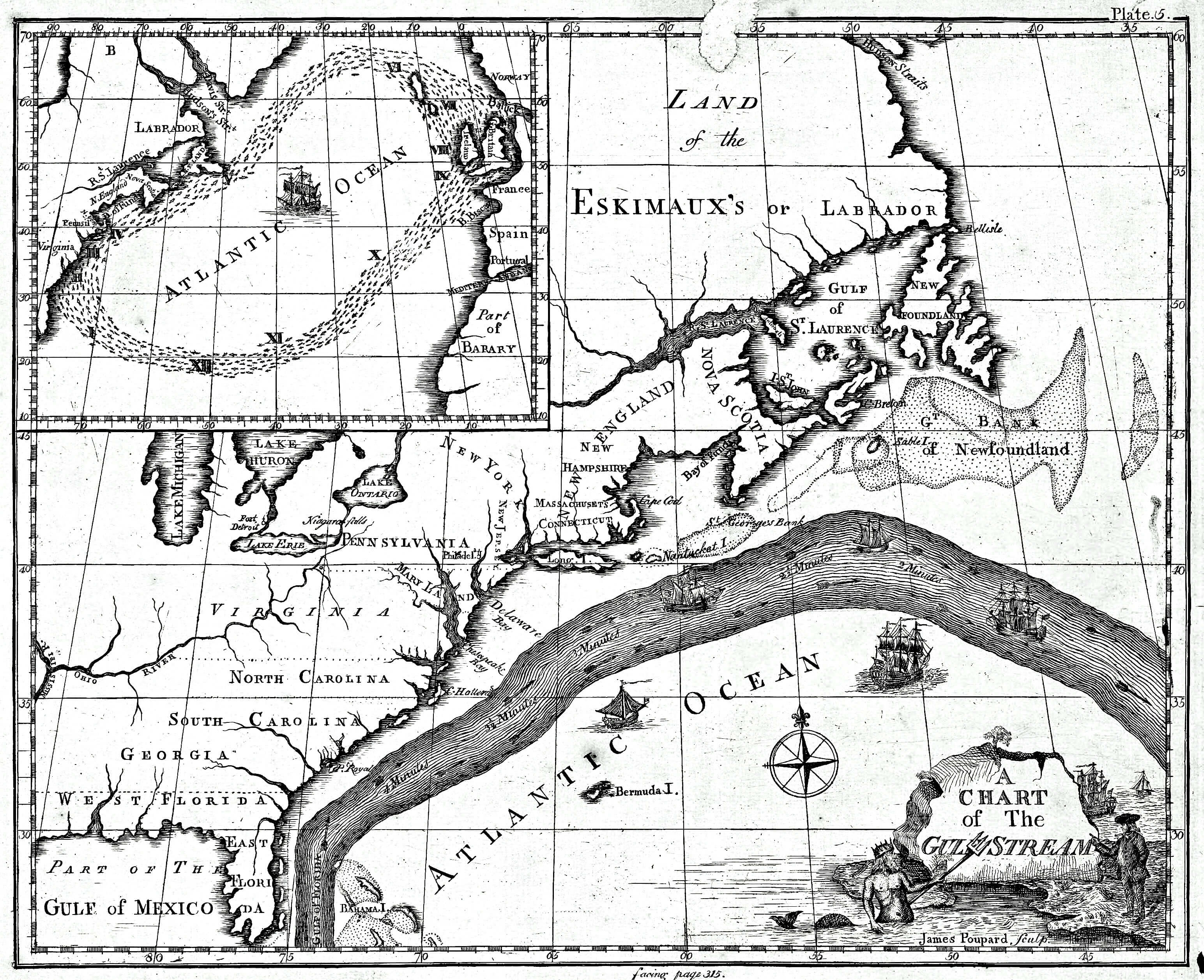
English: Earliest known map of the Gulf Stream |
| Data | |
| Font |
https://www.loc.gov/resource/g9112g.ct000136/ (2018-03-20)
|
| Autor | Library of Congress/Benjamin Franklin |
| Altres versions |
Cropped version uploaded in September 2016: |
Llicència
This image is in the public domain because it contains materials that originally came from the U.S. National Oceanic and Atmospheric Administration, taken or made as part of an employee's official duties.
|
Registre original de càrregues
La pàgina de descripció original era aquí. Els noms d'usuari a continuació es refereixen a en.wikipedia.
- 2008-09-21 12:47 Thegreatdr 540×433× (79994 bytes) {{Information |Description=Earliest known map of the Gulf Stream |Source=http://oceanexplorer.noaa.gov/library/readings/hires/gulf_stream_map.jpg |Date=2008-09-21 |Author=Library of Congress/Benjamin Franklin |Permission= |other_versions= }}
Historial del fitxer
Cliqueu una data/hora per veure el fitxer tal com era aleshores.
| Data/hora | Miniatura | Dimensions | Usuari/a | Comentari | |
|---|---|---|---|---|---|
| actual | 19:11, 25 abr 2021 | | 3.089 × 2.515 (1,2 Mo) | RCraig09 | Version 4: reduced file size at tinyjpg.com |
| 22:32, 20 març 2018 |  | 3.089 × 2.515 (2,45 Mo) | RCraig09 | Updated version from Library of Congress in response to note on talk page about watermark asserted to be present in earlier uploads. Source (2019-03-20): https://www.loc.gov/resource/g9112g.ct000136/ | |
| 22:39, 26 març 2012 |  | 5.868 × 4.761 (5,07 Mo) | ServiceAT | Replaced low resolution image by higher resolution scan of same original. | |
| 12:37, 7 jul 2009 |  | 540 × 433 (78 Ko) | Nk | {{Information |Description={{en|Earliest known map of the Gulf Stream}} |Source=Transferred from [http://en.wikipedia.org en.wikipedia]<br/> (Original text : ''http://oceanexplorer.noaa.gov/library/readings/hires/gulf_stream_map.jpg'') |Date={{Date|2008|0 |
Ús del fitxer
Les 2 pàgines següents utilitzen aquest fitxer:
Ús global del fitxer
Utilització d'aquest fitxer en altres wikis:
- Utilització a ast.wikipedia.org
- Utilització a ba.wikipedia.org
- Utilització a bg.wikipedia.org
- Utilització a bs.wikipedia.org
- Utilització a en.wikipedia.org
- Utilització a es.wikipedia.org
- Utilització a eu.wikipedia.org
- Utilització a fi.wikipedia.org
- Utilització a fr.wikipedia.org
- Utilització a ha.wikipedia.org
- Utilització a it.wikipedia.org
- Utilització a kn.wikipedia.org
- Utilització a mk.wikipedia.org
- Utilització a ms.wikipedia.org
- Utilització a nn.wikipedia.org
- Utilització a no.wikipedia.org
- Utilització a ru.wikipedia.org
- Utilització a si.wikipedia.org
- Utilització a sr.wikipedia.org
- Utilització a tr.wikipedia.org
- Utilització a uk.wikipedia.org
- Utilització a vi.wikipedia.org
- Utilització a zh.wikipedia.org