Fitxer:Ganges River Delta, Bangladesh, India.jpg

Fitxer original (1.400 × 1.370 píxels, mida del fitxer: 805 Ko, tipus MIME: image/jpeg)
| Aquest fitxer i la informació mostrada a continuació provenen del dipòsit multimèdia lliure Wikimedia Commons. |
Resum
| Descripció |
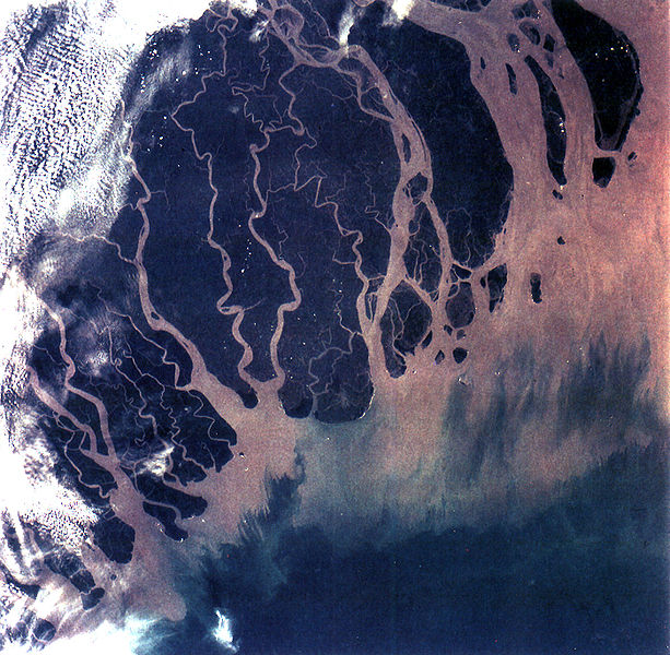
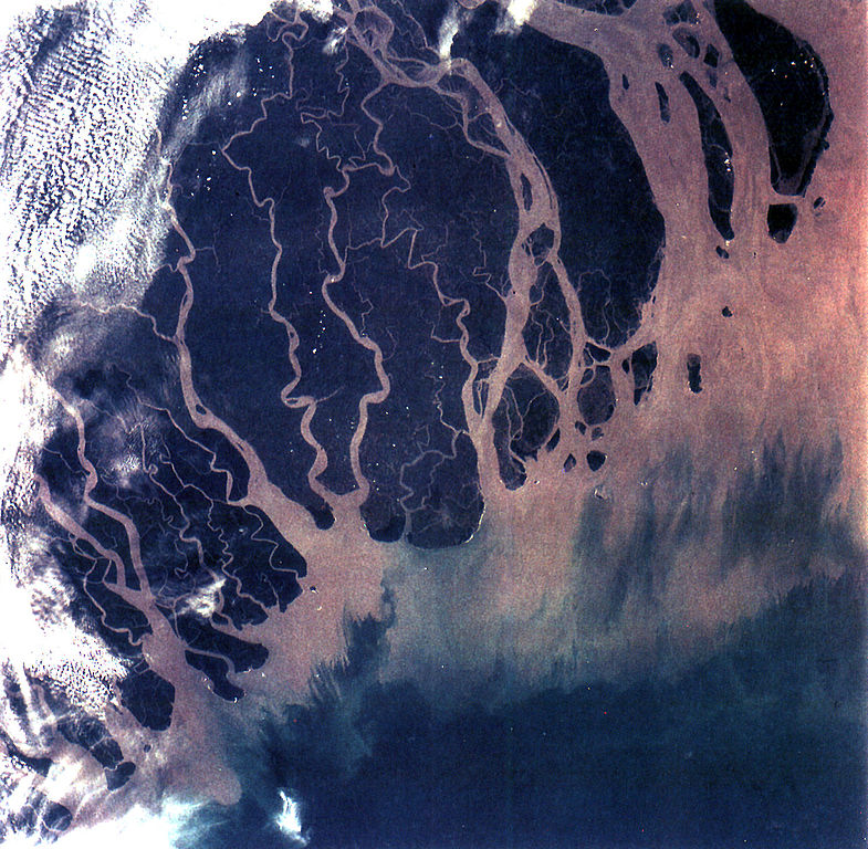
The Ganges River Delta (fig. 5) is the largest inter-tidal delta in the world. With its extensive mangrove mud flats, swamp vegetation and sand dunes, it is characteristic of many tropical and subtropical coasts. The vegetation cushions the shoreline from wind and wave action while the mangrove trees provide a habitat and food for aquatic and terrestrial plant and animal life. The increasing demand for lumber and firewood is outpacing the natural re-growth of the mangrove trees. Space Shuttle photographs, taken over time, permit monitoring of environmental changes in the delta caused by population pressures, and allows mapping of geological changes caused by shifting distributaries and delta growth. As seen in this photograph, the tributaries and distributaries of the Ganges and Brahmaputra Rivers deposit huge amounts of silt and clay that create a shifting maze of waterways and islands in the Bay of Bengal. |
| Data | |
| Font | https://eol.jsc.nasa.gov/SearchPhotos/photo.pl?mission=STS066&roll=92&frame=013 |
| Autor | NASA |
Aquest fitxer ha estat catalogat per Johnson Space Center dels Estats Units d'Amèrica per a l'Administració Nacional d'Aeronàutica i de l'Espai (NASA)en virtut identificat com a: ID del fitxer : STS066-92-013.Els ID dels fitxers i ID alternatius són traduïts de Photo ID .Aquesta etiqueta no indica l'estat dels drets d'autor de la imatge carregada. Cal un senyal de drets d'autor. Vegeu Commons:Sobre les llicències. Altres idiomes:
|
Llicència
| Aquest fitxer és en el domini públic perquè ha estat creat per la NASA. L'avís legal de la NASA diu que «el material de la NASA no està protegit per copyright si no es diu el contrari». (NASA copyright policy page o JPL Image Use Policy). | ||
 |
Atenció:
|
Historial del fitxer
Cliqueu una data/hora per veure el fitxer tal com era aleshores.
| Data/hora | Miniatura | Dimensions | Usuari/a | Comentari | |
|---|---|---|---|---|---|
| actual | 22:07, 25 oct 2005 | | 1.400 × 1.370 (805 Ko) | Brian0918 | GANGES RIVER DELTA, BANGLADESH, INDIA (STS066-92-013). The Ganges River Delta (fig. 5) is the largest inter-tidal delta in the world. With its extensive mangrove mud flats, swamp vegetation and sand dunes, it is characteristic of many tropical and subtr |
Ús del fitxer
La pàgina següent utilitza aquest fitxer:
Ús global del fitxer
Utilització d'aquest fitxer en altres wikis:
- Utilització a ar.wikipedia.org
- Utilització a ast.wikipedia.org
- Utilització a bh.wikipedia.org
- Utilització a bn.wikipedia.org
- Utilització a br.wikipedia.org
- Utilització a cs.wikipedia.org
- Utilització a cy.wikipedia.org
- Utilització a da.wikipedia.org
- Utilització a en.wikipedia.org
- Geography of Bangladesh
- River delta
- Geography of West Bengal
- Water politics
- Geology of Bangladesh
- Ganges water dispute
- Portal:Geography/Featured picture/2009, week 39
- Portal:Geography/Featured picture archive/2009
- Outline of geography
- User:Bettymnz4/Geology of Bangladesh
- Flood pulse concept
- User talk:Vsmith/Archive27
- Deltaic lobe
- Utilització a eo.wikipedia.org
- Utilització a es.wikipedia.org
- Utilització a et.wikipedia.org
- Utilització a eu.wikipedia.org
- Utilització a ext.wikipedia.org
- Utilització a fr.wikipedia.org
- Utilització a gl.wikipedia.org
- Utilització a hif.wikipedia.org
- Utilització a hi.wikipedia.org
Vegeu més usos globals d'aquest fitxer.