Fitxer:German Empire states map.svg

Mida d'aquesta previsualització PNG del fitxer SVG: 496 × 600 píxels. Altres resolucions: 198 × 240 píxels | 397 × 480 píxels | 635 × 768 píxels | 847 × 1.024 píxels | 1.694 × 2.048 píxels | 1.042 × 1.260 píxels.
Fitxer original (fitxer SVG, nominalment 1.042 × 1.260 píxels, mida del fitxer: 2,31 Mo)
| Aquest fitxer i la informació mostrada a continuació provenen del dipòsit multimèdia lliure Wikimedia Commons. |
Resum
| Descripció |
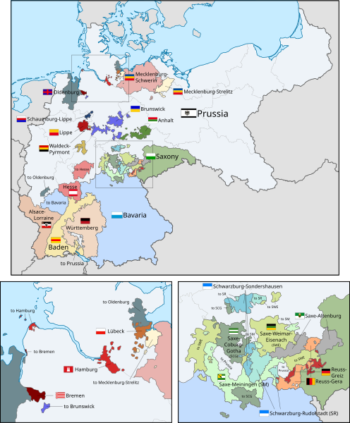
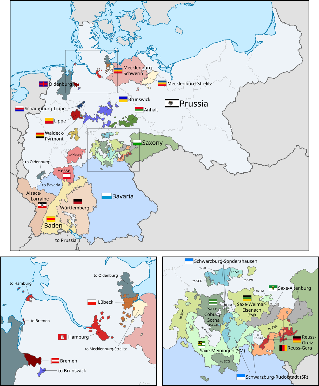
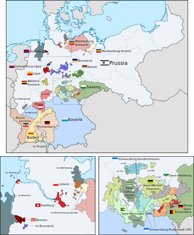
English: A map of the states of the German Empire, showing their location, flags and names in English. |
| Data | |
| Font |
This file was derived from: German Empire blank map.svg: This vector image includes elements that have been taken or adapted from this file: This vector image includes elements that have been taken or adapted from this file: This vector image includes elements that have been taken or adapted from this file: This vector image includes elements that have been taken or adapted from this file: This vector image includes elements that have been taken or adapted from this file: This vector image includes elements that have been taken or adapted from this file: This vector image includes elements that have been taken or adapted from this file: This vector image includes elements that have been taken or adapted from this file: This vector image includes elements that have been taken or adapted from this file: This vector image includes elements that have been taken or adapted from this file: This vector image includes elements that have been taken or adapted from this file: This vector image includes elements that have been taken or adapted from this file: This vector image includes elements that have been taken or adapted from this file: This vector image includes elements that have been taken or adapted from this file: This vector image includes elements that have been taken or adapted from this file: This vector image includes elements that have been taken or adapted from this file: This vector image includes elements that have been taken or adapted from this file: This vector image includes elements that have been taken or adapted from this file: This vector image includes elements that have been taken or adapted from this file: This vector image includes elements that have been taken or adapted from this file: This vector image includes elements that have been taken or adapted from this file: This vector image includes elements that have been taken or adapted from this file: This vector image includes elements that have been taken or adapted from this file: This image includes elements that have been taken or adapted from this file: |
| Autor |
|
| Altres versions |
|
| SVG genesis | Aquesta imatge vectorial ha estat creada amb unknown tool This flag uses embedded text that can be easily translated using a text editor. |


.svg)
.svg)
.svg)
.svg)
.svg)
.svg)
Llicència
Jo, el titular dels drets d'autor d'aquest treball, el public sota la següent llicència:
Aquest fitxer està subjecte a la llicència de Creative Commons Reconeixement i Compartir Igual 3.0 No adaptada.
- Sou lliure de:
- compartir – copiar, distribuir i comunicar públicament l'obra
- adaptar – fer-ne obres derivades
- Amb les condicions següents:
- reconeixement – Heu de donar la informació adequada sobre l'autor, proporcionar un enllaç a la llicència i indicar si s'han realitzat canvis. Podeu fer-ho amb qualsevol mitjà raonable, però de cap manera no suggereixi que l'autor us dóna suport o aprova l'ús que en feu.
- compartir igual – Si modifiqueu, transformeu, o generareu amb el material, haureu de distribuir les vostres contribucions sota una llicència similar o una de compatible com l'original
Code for clickable map
Historial del fitxer
Cliqueu una data/hora per veure el fitxer tal com era aleshores.
| Data/hora | Miniatura | Dimensions | Usuari/a | Comentari | |
|---|---|---|---|---|---|
| actual | 04:43, 24 feb 2019 | | 1.042 × 1.260 (2,31 Mo) | Alphathon | Corrected Brunswick territory accidentally given to Anhalt |
| 16:55, 4 nov 2015 |  | 1.042 × 1.260 (2,39 Mo) | Alphathon | Slight optimisation | |
| 03:33, 4 nov 2015 |  | 1.042 × 1.260 (2,39 Mo) | Alphathon | Another minor tweak | |
| 03:31, 4 nov 2015 |  | 1.042 × 1.260 (2,39 Mo) | Alphathon | Tweaked colours | |
| 00:25, 4 nov 2015 |  | 1.042 × 1.260 (2,39 Mo) | Alphathon | Corrected typo | |
| 13:51, 3 nov 2015 |  | 1.042 × 1.260 (2,39 Mo) | Alphathon | {{Information |Description={{en|A map of the states of the en:German Empire, showing their location, flags and names in English.}} |Source={{Derived from|File:German Empire blank map.svg|display=50}} {{AttribSVG|Flagge Herzogtum Anhalt.svg|David... |
Ús del fitxer
La pàgina següent utilitza aquest fitxer:
Ús global del fitxer
Utilització d'aquest fitxer en altres wikis:
- Utilització a ar.wikipedia.org
- Utilització a ast.wikipedia.org
- Utilització a az.wikipedia.org
- Utilització a en.wikipedia.org
- Utilització a es.wikipedia.org
- Utilització a fi.wikipedia.org
- Utilització a he.wikipedia.org
- Utilització a hu.wikipedia.org
- Utilització a it.wikipedia.org
- Utilització a nl.wikipedia.org
- Utilització a pt.wikipedia.org
- Utilització a sr.wikipedia.org
- Utilització a th.wikipedia.org
- Utilització a zh.wikipedia.org