Fitxer:Havre De Grace Maryland Lighthouse 600.jpg
Havre_De_Grace_Maryland_Lighthouse_600.jpg (400 × 600 píxels, mida del fitxer: 99 Ko, tipus MIME: image/jpeg)
| Aquest fitxer i la informació mostrada a continuació provenen del dipòsit multimèdia lliure Wikimedia Commons. |
Resum
|
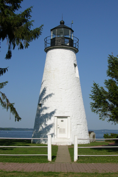
This is an image of a place or building that is listed on the National Register of Historic Places in the United States of America. Its reference number is 76000999. |
Picture of the Concord Point Lighthouse in Havre De Grace, Maryland overlooking the point where the Susquehanna River flows into the Chesapeake Bay. Photo by Derek Ramsey (Ram-Man)
Llicència
You may NOT use this image on your own web site or anywhere else unless you release this image and any derivative works (which may include the web page or other medium where this image is used, if it is not considered a "collective work") by following the terms of one of the following licenses. Any other use will be considered a breach of copyright law. Please do not copy this image illegally by ignoring the terms of the license, as it is not in the public domain.
If you would like special permission to use, license, or purchase the image or prints of the image, or for use in any other fashion, or would simply like a copy of the original file, please contact me or email me first to ask. Please see the non-legalese usage guide for more information.
Note: While you are not required to do so by the license, please consider letting me know when you reuse one of my photograph images, as a courtesy.

|
S'autoritza la còpia, la distribució i la modificació d'aquest document sota els termes de la llicència de documentació lliure GNU versió 1.2, publicada per la Free Software Foundation; sense seccions invariants, ni textos de portada, ni textos de contraportada. S'inclou una còpia d'aquesta llicència en la secció titulada GNU Free Documentation License. | 1.2 només |
- Sou lliure de:
- compartir – copiar, distribuir i comunicar públicament l'obra
- adaptar – fer-ne obres derivades
- Amb les condicions següents:
- reconeixement – Heu de donar la informació adequada sobre l'autor, proporcionar un enllaç a la llicència i indicar si s'han realitzat canvis. Podeu fer-ho amb qualsevol mitjà raonable, però de cap manera no suggereixi que l'autor us dóna suport o aprova l'ús que en feu.
- compartir igual – Si modifiqueu, transformeu, o generareu amb el material, haureu de distribuir les vostres contribucions sota una llicència similar o una de compatible com l'original
| Posició de l'objecte | | Aquesta i altres imatges properes a: OpenStreetMap |
|---|
Historial del fitxer
Cliqueu una data/hora per veure el fitxer tal com era aleshores.
| Data/hora | Miniatura | Dimensions | Usuari/a | Comentari | |
|---|---|---|---|---|---|
| actual | 05:54, 17 jul 2005 | | 400 × 600 (99 Ko) | Ram-Man | Picture of the Lighthouse in Havre De Grace, Maryland overlooking the point where the Susquehanna River flows into the Chesapeake Bay. Photo by Derek Ramsey ([[w |
Ús del fitxer
La pàgina següent utilitza aquest fitxer:
Ús global del fitxer
Utilització d'aquest fitxer en altres wikis:
- Utilització a ar.wikipedia.org
- Utilització a arz.wikipedia.org
- Utilització a ceb.wikipedia.org
- Utilització a ce.wikipedia.org
- Utilització a cy.wikipedia.org
- Utilització a de.wikipedia.org
- Utilització a en.wikipedia.org
- Utilització a en.wikivoyage.org
- Utilització a es.wikipedia.org
- Utilització a eu.wikipedia.org
- Utilització a fa.wikipedia.org
- Utilització a fr.wikipedia.org
- Utilització a hu.wikipedia.org
- Utilització a it.wikipedia.org
- Utilització a ja.wikipedia.org
- Utilització a ky.wikipedia.org
- Utilització a lld.wikipedia.org
- Utilització a nl.wikipedia.org
- Utilització a pl.wikipedia.org
- Utilització a pt.wikipedia.org
- Utilització a sco.wikipedia.org
- Utilització a sh.wikipedia.org
- Utilització a sr.wikipedia.org
- Utilització a tr.wikipedia.org
- Utilització a tt.wikipedia.org
- Utilització a uk.wikipedia.org
- Utilització a ur.wikipedia.org
- Utilització a uz.wikipedia.org
- Utilització a vo.wikipedia.org
- Utilització a www.wikidata.org
- Utilització a zh-min-nan.wikipedia.org
- Utilització a zh.wikipedia.org