Fitxer:Hitler-Headquarters-Europe.png

Fitxer original (1.120 × 790 píxels, mida del fitxer: 473 Ko, tipus MIME: image/png)
| Aquest fitxer i la informació mostrada a continuació provenen del dipòsit multimèdia lliure Wikimedia Commons. |
Resum
| Descripció |
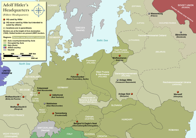
Map of Adolf Hitler's Headquarters (Führer Headquarters) in Europe 1933-1945. Countries that were part of the Axis/annexed by Axis are colored dark green (Germany, Austria, Hungary, Romania & Italy etc). |
| Data | |
| Font | Self-made, based on information from references below |
| Autor | User:Dna-Dennis |
| Permís (Com reutilitzar aquest fitxer) |
CC, see below. The map is completely unrestricted for any Wikipedia/Wikimedia project. If you have any opinions/suggestions, please contact me here on my talk page. |
| Altres versions |
|


.png)

|
Aquesta imatge (de tipus historical map) s'hauria de tornar a crear utilitzant gràfics vectorials com ara un fitxer SVG. Això té diversos avantatges; en trobareu més informació a Commons:Media for cleanup. Si ja disposeu d'una versió d'aquesta imatge en format SVG, us preguem que la pengeu; després, reemplaceu aquesta plantilla amb la plantilla {{Vector version available|nom nou de la imatge.svg}} en aquesta imatge.
|
Llicència
- Sou lliure de:
- compartir – copiar, distribuir i comunicar públicament l'obra
- adaptar – fer-ne obres derivades
- Amb les condicions següents:
- reconeixement – Heu de donar la informació adequada sobre l'autor, proporcionar un enllaç a la llicència i indicar si s'han realitzat canvis. Podeu fer-ho amb qualsevol mitjà raonable, però de cap manera no suggereixi que l'autor us dóna suport o aprova l'ús que en feu.
References
- Beevor, Antony, Berlin - The Downfall 1945
- Eberle, Henrik and Uhl, Matthias, The Unknown Hitler
- Hansen, Hans-Josef: Felsennest - Das vergessene Führerhauptquartier in der Eifel. Bau, Nutzung, Zerstörung. Aachen 2006, Helios-Verlag, ISBN 3-938208-21-X.
- Kuffner, Alexander: Zeitreiseführer Eifel 1933-45. Helios, Aachen 2007, ISBN 978-3-938208-42-7.
- Raiber, Richard, Guide to Hitler's Headquarters, After the Battle archive copy at the Wayback Machine, No.19, Special Edition, Battle of Britain International Ltd, 1977, London
- Ramsey, Winston G. (editor) & Posch, Tom (researcher), The Berlin Führerbunker: The Thirteenth Hole, After the Battle archive copy at the Wayback Machine, No.61, Special Edition, Battle of Britain International Ltd, 1988, London
- von Loringhoven, Bernd Freytag/d’Alançon, François: Mit Hitler im Bunker. Aufzeichnungen aus dem Führerhauptquartier Juli 1944 – April 1945. Berlin 2005, wjs-Verlag, ISBN 3-937989-14-5.
- Schulz, Alfons: Drei Jahre in der Nachrichtenzentrale des Führerhauptquartiers. Christiana-Verlag, Stein am Rhein. 2. Aufl. 1997. ISBN 3-7171-1028-4.
- Seidler, Franz W./Zeigert, Dieter : Die Führerhauptquartiere. Anlagen und Planungen im Zweiten Weltkrieg. München: Herbig 2000. ISBN 3-7766-2154-0.
Notes on the individual headquarters
- Adlerhorst (Guide to Hitler's Headquarters, p.51)
- Anlage Mitte (Guide to Hitler's Headquarters, p.48)
- Anlage Süd (Guide to Hitler's Headquarters, p.48)
- Berghof/Eagle's nest (Guide to Hitler's Headquarters, p.2) - please note that the "Eagle's nest" was rarely used
- Bärenhöhle (www.bundesarchiv.de)
- Felsennest (Guide to Hitler's Headquarters, p.4)
- Führerbunker (After The Battle, No.61 (entire))
- Tannenberg (Guide to Hitler's Headquarters, p.18)
- Waldwiese (www.bundesarchiv.de)
- Wasserburg (www.bundesarchiv.de)
- Werwolf (Guide to Hitler's Headquarters, p.48)
- Wolfsschanze (Guide to Hitler's Headquarters, p.28)
- Wolfsschlucht I (Guide to Hitler's Headquarters, p.10)
- Wolfsschlucht II (Guide to Hitler's Headquarters, p.49)
Historial del fitxer
Cliqueu una data/hora per veure el fitxer tal com era aleshores.
| Data/hora | Miniatura | Dimensions | Usuari/a | Comentari | |
|---|---|---|---|---|---|
| actual | 10:19, 3 abr 2012 | | 1.120 × 790 (473 Ko) | Asav | Wehrwolf -> Werwolf (Correct name, see "Naming" section on en.wp) |
| 05:54, 20 des 2007 |  | 1.120 × 790 (537 Ko) | Dna-webmaster~commonswiki | completely new version with 1942 borders | |
| 01:32, 17 des 2007 |  | 1.120 × 790 (408 Ko) | Dna-webmaster~commonswiki | updated map - please suggest changes before making any bold moves, please | |
| 19:25, 10 des 2007 |  | 1.096 × 704 (37 Ko) | Matthead | Modified version, file size reduced, country coloring removed (countries as of 2007 were not involved in WW2) | |
| 06:27, 21 oct 2007 |  | 1.120 × 790 (407 Ko) | Dna-webmaster~commonswiki | new version with new colors | |
| 16:11, 16 oct 2007 |  | 1.120 × 790 (447 Ko) | Dna-webmaster~commonswiki | new version | |
| 22:46, 14 oct 2007 |  | 1.120 × 790 (423 Ko) | Dna-webmaster~commonswiki | quick update | |
| 22:38, 14 oct 2007 |  | 1.120 × 790 (425 Ko) | Dna-webmaster~commonswiki | {{Information |Description=Map of Adolf Hitler's Headquarters (Führer Headquarters) in Europe 1933-1945.<br><br> For more detailed information, please see below. |Source=Self-made |Date=October 14, 2007 |Author=[http://en.wikipedia.org/wiki/User:Dna-webm |
Ús del fitxer
Les 2 pàgines següents utilitzen aquest fitxer:
Ús global del fitxer
Utilització d'aquest fitxer en altres wikis:
- Utilització a ar.wikipedia.org
- Utilització a ast.wikipedia.org
- Utilització a ba.wikipedia.org
- Utilització a bg.wikipedia.org
- Utilització a cs.wikipedia.org
- Utilització a da.wikipedia.org
- Utilització a el.wikipedia.org
- Utilització a en.wikipedia.org
- Utilització a es.wikipedia.org
- Utilització a et.wikipedia.org
- Utilització a fi.wikipedia.org
- Utilització a fr.wikipedia.org
- Utilització a he.wikipedia.org
- Utilització a id.wikipedia.org
- Utilització a it.wikipedia.org
- Utilització a ja.wikipedia.org
- Utilització a ko.wikipedia.org
- Utilització a ms.wikipedia.org
- Utilització a nl.wikipedia.org
- Utilització a no.wikipedia.org
- Utilització a pl.wikipedia.org
Vegeu més usos globals d'aquest fitxer.