Fitxer:Ice-floe params hg.png

Mida d'aquesta previsualització: 800 × 392 píxels. Altres resolucions: 320 × 157 píxels | 640 × 314 píxels | 1.024 × 502 píxels | 1.280 × 628 píxels | 2.800 × 1.373 píxels.
Fitxer original (2.800 × 1.373 píxels, mida del fitxer: 115 Ko, tipus MIME: image/png)
| Aquest fitxer i la informació mostrada a continuació provenen del dipòsit multimèdia lliure Wikimedia Commons. |
| Descripció |
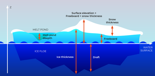
English: Section through an ice floe with parameters used in glaciological research to quantify and describe the coverage of sea ice
Русский: Сечение льдины и её параетры, используемые в гляциологии для описания и количественных оценок покрытия морей льдом.
|
| Data | |
| Font | own work, redrawn from a draft by Valerij Cysko under the supervision of Dr. Christian Haas, geophysicist at Alfred Wegener Institute for Polar and Marine Research, Bremerhaven |
| Autor | Amanda Grobe & Hannes Grobe 21:53, 12 August 2006 (UTC), Alfred Wegener Institute for Polar and Marine Research, Bremerhaven, Germany |
| Permís (Com reutilitzar aquest fitxer) |
own work, share alike, attribution required (Creative Commons CC-BY-SA-2.5) |
| Altres versions | original grafic in Intaglio format available from the author |
Jo, el titular dels drets d'autor d'aquest treball, el public sota la següent llicència:
Aquest fitxer està publicat sota la llicència de Creative Commons Reconeixement i Compartir Igual 2.5 Genèrica.
- Sou lliure de:
- compartir – copiar, distribuir i comunicar públicament l'obra
- adaptar – fer-ne obres derivades
- Amb les condicions següents:
- reconeixement – Heu de donar la informació adequada sobre l'autor, proporcionar un enllaç a la llicència i indicar si s'han realitzat canvis. Podeu fer-ho amb qualsevol mitjà raonable, però de cap manera no suggereixi que l'autor us dóna suport o aprova l'ús que en feu.
- compartir igual – Si modifiqueu, transformeu, o generareu amb el material, haureu de distribuir les vostres contribucions sota una llicència similar o una de compatible com l'original

|
Aquesta imatge (de tipus geology) s'hauria de tornar a crear utilitzant gràfics vectorials com ara un fitxer SVG. Això té diversos avantatges; en trobareu més informació a Commons:Media for cleanup. Si ja disposeu d'una versió d'aquesta imatge en format SVG, us preguem que la pengeu; després, reemplaceu aquesta plantilla amb la plantilla {{Vector version available|nom nou de la imatge.svg}} en aquesta imatge.
|
Historial del fitxer
Cliqueu una data/hora per veure el fitxer tal com era aleshores.
| Data/hora | Miniatura | Dimensions | Usuari/a | Comentari | |
|---|---|---|---|---|---|
| actual | 23:29, 24 set 2023 | | 2.800 × 1.373 (115 Ko) | Beao | Cropped 13 % vertically using CropTool with lossless mode. Removed watermark. |
| 01:10, 21 abr 2022 |  | 2.800 × 1.576 (130 Ko) | RASPBERRY VIBE | Image resolution increase, data structuring. | |
| 06:42, 21 ago 2006 |  | 675 × 376 (157 Ko) | Hgrobe | {{Information| |Description=Section through an ice floe with parameters used in glaciological research to quantify and describe the coverage of sea ice * '''Ice thickness''': total thickness of the ice floe (draft + freeboard) * '''Freeboard''': part of t | |
| 06:34, 21 ago 2006 |  | 783 × 559 (163 Ko) | Hgrobe | {{Information| |Description=Section through an ice floe with parameters used in glaciological research to quantify and describe the coverage of sea ice * '''Ice thickness''': total thickness of the ice floe (draft + freeboard) * '''Freeboard''': part of t | |
| 23:53, 12 ago 2006 |  | 1.006 × 557 (261 Ko) | Hgrobe | {{Information| |Description=Section through an ice floe with parameters used in glaciological research to quantify and describe the coverage of sea ice |Source=own work |Date=2006-08-08 |Author=~~~~ |Permission=Own work, share alike, attribution required |
Ús del fitxer
Les 2 pàgines següents utilitzen aquest fitxer:
Ús global del fitxer
Utilització d'aquest fitxer en altres wikis:
- Utilització a be.wikipedia.org
- Utilització a bn.wikipedia.org
- Utilització a cv.wikipedia.org
- Utilització a de.wikipedia.org
- Utilització a el.wikipedia.org
- Utilització a en.wikipedia.org
- Utilització a en.wiktionary.org
- Utilització a es.wikipedia.org
- Utilització a it.wikipedia.org
- Utilització a ja.wikipedia.org
- Utilització a ko.wikipedia.org
- Utilització a mnw.wiktionary.org
- Utilització a nl.wikipedia.org
- Utilització a nn.wikipedia.org
- Utilització a no.wikipedia.org
- Utilització a simple.wikipedia.org
- Utilització a uk.wikipedia.org
- Utilització a zh.wikipedia.org
- Utilització a zh.wiktionary.org