Fitxer:Kiplingsindia.jpg

Fitxer original (802 × 663 píxels, mida del fitxer: 114 Ko, tipus MIME: image/jpeg)
| Aquest fitxer i la informació mostrada a continuació provenen del dipòsit multimèdia lliure Wikimedia Commons. |
Resum
| Descripció |
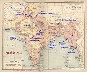
ResumThis is a low-resolution (40% of original) scanned image of the map, "Politial Divisions of the Indian Empire" from the Imperial Gazeteer of India (volume 26, Atlas), published by the Oxford University Press, 1909. The map image was scanned and then annotated by me (Sanjay Tiwari 18:24, 30 September 2006 (UTC)) |
||||||
| Font | Treball propi | ||||||
| Autor | User Sanjay Tiwari on en.wikipedia | ||||||
| Permís (Com reutilitzar aquest fitxer) |
|
||||||
| Altres versions |
Originally from en.wikipedia; description page is (was) here * 18:24, 30 September 2006 [[:en:User:Sanjay Tiwari|Sanjay Tiwari]] 880×680 (126,459 bytes) <span class="comment">(This is a low-resolution (40% of original) scanned image of the map, "Politial Divisions of the Indian Empire" from the ''Imperial Gazeteer of India'' (volume 26, Atlas), published by the Oxford University Press, 1909. The map image was scanned and the)</span> |
||||||
(Uploaded using CommonsHelper or PushForCommons)
Llicència
|
Aquest material està en domini públic als Estats Units i als altres països on el dret d'autor s'estén per 70 anys (o menys) després de la mort de l'autor.
| |
| Aquest fitxer està identificat com a lliure de restriccions conegudes sota la llei de drets d'autor, inclosos els drets veïns. | |
Registre original de càrregues
- 2007-05-14 07:25 Kintetsubuffalo 802×663× (117058 bytes) trimmed to make edges equal
- 2006-09-30 18:24 Sanjay Tiwari 880×680× (126459 bytes) This is a low-resolution (40% of original) scanned image of the map, "Politial Divisions of the Indian Empire" from the ''Imperial Gazeteer of India'' (volume 26, Atlas), published by the Oxford University Press, 1909. The map image was scanned and the
Historial del fitxer
Cliqueu una data/hora per veure el fitxer tal com era aleshores.
| Data/hora | Miniatura | Dimensions | Usuari/a | Comentari | |
|---|---|---|---|---|---|
| actual | 15:39, 28 març 2016 | | 802 × 663 (114 Ko) | OgreBot | (BOT): Uploading old version of file from en.wikipedia; originally uploaded on 2007-05-14 07:25:05 by Kintetsubuffalo |
| 15:39, 28 març 2016 |  | 880 × 680 (123 Ko) | OgreBot | (BOT): Uploading old version of file from en.wikipedia; originally uploaded on 2006-09-30 18:24:12 by Sanjay Tiwari | |
| 22:17, 13 nov 2006 |  | 776 × 600 (95 Ko) | Chechof | {{Information| |Description= == Summary == This is a low-resolution (40% of original) scanned image of the map, "Politial Divisions of the Indian Empire" from the ''Imperial Gazeteer of India'' (volume 26, Atlas), published by the Oxford University Press |
Ús del fitxer
La pàgina següent utilitza aquest fitxer:
Ús global del fitxer
Utilització d'aquest fitxer en altres wikis:
- Utilització a el.wikipedia.org
- Utilització a en.wikipedia.org
- Utilització a es.wikipedia.org
- Utilització a gl.wikipedia.org
- Utilització a hi.wikipedia.org
- Utilització a hu.wikipedia.org
- Utilització a ja.wikipedia.org
- Utilització a pt.wikipedia.org
- Utilització a tt.wikipedia.org
- Utilització a vi.wikipedia.org