Fitxer:Lockheed 8 Sirius 'Tingmissartoq' at the National Air and Space Museum, Washington DC.jpg

Fitxer original (1.600 × 1.066 píxels, mida del fitxer: 503 Ko, tipus MIME: image/jpeg)
| Aquest fitxer i la informació mostrada a continuació provenen del dipòsit multimèdia lliure Wikimedia Commons. |
| Descripció |
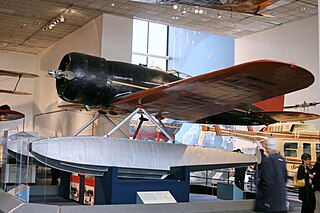
Every possible space in the aircraft was utilized, including the wings and floats, which contained the gasoline tanks. There was plenty of emergency equipment in case the Lindberghs had to make a forced landing in the frozen wilderness. From New York, the Lindberghs flew up the eastern border of Canada to Hopedale, Labrador. From Hopedale they made the first major overwater hop, 650 miles to Godthaab, Greenland, where the Sirius acquired its name—Tingmissartoq, which in Eskimo means "one who flies like a big bird." After crisscrossing Greenland to Baffin Island and back, and then on to Iceland, the Lindberghs proceeded to the major cities of Europe and as far east as Moscow, down the west coast of Africa, and across the South Atlantic to South America. where they flew down the Amazon, and then north through Trinidad and Barbados and back to the United States. They returned to New York on December 19, having traveled 30,000 miles to four continents and twenty-one countries. The information gained from the trip proved invaluable in planning commercial air transport routes for the North and South Atlantic. The aircraft was in the American Museum of Natural History in New York City until 1955. The AirForce Museum in Dayton, Ohio, then acquired it and transferred it to the Smithsonian in 1959. collections.nasm.si.edu/code/emuseum.asp?profile=objects&... |
| Data | |
| Font | Lockheed 8 Sirius "Tingmissartoq" |
| Autor | Cliff from I now live in Arlington, VA (Outside Washington DC), USA |
| Posició de la càmera | | Aquesta i altres imatges properes a: OpenStreetMap |
|---|
Llicència
- Sou lliure de:
- compartir – copiar, distribuir i comunicar públicament l'obra
- adaptar – fer-ne obres derivades
- Amb les condicions següents:
- reconeixement – Heu de donar la informació adequada sobre l'autor, proporcionar un enllaç a la llicència i indicar si s'han realitzat canvis. Podeu fer-ho amb qualsevol mitjà raonable, però de cap manera no suggereixi que l'autor us dóna suport o aprova l'ús que en feu.
| This image was originally posted to Flickr by cliff1066™ at https://www.flickr.com/photos/28567825@N03/3344241041. It was reviewed on 15 de novembre de 2009 by FlickreviewR and was confirmed to be licensed under the terms of the cc-by-2.0. |
Historial del fitxer
Cliqueu una data/hora per veure el fitxer tal com era aleshores.
| Data/hora | Miniatura | Dimensions | Usuari/a | Comentari | |
|---|---|---|---|---|---|
| actual | 20:01, 15 nov 2009 | | 1.600 × 1.066 (503 Ko) | Geo Swan | {{Information |Description=Every possible space in the aircraft was utilized, including the wings and floats, which contained the gasoline tanks. There was plenty of emergency equipment in case the Lindberghs had to make a forced landing in the frozen wil |
Ús del fitxer
Les 2 pàgines següents utilitzen aquest fitxer:
Ús global del fitxer
Utilització d'aquest fitxer en altres wikis:
- Utilització a ar.wikipedia.org
- Utilització a ast.wikipedia.org
- Utilització a en.wikipedia.org
- Utilització a es.wikipedia.org
- Utilització a fa.wikipedia.org
- Utilització a fr.wikipedia.org
- Utilització a gl.wikipedia.org
- Utilització a id.wikipedia.org
- Utilització a ja.wikipedia.org
- Utilització a no.wikipedia.org
- Utilització a pt.wikipedia.org
- Utilització a vi.wikipedia.org
- Utilització a www.wikidata.org