Fitxer:Map Praying Mantis.png
No hi ha cap versió amb una resolució més gran.
Map_Praying_Mantis.png (517 × 378 píxels, mida del fitxer: 152 Ko, tipus MIME: image/png)
| Aquest fitxer i la informació mostrada a continuació provenen del dipòsit multimèdia lliure Wikimedia Commons. |
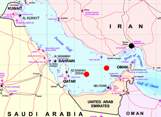
Map of Persian Gulf - marks are approxymate positions of the iranian Oilrigs Sassan (left) and Sirri (right) and the city of Bandar Abbas (black). Both rigs were destroyed while Operation Praying Mantis on April 18, 1988
The map is a part of Image:MiddleEast.png, which is marked as:
Subject: Middle East map
Source: NIMA [1] archive copy at the Wayback Machine
Aquesta obra és en el domini públic als Estats Units perquè és una obra del govern federal dels Estats Units sota els termes del Títol 17, Capítol 1, Secció 105 del Codi dels EUA. Vegeu drets d'autor.
Nota: Això només s'aplica a obres del Govern Federal i no a les dels estats individuals ni cap altra subdivisió administrativa. Aquesta plantilla tampoc no s'aplica a dissenys de segells de correus publicats pel Servei Postal dels Estats Units des de 1978 (vegeu 206.02(b) of Compendium II: Copyright Office Practices).
|
 | |
| Aquest fitxer està identificat com a lliure de restriccions conegudes sota la llei de drets d'autor, inclosos els drets veïns. | ||
Historial del fitxer
Cliqueu una data/hora per veure el fitxer tal com era aleshores.
| Data/hora | Miniatura | Dimensions | Usuari/a | Comentari | |
|---|---|---|---|---|---|
| actual | 22:35, 29 abr 2006 | | 517 × 378 (152 Ko) | Schlendrian | Map of Persian Gulf - marks are approxymate positions of the iranian Oilrigs ''Sassan'' (left) and ''Sirri'' (right) and the city of Bandar Abbas (black). Both rigs were destroyed while Operation Praying Mantis on April 18, 1988 The map is a part of [[:I |
Ús del fitxer
Les 2 pàgines següents utilitzen aquest fitxer:
Ús global del fitxer
Utilització d'aquest fitxer en altres wikis:
- Utilització a en.wikipedia.org
- Utilització a fa.wikipedia.org
- Utilització a fr.wikipedia.org
- Utilització a sv.wikipedia.org