Fitxer:Map of Naqsh-e Rostam.jpg
No hi ha cap versió amb una resolució més gran.
Map_of_Naqsh-e_Rostam.jpg (717 × 579 píxels, mida del fitxer: 179 Ko, tipus MIME: image/jpeg)
| Aquest fitxer i la informació mostrada a continuació provenen del dipòsit multimèdia lliure Wikimedia Commons. |
Resum
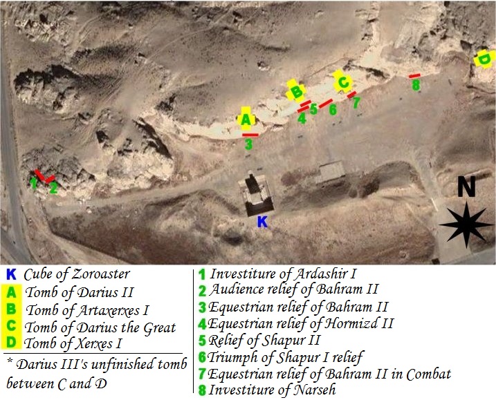
| Descripció | map of archeological site of Naqsh-e Rostam (Iran, fars Province, city of Marvdasht) |
| Data | |
| Font | Own work using NASA's satellite picture of the place and an artifact sheme according to belgium archeologist Louis Vanden Berghe. |
| Autor | Pentocelo |
| Altres versions | with french legends Image:Map of Naqsh-e Rostam (fr).jpg |
.jpg)
Llicència
| Jo, el titular del copyright d'aquesta obra, l'allibero al domini públic. Això s'aplica a tot el món. En alguns països això pot no ser legalment possible, en tal cas: Jo faig concessió a tothom del dret d'usar aquesta obra per a qualsevol propòsit, sense cap condició llevat d'aquelles requerides per la llei. |
Historial del fitxer
Cliqueu una data/hora per veure el fitxer tal com era aleshores.
| Data/hora | Miniatura | Dimensions | Usuari/a | Comentari | |
|---|---|---|---|---|---|
| actual | 06:56, 27 feb 2011 | | 717 × 579 (179 Ko) | Dr. Persi | I took this file from the original work done by the User Pentocelo. This is his original work and therefore the credit belongs to him. He however uploaded the file as no copyright, enabling me to improve his original version. He has created two versions o |
| 21:58, 6 feb 2008 |  | 717 × 579 (75 Ko) | Pentocelo~commonswiki | == Description == {{Information |Description= map of archeological site of Naqsh-e Rostam (Iran, fars Province, city of Marvdasht) |Source= Own work using NASA's satellite picture of the place and an artifact sheme according to belgium archeologist Louis | |
| 21:26, 6 feb 2008 |  | 721 × 624 (83 Ko) | Pentocelo~commonswiki | {{Information |Description= map of archeological site of Naqsh-e Rostam (Iran, fars Province, city of Marvdasht) |Source= Own work using NASA's satellite picture of the place and an artifact sheme according to belgium archeologist Louis Vanden Berghe. |Da |
Ús del fitxer
La pàgina següent utilitza aquest fitxer:
Ús global del fitxer
Utilització d'aquest fitxer en altres wikis:
- Utilització a de.wikivoyage.org
- Utilització a en.wikipedia.org
- Utilització a es.wikipedia.org
- Utilització a it.wikipedia.org
- Utilització a sl.wikipedia.org
- Utilització a vi.wikipedia.org