Fitxer:Map of the Territory of the Brigantes.svg

Mida d'aquesta previsualització PNG del fitxer SVG: 424 × 600 píxels. Altres resolucions: 170 × 240 píxels | 339 × 480 píxels | 543 × 768 píxels | 724 × 1.024 píxels | 1.448 × 2.048 píxels | 744 × 1.052 píxels.
Fitxer original (fitxer SVG, nominalment 744 × 1.052 píxels, mida del fitxer: 149 Ko)
| Aquest fitxer i la informació mostrada a continuació provenen del dipòsit multimèdia lliure Wikimedia Commons. |
| Descripció |
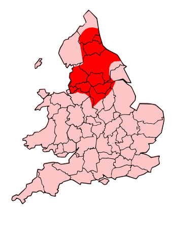
English: County map of England & Wales, overlaid with Territory of the Romano-British Brigantes Tribe of Northern England. |
| Data | (UTC) |
| Font | |
| Autor |
|
| Permís (Com reutilitzar aquest fitxer) |
Jo, el titular dels drets d'autor d'aquest treball, el public sota la següent llicència: Aquest fitxer està subjecte a la llicència de Creative Commons Reconeixement i Compartir Igual 3.0 No adaptada.
|
| Altres versions | Derivative works of this file: Map of the Territory of the Carvetii.svg |
| Això és una imatge retocada, cosa que vol dir que ha estat alterada digitalment de la seva versió original. Modificacions: Revised to show territory of the Brigantes. L'original es pot veure a: England Celtic tribes - North and Midlands.png:
|
Registre original de càrregues
This image is a derivative work of the following images:
- File:England_Celtic_tribes_-_North_and_Midlands.png licensed with Cc-by-sa-3.0
- 2009-07-29T23:43:34Z Thomas Gun 296x495 (27459 Bytes) == Summary == {{Information |Description=Image depicting the Celts of North and Midland England, pre-[[Roman Britain]] times. I created this myself, under the guidance (to find location of them) of [http://www.roman-britain.o
Uploaded with derivativeFX
Historial del fitxer
Cliqueu una data/hora per veure el fitxer tal com era aleshores.
| Data/hora | Miniatura | Dimensions | Usuari/a | Comentari | |
|---|---|---|---|---|---|
| actual | 22:25, 16 oct 2009 | | 744 × 1.052 (149 Ko) | Jpb1301 | {{Information |Description=County map of England & Wales, overlaid with Territory of the Romano-British Brigantes Tribe of Northern England. |Source=*File:England_Celtic_tribes_-_North_and_Midlands.png |Date=2009-10-16 20:19 (UTC) |Author=*[[:File:E |
Ús del fitxer
La pàgina següent utilitza aquest fitxer:
Ús global del fitxer
Utilització d'aquest fitxer en altres wikis:
- Utilització a bg.wikipedia.org
- Utilització a br.wikipedia.org
- Utilització a cy.wikipedia.org
- Utilització a de.wikipedia.org
- Utilització a en.wikipedia.org
- Utilització a es.wikipedia.org
- Utilització a eu.wikipedia.org
- Utilització a fi.wikipedia.org
- Utilització a fr.wikipedia.org
- Utilització a fy.wikipedia.org
- Utilització a id.wikipedia.org
- Utilització a ka.wikipedia.org
- Utilització a ko.wikipedia.org
- Utilització a la.wikipedia.org
- Utilització a nds.wikipedia.org
- Utilització a nl.wikipedia.org
- Utilització a nn.wikipedia.org
- Utilització a no.wikipedia.org
- Utilització a ru.wikipedia.org
- Utilització a sh.wikipedia.org
- Utilització a simple.wikipedia.org
- Utilització a sr.wikipedia.org
- Utilització a xmf.wikipedia.org