Fitxer:Maricopa County Incorporated and Planning areas Scottsdale highlighted.svg

Mida d'aquesta previsualització PNG del fitxer SVG: 694 × 599 píxels. Altres resolucions: 278 × 240 píxels | 556 × 480 píxels | 889 × 768 píxels | 1.185 × 1.024 píxels | 2.371 × 2.048 píxels | 940 × 812 píxels.
Fitxer original (fitxer SVG, nominalment 940 × 812 píxels, mida del fitxer: 1,05 Mo)
| Aquest fitxer i la informació mostrada a continuació provenen del dipòsit multimèdia lliure Wikimedia Commons. |
Resum
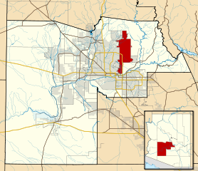
| Descripció | This map shows the incorporated areas and Indian reservation boundaries in Maricopa County, Arizona, along with water bodies and major highways and roads. Scottsdale is highlighted in red. Other incorporated cities are shown in gray, planning area borders for these cities and Indian reservation borders are shown as solid black lines. Changes from Previous Version: Updated the maps to include water bodies and to make "less boring" than the plain black/white/gray maps. Format was updated to match standards laid out by WikiProject Maps/Conventions. Map data is based on data from the following Webpage: Maricopa County Interactive GIS Map. I created this map in Inkscape. |
| Data | |
| Font | My own work, based on government information |
| Autor | Ixnayonthetimmay |
| Permís (Com reutilitzar aquest fitxer) |
Public Domain |
| Altres versions | See Category:Maps of Maricopa County for other versions of this image. |
Llicència
| Jo, el titular del copyright d'aquesta obra, l'allibero al domini públic. Això s'aplica a tot el món. En alguns països això pot no ser legalment possible, en tal cas: Jo faig concessió a tothom del dret d'usar aquesta obra per a qualsevol propòsit, sense cap condició llevat d'aquelles requerides per la llei. |
Historial del fitxer
Cliqueu una data/hora per veure el fitxer tal com era aleshores.
| Data/hora | Miniatura | Dimensions | Usuari/a | Comentari | |
|---|---|---|---|---|---|
| actual | 08:41, 20 maig 2011 | | 940 × 812 (1,05 Mo) | Ixnayonthetimmay | Uploading new version |
| 06:39, 30 ago 2008 |  | 900 × 800 (413 Ko) | Ixnayonthetimmay | == Summary == {{Information |Description=This map shows the incorporated areas and unincorporated areas in Maricopa County, Arizona. [[:en:Paloma, Arizona|Pa | |
| 02:05, 16 set 2007 |  | 900 × 800 (384 Ko) | Ixnayonthetimmay | {{Information |Description= |Source= |Date= |Author= |Permission= |other_versions= }} | |
| 12:13, 28 maig 2007 |  | 900 × 780 (329 Ko) | Ixnayonthetimmay | ||
| 03:15, 22 maig 2007 |  | 900 × 780 (318 Ko) | Ixnayonthetimmay | ||
| 07:24, 30 gen 2007 |  | 904 × 758 (177 Ko) | Ixnayonthetimmay | {{Information |Description=This map shows the incorporated areas in Maricopa County, Arizona, highlighting Scottsdale in red. It also shows the boundaries for |
Ús del fitxer
La pàgina següent utilitza aquest fitxer:
Ús global del fitxer
Utilització d'aquest fitxer en altres wikis:
- Utilització a ar.wikipedia.org
- Utilització a arz.wikipedia.org
- Utilització a br.wikipedia.org
- Utilització a ceb.wikipedia.org
- Utilització a de.wikipedia.org
- Utilització a el.wikipedia.org
- Utilització a eo.wikipedia.org
- Utilització a eu.wikipedia.org
- Utilització a fa.wikipedia.org
- Utilització a fr.wikipedia.org
- Utilització a ga.wikipedia.org
- Utilització a gl.wikipedia.org
- Utilització a ht.wikipedia.org
- Utilització a hu.wikipedia.org
- Utilització a id.wikipedia.org
- Utilització a it.wikipedia.org
- Utilització a ja.wikipedia.org
- Utilització a kw.wikipedia.org
- Utilització a mg.wikipedia.org
- Utilització a ms.wikipedia.org
- Utilització a pms.wikipedia.org
- Utilització a ro.wikipedia.org
- Utilització a sr.wikipedia.org
- Utilització a sv.wikipedia.org
- Utilització a sw.wikipedia.org
- Utilització a tr.wikipedia.org
- Utilització a tt.wikipedia.org
- Utilització a ur.wikipedia.org
- Utilització a vi.wikipedia.org
- Utilització a vo.wikipedia.org
- Utilització a www.wikidata.org
- Utilització a zh.wikipedia.org