Fitxer:Moorea vue par Sentinel 2 (cropped).jpg
Fitxer original (1.038 × 885 píxels, mida del fitxer: 760 Ko, tipus MIME: image/jpeg)
| Aquest fitxer i la informació mostrada a continuació provenen del dipòsit multimèdia lliure Wikimedia Commons. |
Resum
| Descripció |
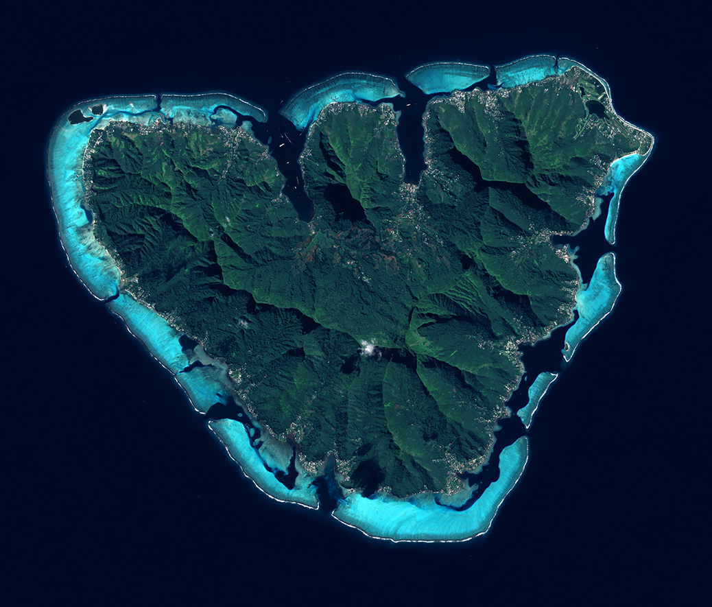
English: L'ile de Moorea vue par le satellite Sentinel 2, le 21 juin 2021.
Moorea est une ile du Pacifique Sud situee dans l'archipel de la Societe en Polynesie francaise. Elle est connue pour ses sommets volcaniques abrupts et ses plages de sable. La mission Sentinel-2 fait partie du programme d’observation et de surveillance de la Terre, Copernicus, conduit par l'Union Europeenne. Grace aux 2 satellites Sentinel-2A (2015) et Sentinel-2B (2017), tous les 5 jours, la mission Sentinel-2 fournit des cliches de notre planete. Objectifs : suivre a haute resolution l'evolution de la vegetation, de l'occupation des sols et l'impact du rechauffement climatique avec une haute frequence d’observations. |
| Data | |
| Font | https://phototheque.cnes.fr/cnes/media/69129 |
| Autor | European Space Agency / CNES |
| Altres versions |

.jpg?uselang=ca)
| Posició de la càmera | | Aquesta i altres imatges properes a: OpenStreetMap |
|---|
.jpg¶ms=-17.533292_N_-149.905357_E_globe:Earth_type:camera__&language=ca)
Llicència

|
This image contains data from a satellite in the Copernicus Programme, such as Sentinel-1, Sentinel-2 or Sentinel-3. Attribution is required when using this image.
Reconeixement: Contains modified Copernicus Sentinel data 2021
The use of Copernicus Sentinel Data is regulated under EU law (Commission Delegated Regulation (EU) No 1159/2013 and Regulation (EU) No 377/2014). Relevant excerpts:
Free access shall be given to GMES dedicated data [...] made available through GMES dissemination platforms [...].
Access to GMES dedicated data [...] shall be given for the purpose of the following use in so far as it is lawful:
GMES dedicated data [...] may be used worldwide without limitations in time.
GMES dedicated data and GMES service information are provided to users without any express or implied warranty, including as regards quality and suitability for any purpose. |

|
Aquesta imatge ha estat avaluada segons els criteris d'imatge valuosa i ha estat considerada la imatge més valuosa que hi ha a Commons referida a l'àmbit: Moorea island, French Polynesia - satellite view. Pots veure'n la nominació a Commons:Valued image candidates/Moorea vue par Sentinel 2 (cropped).jpg. |
.jpg)
Historial del fitxer
Cliqueu una data/hora per veure el fitxer tal com era aleshores.
| Data/hora | Miniatura | Dimensions | Usuari/a | Comentari | |
|---|---|---|---|---|---|
| actual | 16:08, 26 maig 2022 | | 1.038 × 885 (760 Ko) | Don-vip | File:Moorea et Tahiti vues par Sentinel 2.jpg cropped 79 % horizontally, 77 % vertically using CropTool with lossless mode. |
Ús del fitxer
La pàgina següent utilitza aquest fitxer:
Ús global del fitxer
Utilització d'aquest fitxer en altres wikis:
- Utilització a ar.wikipedia.org
- Utilització a arz.wikipedia.org
- Utilització a cy.wikipedia.org
- Utilització a de.wikivoyage.org
- Utilització a en.wikipedia.org
- Utilització a en.wikivoyage.org
- Utilització a fr.wikipedia.org
- Utilització a fr.wikivoyage.org
- Utilització a he.wikivoyage.org
- Utilització a ru.wikipedia.org
- Utilització a simple.wikipedia.org
- Utilització a ur.wikipedia.org
- Utilització a www.wikidata.org
.jpg)