Fitxer:NEO lake jau big.jpg

Mida d'aquesta previsualització: 600 × 600 píxels. Altres resolucions: 240 × 240 píxels | 480 × 480 píxels | 750 × 750 píxels.
Fitxer original (750 × 750 píxels, mida del fitxer: 134 Ko, tipus MIME: image/jpeg)
| Aquest fitxer i la informació mostrada a continuació provenen del dipòsit multimèdia lliure Wikimedia Commons. |
Resum
| Descripció |
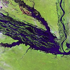
English: The Negro River flowing through the eastern edge of Brazil’s Jau National Park. The river is the big strip of blue running from left to right across the image, and the other blue ribbons are tributaries. Originating at the border of Venezuela and Brazil, the Negro River meets up with the Amazon in central Brazil to become its largest tributary. Half-submerged islands can be seen in the center of the river. Between November and April when the river is at its peak, many of these islands disappear. |
| Data | |
| Font |
http://earthobservatory.nasa.gov/Newsroom/NewImages/images.php3?img_id=10843
|
| Autor | NASA and USGS EROS Data Center Satellite Systems Branch |
Llicència
Aquesta imatge és de domini públic, ja que conté materials que originalment van venir del Servei Geològic dels Estats Units d'Amèrica, una agència del Departament de l'Interior dels Estats Units. Per a obtenir més informació, consulti la política oficial de drets de l'USGS.
|
Registre original de càrregues
La pàgina de descripció original era aquí. Els noms d'usuari a continuació es refereixen a en.wikipedia.
- 2003-11-23 05:55 Snoyes 750×750×8 (136760 bytes)
Historial del fitxer
Cliqueu una data/hora per veure el fitxer tal com era aleshores.
| Data/hora | Miniatura | Dimensions | Usuari/a | Comentari | |
|---|---|---|---|---|---|
| actual | 22:27, 4 abr 2008 | | 750 × 750 (134 Ko) | File Upload Bot (Magnus Manske) | {{BotMoveToCommons|en.wikipedia}} {{Information |Description={{en|'''Credit(s):''' [http://edc.usgs.gov/ USGS EROS Data Center] Satellite Systems Branch. '''Source:''' http://earthobservatory.nasa.gov/Newsroom/NewImages/images.php3?img_id=10843 ''?The |
Ús del fitxer
La pàgina següent utilitza aquest fitxer:
Ús global del fitxer
Utilització d'aquest fitxer en altres wikis:
- Utilització a ar.wikipedia.org
- Utilització a ast.wikipedia.org
- Utilització a ba.wikipedia.org
- Utilització a be.wikipedia.org
- Utilització a bg.wikipedia.org
- Utilització a de.wikipedia.org
- Utilització a de.wikivoyage.org
- Utilització a en.wikipedia.org
- Utilització a es.wikipedia.org
- Utilització a eu.wikipedia.org
- Utilització a fr.wikipedia.org
- Utilització a he.wikipedia.org
- Utilització a he.wikivoyage.org
- Utilització a hi.wikipedia.org
- Utilització a hr.wikipedia.org
- Utilització a id.wikipedia.org
- Utilització a it.wikivoyage.org
- Utilització a ja.wikipedia.org
- Utilització a ka.wikipedia.org
- Utilització a ko.wikipedia.org
- Utilització a lt.wikipedia.org
- Utilització a mai.wikipedia.org
- Utilització a ml.wikipedia.org
- Utilització a mt.wikipedia.org
- Utilització a ne.wikipedia.org
- Utilització a nl.wikipedia.org
- Utilització a pl.wikipedia.org
Vegeu més usos globals d'aquest fitxer.