Fitxer:Nasa AIRS CO2 July03.jpg
Mida d'aquesta previsualització: 800 × 595 píxels. Altres resolucions: 320 × 238 píxels | 640 × 476 píxels | 950 × 706 píxels.
Fitxer original (950 × 706 píxels, mida del fitxer: 505 Ko, tipus MIME: image/jpeg)
| Aquest fitxer i la informació mostrada a continuació provenen del dipòsit multimèdia lliure Wikimedia Commons. |
Resum
| Descripció |
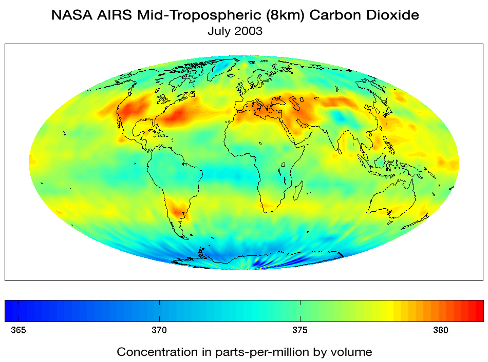
English: Although originally designed to measure atmospheric water vapor and temperature for weather forecasting, scientists working with the Atmospheric Infrared Sounder (AIRS) instrument on the NASA Aqua Spacecraft are now using AIRS to observe atmospheric carbon dioxide. Scientists from NASA, NOAA, ECMWF, UMBC, Princeton and CalTech using several different methods are measuring the concentration of carbon dioxide in the mid-troposphere (about 8 km above the surface). The global map of carbon dioxide above, produced by AIRS Team Leader Dr. Moustafa Chahine at JPL, shows that despite the high degree of mixing that occurs with carbon dioxide, the regional distribution can still be seen by the time the gases reach the mid troposphere. Climate modelers are currently using the AIRS data to understand the global distribution and transport of carbon dioxide and improve their models.
Português: Embora tenha sido originalmente criado para medir o vapor de água na atmosfera e temperatura para previsão do tempo, cientistas trabalharam com o Sondador Infravermelho Atmosférico (em inglês:Atmospheric Infrared Sounder - AIRS), para observar o Dióxido de Carbono atmosférico. Cientistas da NASA, NOAA, ECMWF, UMBC, Princeton e CalTech, utilizando diversos métodos estão medindo a concentração de Dióxido de Carbono na meia-Troposfera (cerca de 8km acima da superfície). O mapa global de dióxido de carbono em questão foi produzido pelo líder de equipe do AIRS no JPL (Jet Propulsion Lab) o Dr. Moustafa Chahine, mostra que apesar do alto grau de mistura que ocorre com o Dióxido de Carbono, a distribuição regional ainda pode ser notada quando os gases alcançam a meia-troposfera. Climatólogos atualmente usam os dados fornecidos pelo AIRS para entender a distribuição global e transporte do Dióxido de Carbono |
| Data | |
| Font | English: NASA Goddard Space Flight Center — Aqua Project Science: Global Map of Carbon Dioxide from Space |
| Autor |
English: "Image and text courtesy of the AIRS Science Team, JPL."
Português: "Imagem e texto são cortesia do Time de Ciência AIRS, JPL |
| Altres versions |
Llicència
| Aquest fitxer és en el domini públic perquè ha estat creat per la NASA. L'avís legal de la NASA diu que «el material de la NASA no està protegit per copyright si no es diu el contrari». (NASA copyright policy page o JPL Image Use Policy). | ||
 |
Atenció:
|
Historial del fitxer
Cliqueu una data/hora per veure el fitxer tal com era aleshores.
| Data/hora | Miniatura | Dimensions | Usuari/a | Comentari | |
|---|---|---|---|---|---|
| actual | 01:50, 14 oct 2007 | | 950 × 706 (505 Ko) | Delemon | {{Information |Description={{en|Although originally designed to measure atmospheric water vapor and temperature for weather forecasting, scientists working with the Atmospheric Infrared Sounder (AIRS) instrument on the NASA Aqua Spacecraft are now using A |
Ús del fitxer
La pàgina següent utilitza aquest fitxer:
Ús global del fitxer
Utilització d'aquest fitxer en altres wikis:
- Utilització a ar.wikibooks.org
- Utilització a de.wikiversity.org
- Utilització a en.wikipedia.org
- Utilització a pt.wikipedia.org
- Utilització a ru.wikipedia.org