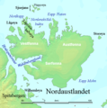
Fitxer:Nordaustlandet labelled.png
Nordaustlandet_labelled.png (524 × 528 píxels, mida del fitxer: 119 Ko, tipus MIME: image/png)
Historial del fitxer
Cliqueu una data/hora per veure el fitxer tal com era aleshores.
| Data/hora | Miniatura | Dimensions | Usuari/a | Comentari | |
|---|---|---|---|---|---|
| actual | 04:47, 29 jul 2006 |  | 524 × 528 (119 Ko) | TheGrappler | Remove cursor |
| 03:08, 29 jul 2006 |  | 524 × 528 (119 Ko) | TheGrappler | Correct spelling | |
| 02:40, 29 jul 2006 |  | 524 × 528 (119 Ko) | TheGrappler | == Summary == {{English}} Map detailing the marine features of Spitsbergen in the Svalbard archipelago. Settlements and mountains are indicated and labelled. See also Image:Spitsbergen mountains and marine features labelled.png. Locations were labell |
Ús del fitxer
La pàgina següent utilitza aquest fitxer:
Ús global del fitxer
Utilització d'aquest fitxer en altres wikis:
- Utilització a af.wikipedia.org
- Utilització a ast.wikipedia.org
- Utilització a az.wikipedia.org
- Utilització a ceb.wikipedia.org
- Utilització a cs.wikipedia.org
- Utilització a cy.wikipedia.org
- Utilització a da.wikipedia.org
- Utilització a de.wikipedia.org
- Utilització a el.wikipedia.org
- Utilització a en.wikipedia.org
- Nordaustlandet
- Wahlenbergfjorden
- Austfonna
- Wilhelm Island
- Hinlopen Strait
- Sjuøyane
- Vestfonna
- Augusta Bay (Nordaustlandet)
- Whalers Bay (Svalbard)
- Gustav Adolf Land
- Gustav V Land
- Bråsvellbreen
- Leighbreen
- Orvin Land
- Duvefjorden
- Rijpfjorden
- Etonbreen
- Prins Oscars Land
- Nordkappsundet
- Nordkapp (Nordaustlandet)
- Adlersparrefjorden
- Finn Malmgren Fjord
- Glenhalvøya
- Murchisonfjorden
- Lady Franklinfjorden
Vegeu més usos globals d'aquest fitxer.

